Unmanned aerial vehicle real-time map reconstruction method

A drone and map technology, applied in image enhancement, image analysis, image data processing, etc., can solve problems such as slow running speed and failure to achieve map reconstruction

Active Publication Date: 2016-06-15
NORTHWESTERN POLYTECHNICAL UNIV
View PDF5 Cites 42 Cited by
  • Summary
  • Abstract
  • Description
  • Claims
  • Application Information

AI Technical Summary

Problems solved by technology

However, the current 3D map reconstruction of visual SLAM still has the problem of slo

Method used


Image

  • Unmanned aerial vehicle real-time map reconstruction method
  • Unmanned aerial vehicle real-time map reconstruction method
  • Unmanned aerial vehicle real-time map reconstruction method

Examples


Embodiment Construction

[0051] Embodiments of the present invention are described in detail below, examples of which are shown in the drawings, wherein the same or similar reference numerals designate the same or similar elements or elements having the same or similar functions throughout. The embodiments described below by referring to the figures are exemplary and are intended to explain the present invention and should not be construed as limiting the present invention.

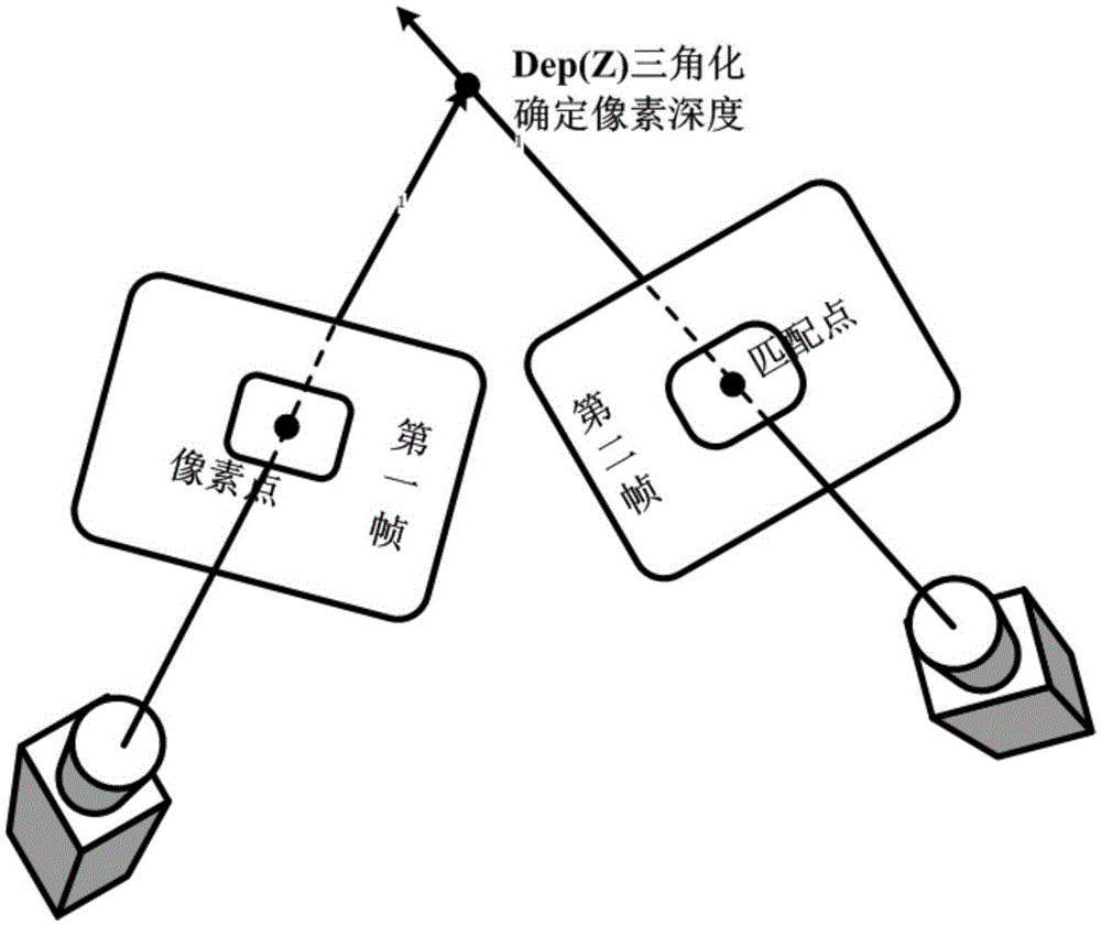
[0052] The UAV real-time map reconstruction method in the present embodiment comprises the following steps:

[0053] Step 1: Process the first frame image acquired by the camera as follows:

[0054] Step 1.1: Use the pre-acquired calibration data to perform de-distortion processing on the first frame of image to obtain the de-distorted first frame of image for subsequent processing.

[0055] Step 1.2: Initialize the depth of the first frame of image after dedistortion: according to the set gray gradient threshold, filter out the...


PUM


Abstract

The present invention provides an unmanned aerial vehicle real-time map reconstruction method. By applying an unmanned aerial vehicle, the three-dimensional maps of the surrounding environment of the unmanned aerial vehicle are obtained, and the own positioning of the unmanned aerial vehicle is realized. According to the method, the unmanned aerial vehicle flies in the unknown airspace, and on the condition that the own position of the unmanned aerial vehicle is not clear, the own positioning of the unmanned aerial vehicle is obtained and the three-dimensional maps are constructed by detecting and comparing the environmental information, and extracting and matching the feature information of the environment. The unmanned aerial vehicle real-time map reconstruction method also comprises the geographic information fusion and an image mosaic technology. The unmanned aerial vehicle real-time map reconstruction method of the present invention can be applied to the fields, such as the battlefield demands, for example the unmanned aerial vehicle autonomous flight and attack, the disaster emergency rescue, such as fire hazard, earthquake, flood, etc., the unmanned aerial vehicle security administration and monitoring, etc. Compared with the conventional method, and according to the present invention, a position drifting amount, an angle drifting amount or an absolute error is above the average, and more environmental information is obtained. Moreover, compared with a full-density method, an experimental precision of the method still can reach a usage standard, and the method can be operated on a CPU directly and is good in real-time performance.

Description

technical field [0001] The invention relates to the field of computer image processing and map surveying and mapping, in particular to a real-time map reconstruction method of an unmanned aerial vehicle, which uses an unmanned aerial vehicle to obtain a three-dimensional map of its surrounding environment in real time and realize its own positioning. Background technique [0002] Traditional surveying and mapping technology uses the feature points and boundaries of the ground to obtain graphics and position information reflecting the current status of the ground through measurement means (such as remote sensing, laser, ultrasonic, etc.). Traditional surveying and mapping technology has high requirements for sensors. Although its surveying and mapping accuracy is high, the high cost and the long time required from information collection to results have restricted the application of traditional surveying and mapping in some occasions (such as relatively high timeliness requirem...

Claims


Application Information

Patent Timeline
IPC IPC(8): G06T7/00
CPCG06T2207/10016G06T2207/30181
Inventor 布树辉张臻炜赵勇刘贞报
Owner NORTHWESTERN POLYTECHNICAL UNIV
Why Eureka
Try Eureka