Flood risk map plotting system and method based on B/S structure

A flood risk map and risk technology, applied in the fields of cartography and geographic engineering, can solve the problems of single output format, inability to meet the requirements of multiple formats and high-resolution mapping, and low resolution

Inactive Publication Date: 2016-07-13
北京艾森思科技有限公司 +1
View PDF3 Cites 2 Cited by
  • Summary
  • Abstract
  • Description
  • Claims
  • Application Information

AI Technical Summary

Problems solved by technology

[0004] At present, there are flood risk map drawing and drawing technologies based on the B / S structure, mainly using web page screenshot technology to generate flood risk map, and there are two ways to realize it: one is Flash screenshot, and the other is JavaScript screenshot. It uses web page screenshot technology, so it can only generate flood risk maps in picture format (such as png, jpg, gif, bmp), but cannot generate flood risk maps in EMF, EPS, AI, PDF, SVG, TIFF formats, so the The image format is single and the resolution is low, which cannot meet the requirements of multiple formats and high resolution.

Method used


Image

  • Flood risk map plotting system and method based on B/S structure
  • Flood risk map plotting system and method based on B/S structure
  • Flood risk map plotting system and method based on B/S structure

Examples


Embodiment 1

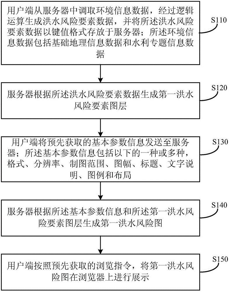
[0074] Such as figure 1 As shown, a B / S structure-based flood risk map drawing method provided by the embodiment of the present invention includes steps S110-S150:

[0075] Step S110, the client terminal 10 retrieves environmental information data from the server 20, generates flood risk element data through logical operations, and stores the flood risk element data in the server 20 in a key-value format; the environmental information data includes basic geographical Information data and special water conservancy information data.

[0076] Specifically, the process in which the client 10 retrieves the environment information data from the server 20 is a process of dynamically loading the environment information data. The above-mentioned client 10 is a web browser. In the web browser, the "layer selection" button on the risk drawing interface triggers a request for GIS dynamic service to superimpose basic geographic information data and water conservancy special information da...

Embodiment 2

[0115] Such as Image 6 As shown, the present invention also provides a flood risk map drawing and drawing system based on B / S structure corresponding to the method provided in Embodiment 1, and the system includes a client terminal 10 and a server 20 .

[0116] The client terminal 10 includes a calculation module 11 , a setting module 12 and a display module 13 , and the server 20 includes a layer generation module 21 and a first flood risk map generation module 22 .

[0117] The operation module 11 is used to retrieve the environmental information data from the server 20, generate flood risk element data through logical operation, and store the flood risk element data in the server 20 in a key-value format; the environmental information data includes basic geographical Information data and special water conservancy information data.

[0118] Specifically, the process in which the client 10 retrieves the environment information data from the server 20 is a process of dynamic...


PUM


Abstract

The invention provides a flood risk map plotting system and method based on a B/S structure.The method comprises the steps that a user side retrieves environment information data from a server, and flood risk factor data is generated through logical operation and saved in the server in a key value format; the server generates a first flood risk factor map layer according to the flood risk factor data; the user side sends basic parameter information acquired in advance to the server; the basic parameter information comprises one or more of the format, the resolution ratio, the drawing range, the mapsheet, the title, the explanatory note, the legend and the layout; the server generates a first flood risk map according to the basic parameter information and the first flood risk factor map layer; the user side displays the first flood risk map on a browser according to a browsing instruction acquired in advance.According to the flood risk map plotting system and method based on the B/S structure, the problems that a flood risk map drawn through the prior art is single in format and low in resolution ratio are solved.

Description

technical field [0001] The invention relates to the technical fields of cartography and geographic engineering, in particular to a B / S structure-based flood risk map drawing system and method. Background technique [0002] Flood risk depends on many factors such as disaster-causing factors, disaster-affected bodies, and disaster-prevention capabilities. Among the flood hazard factors, the main elements that affect the flood risk include flood source, flood submerged range, submerged water depth, submerged duration, flood velocity, flow direction, etc.; the main factors that reflect the impact of flood on the disaster-affected body include population, asset distribution and Density, etc.; disaster prevention capacity refers to the ability of the disaster-bearing body to resist floods, including the disaster-resistance capacity of the disaster-bearing body, emergency response capacity, post-disaster recovery capacity, flood control and waterlogging and other engineering facili...

Claims


Application Information

Patent Timeline
Patent Type & Authority Applications(China)
IPC IPC(8): G06F17/30G06T17/05
CPCG06F16/29G06T17/05Y02A10/40
Inventor 李红俊俞燕彦赖祥燃
Owner 北京艾森思科技有限公司
Why Eureka
Try Eureka