Road sign drawing and vehicle positioning method and system for automatic drive

A road marking and vehicle positioning technology, which is applied in the field of road marking mapping and vehicle positioning methods and systems, can solve problems such as positioning failure, centimeter-level positioning, and traffic scene interference, and achieve stable positioning, suitable for commercial promotion, Inexpensive effect

Active Publication Date: 2016-07-20
WUHAN ZHONGHAITING DATA TECH CO LTD
View PDF7 Cites 78 Cited by
  • Summary
  • Abstract
  • Description
  • Claims
  • Application Information

AI Technical Summary

Problems solved by technology

In urban traffic, centimeter-level positioning cannot be achieved by GNSS alone
If the combination of inertial navigation, inertial measurement unit and global satellite navigation system can achieve centimeter-level positioning, however, typical traffic scenes often have some interference, such as vegetation, building blockage or reflection, resulting in positioning failure

Method used


Image

  • Road sign drawing and vehicle positioning method and system for automatic drive
  • Road sign drawing and vehicle positioning method and system for automatic drive
  • Road sign drawing and vehicle positioning method and system for automatic drive

Examples


Embodiment Construction

[0030] In order to make the objectives, technical solutions and advantages of the present invention clearer, the present invention will be described in further detail below in conjunction with the accompanying drawings and embodiments. It should be understood that the specific embodiments described here are only used to explain the present invention and are not intended to limit the invention.

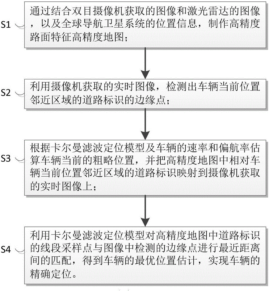
[0031] Such as figure 1 As shown, the embodiment of the present invention provides a road sign drawing and vehicle positioning method for automatic driving, and the road sign drawing and vehicle positioning method for automatic driving includes the following steps:

[0032] S1. By combining the image acquired by the binocular camera, the image of the laser radar, and the position information of the global navigation satellite system, a high-precision map of road surface characteristics is produced.

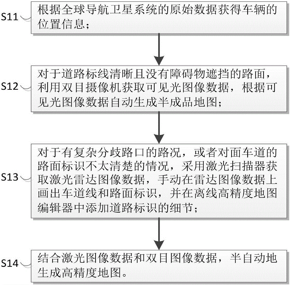
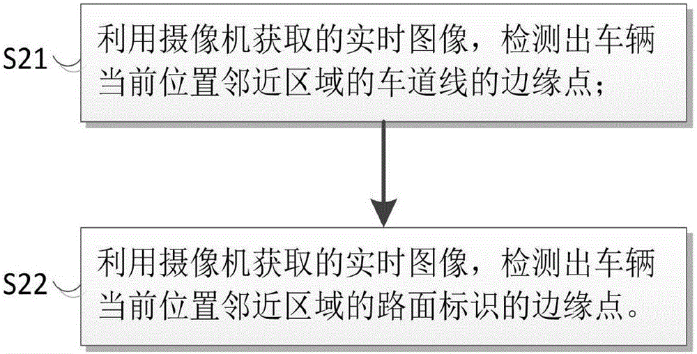
[0033] Specifically, such as figure 2 As shown, the step S1 includes the following ...


PUM


Abstract

The invention provides a road sign drawing and vehicle positioning method and system for automatic drive.Through cooperation use of a binocular camera and laser radar, a high-precision road surface characteristic map is generated semi-automatically, edge points of a road sign on an image acquired by the binocular camera are detected through the binocular camera, the edge points are matched with sampling points of a line segment on the high-precision road surface characteristic map, a Kalman filtering positioning model is used for optimization to find out optimal matching, and then vehicle positioning is completed.Through the road sign drawing and vehicle positioning method and system for automatic drive, positioning is stable, robustness is high, and the influence of shielding and reflection by vegetation barriers is avoided; meanwhile, compared with a radar sensor, the binocular camera is more suitable for commercial popularization due to price, low in price and suitable for civil use.

Description

technical field [0001] The invention relates to the technical field of automatic driving, in particular to a method and system for road sign drawing and vehicle positioning in automatic driving. Background technique [0002] With the development of computer science and robotics, self-driving vehicles have been widely used in military, civil and scientific research, etc., and it has concentrated the latest research results of multiple disciplines such as structure, electronics, cybernetics and artificial intelligence. ,with broadly application foreground. [0003] In the field of autonomous driving and assisted driving, high-precision and robust localization in real traffic scenes is particularly important. In urban traffic, centimeter-level positioning cannot be achieved only through global satellite navigation systems. If the combination of inertial navigation, inertial measurement unit and global satellite navigation system can achieve centimeter-level positioning, howev...

Claims


Application Information

Patent Timeline
Patent Type & Authority Applications(China)
IPC IPC(8): G01C21/34
Inventor 王军德刘伶俐
Owner WUHAN ZHONGHAITING DATA TECH CO LTD
Why Eureka
Try Eureka