Multi-satellite earth-observation task scheduling and planning method and device
A technology for earth observation and mission planning, applied in special data processing applications, instruments, electrical digital data processing, etc., can solve problems such as inability to optimize satellite system resource allocation
- Summary
- Abstract
- Description
- Claims
- Application Information
AI Technical Summary
Problems solved by technology
Method used
Image
Examples
Embodiment 1
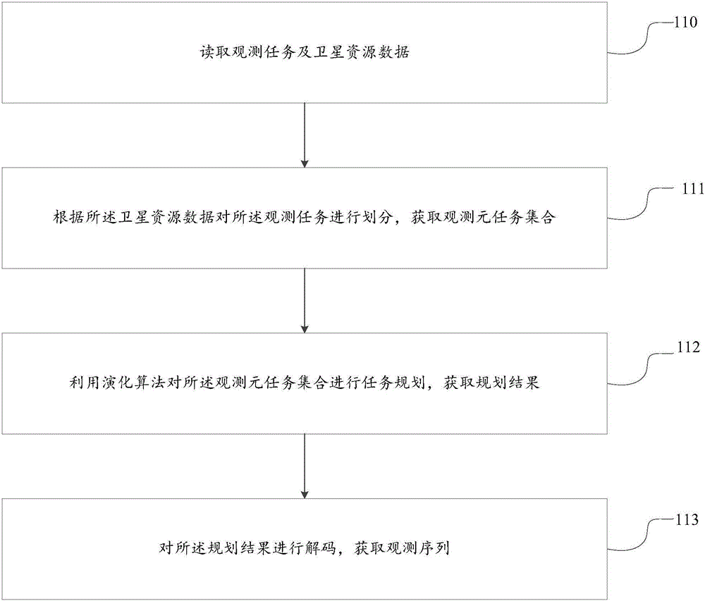
[0064] This embodiment provides a method for scheduling and planning multi-satellite earth observation missions, such as figure 1 As shown, the method includes the following steps:
[0065] Step 110, reading observation task and satellite resource data.
[0066] In this step, the observation task and satellite resource data are read from the satellite resource database, and the satellite resource data includes: satellite information, payload information, ground target information, and the like. The observation task is
[0067] Wherein, the satellite information includes: the satellite's orbital conditions, accuracy, and roll capability. The payload information refers to the equipment and load capacity carried by the satellite to obtain image data, such as: camera (hyperspectral, multispectral or panchromatic), synthetic aperture radar and various sensors (frequency band and wave band). The ground target refers to a ground area that needs to be observed, including: point tar...
Embodiment 2
[0175] Corresponding to Embodiment 1, this embodiment also provides a scheduling device for multi-satellite earth observation tasks, such as Figure 4 As shown, the device includes: a reading module 41, a division module 42, a planning module 43 and a decoding module 44; wherein,
[0176] The reading module 41 is used to read satellite resource data from the satellite resource database, and the satellite resource data includes: satellite information, payload information, ground target information, and the like. Wherein, the satellite information includes: the satellite's orbital conditions, accuracy, and roll capability. The payload information refers to the equipment and load capacity carried by the satellite to obtain image data, such as: camera (hyperspectral, multispectral or panchromatic), synthetic aperture radar and various sensors (frequency band and wave band). The ground target refers to a ground area that needs to be observed, including: point targets, area targets...
Embodiment 3
[0284] In practical applications, users can use evolutionary algorithms to plan satellite resource data through the man-machine interface of the multi-satellite earth observation mission system.
[0285] Specifically, such as Figure 5 Said, the system includes: application layer, algorithm layer, model layer and data layer; wherein, the data layer provides the physical data necessary for multi-satellite mission planning based on evolutionary calculation. Multi-satellite mission planning requires a large amount of data input and output. In order to improve computing efficiency, it is necessary to provide a data management method with certain independence. To this end, a database related to multi-satellite and multi-mission planning is constructed, which mainly includes observation task database, payload database, and satellite database, and also includes some auxiliary data.
[0286] The model layer implements the modeling process required for multi-satellite mission planning...
PUM
 Abstract
Description
Claims
Application Information
 - R&D
- Intellectual Property
- Life Sciences
- Materials
- Tech Scout
- Unparalleled Data Quality
- Higher Quality Content
- 60% Fewer Hallucinations
Browse by: Latest US Patents, China's latest patents, Technical Efficacy Thesaurus, Application Domain, Technology Topic, Popular Technical Reports.
© 2025 PatSnap. All rights reserved.Legal|Privacy policy|Modern Slavery Act Transparency Statement|Sitemap|About US| Contact US: help@patsnap.com


