Automatic matching method between point of interest and road network

An automatic registration and point-of-interest technology, applied in the field of geographic information, can solve the problems of automatic identification of control points with the same name, difficulty in obtaining reference road network data of points of interest, and problems such as points of interest not falling

Active Publication Date: 2016-08-03
CENT SOUTH UNIV
View PDF5 Cites 28 Cited by
  • Summary
  • Abstract
  • Description
  • Claims
  • Application Information

AI Technical Summary

Problems solved by technology

The traditional map matching method uses the location coordinates of the GPS track point and the geometric characteristics of the road network to match the track point to the corresponding road section, but the point of interest does not fall in the road area, and the map matching method cannot establish the matching relationship between the point of interest and the road network
The registration method based on road network matching uses the matching relationship of the road network to register the subordinate interest points of one road network to another road network. It i...

Method used


Image

  • Automatic matching method between point of interest and road network
  • Automatic matching method between point of interest and road network
  • Automatic matching method between point of interest and road network

Examples


Embodiment Construction

[0066] The present invention will be further described below in conjunction with the accompanying drawings and embodiments.

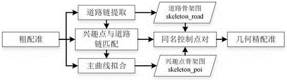
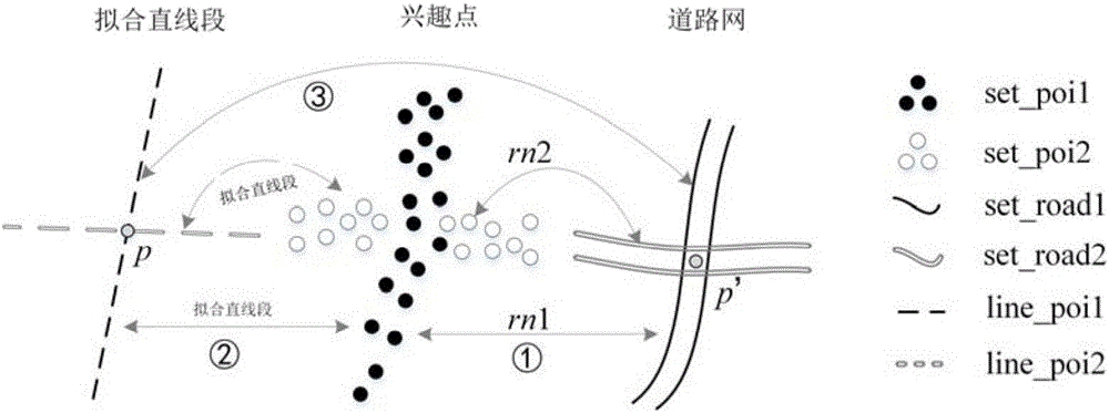
[0067] figure 1 It is the automatic registration process of the POI and the road network in the embodiment of the present invention. In the embodiment of the invention, firstly, by comparing the attribute information of the two POIs and the road network data, the POI is roughly registered to the target road network; and then the road network is extracted. The road chain mode in the road chain is constructed to construct the road skeleton map (skeleton_road); after that, the matching relationship between the interest points and the road chain is established through the partition-based spatial clustering method, and the interest cluster corresponding to the road chain is generated; on this basis, the interest points are extracted Based on the main curve characteristics of point clustering, construct a skeleton map of interest points (skeleton_poi); finall...


PUM


Abstract

The invention discloses an automatic matching method between a point of interest and a road network. The road attribute correlation in points of interest and the road network are made full use of to correct system deviation between points of interest from different sources and the road network; through building a road network skeleton map and a point of interest skeleton map, a geometric pattern correspondence relation between the point of interest and the road network is dug, a point-line homonymous control point recognition problem between the point of interest and the road network is converted into a skeleton map matching problem, and automatic position deviation correction between the points of interest from different sources and the road network data is carried out based on a skeleton map crossing point matching relation. The relative position precision of each space data can be greatly improved, manual intervention is reduced, and automatic and precise matching between the point of interest and the road network is realized.

Description

technical field [0001] The invention relates to the technical field of geographic information, in particular to an automatic registration method for an interest point and a road network. Background technique [0002] With the rapid development of sensors and Internet technologies, users can participate in the release and production of geospatial data through smart terminals and open map platforms. This kind of spatial data generated by users is called crowd source geospatial data (or volunteer geographic information). . Compared with professional surveying and mapping data, crowd-sourced geospatial data is quite different in terms of geometric expression, accuracy, scale, and data quality, which leads to problems such as repeated collection of spatial data from different sources and difficulties in information sharing. In the field of navigation and mobile location services, points of interest (POI) and road networks are the main data content. Points of interest and road ne...

Claims


Application Information

Patent Timeline
IPC IPC(8): G06T7/00G06K9/62
CPCG06T2207/10004G06V10/757
Inventor 张云菲邓敏
Owner CENT SOUTH UNIV
Why Eureka
Try Eureka