Method for measuring soil loss amount through military map

A soil loss and map technology, applied in the field of soil loss measurement and calculation, can solve the problems of large manpower and material resources investment, large measurement error, etc., and achieve the effect of small investment, simple and easy method, and accurate measurement

Inactive Publication Date: 2016-08-17
INST OF GEOCHEM CHINESE ACADEMY OF SCI
View PDF2 Cites 4 Cited by
  • Summary
  • Abstract
  • Description
  • Claims
  • Application Information

AI Technical Summary

Problems solved by technology

[0003] The technical problem to be solved by the present invention is to provide a method for measuring and calculating the amount of soil loss by using military maps

Method used


Image

  • Method for measuring soil loss amount through military map
  • Method for measuring soil loss amount through military map
  • Method for measuring soil loss amount through military map

Examples


Embodiment Construction

[0028] A method of measuring soil loss using military maps, which includes:

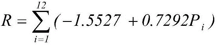
[0029] First, the determination of the R value of the rainfall erosion factor. Select an area where the slope is less than 15°, and the U.S. General Loss Equation allows a maximum slope of 18%, that is, 15°. By checking the local rainfall records, use the formula:

[0030] The result can be obtained. Among them, Pi is the monthly rainfall.

[0031] Second, the determination of soil erodibility factor K value. It can be calculated by formula: K=10 -3 (160.80-2.31X 1 +0.38X 2 +2.26X 3 +1.31X 4 +14.67X 5 )inferred.

[0032] Where: X 1 、X 2 、X 3 、X 4 、X 5 Respectively represent fine gravel (1-3㎜)%, fine sand (0.05-0.25㎜)%, coarse powder (0.01-0.05㎜)%, fine powder (0.005-0.01㎜)%, organic matter (10g / ㎏) .

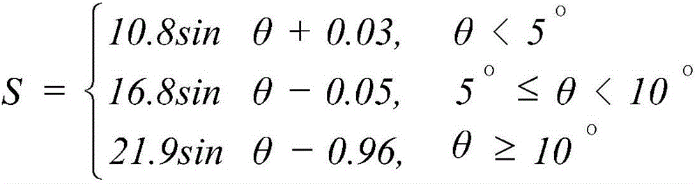
[0033] Third, the determination of the slope factor S. First use a two-foot gauge to measure the width between two or six contour lines on the map, then move the two-foot gauge to the...


PUM


Abstract

The invention discloses a method for measuring soil loss amount through a military map. The method comprises the first step of calculating a rainfall erosion factor R value, the second step of calculating a soil erodibility factor K value, the third step of calculating a slope factor S, the fourth step of calculating a slope length factor L, the fifth step of measuring a vegetation cover and management factor C, the sixth step of measuring a soil and water conservation measure factor P and the seventh step of calculating the soil loss amount. The method solves the technical problems that in the prior art, measuring errors for the soil loss amount are large, and manpower and material resource investment is large.

Description

Technical field: [0001] The invention belongs to the technical field of measuring and calculating soil loss, and in particular relates to a method for measuring and calculating soil loss by using a military map. Background technique [0002] There are many methods currently used to measure soil loss, such as hydrological station observation method, needle or piling method, runoff plot method, magnetic tracer method, etc. Hydrological station observation method: large investment, long duration, and the measured data is only It can reflect the loss and sediment production status of the entire watershed, but cannot obtain the amount of loss in different landform units or land use types in the watershed; needle insertion or piling method: it is easily affected by farming activities, and the annual loss is generally only a few millimeters, with large errors ; Runoff plot method: time-consuming, requires a lot of manpower and material resources input, can only get the loss of the ...

Claims


Application Information

Patent Timeline
IPC IPC(8): G01N33/24
CPCG01N33/24
Inventor 白晓永田义超陈秋芹许燕吴路华
Owner INST OF GEOCHEM CHINESE ACADEMY OF SCI
Why Eureka
Try Eureka