Interval confidence evaluation-based roadside node positioning method

A positioning method and node positioning technology, which are applied in the directions of location information-based services, wireless communication, electrical components, etc., can solve problems such as inaccurate vehicle positioning, improve robustness, meet accuracy requirements, and avoid the impact of positioning. Effect

Active Publication Date: 2016-08-24
GUANGDONG UNIV OF TECH
View PDF4 Cites 6 Cited by
  • Summary
  • Abstract
  • Description
  • Claims
  • Application Information

AI Technical Summary

Problems solved by technology

[0006] In order to solve the technical problem of inaccurate vehicle positioning in the mobile environment in the prior art, the present invention proposes a node positioning method along the road based on interval credibility evaluation, which is used in the self-organizing network of vehicles to assist nodes along the road in positioning. By dividing the communication area, Perform statistics and

Method used


Image

  • Interval confidence evaluation-based roadside node positioning method
  • Interval confidence evaluation-based roadside node positioning method
  • Interval confidence evaluation-based roadside node positioning method

Examples


Embodiment

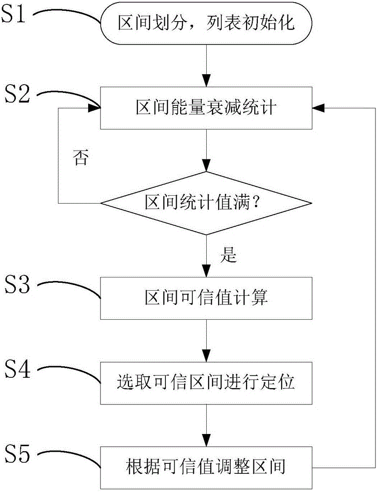
[0043] refer to figure 1 , the present invention is based on interval trustworthy evaluation node positioning method along the road, applied to the positioning of nodes along the road in the vehicle ad hoc network in a complex mobile environment, specifically includes the following steps:

[0044] Step 1: The nodes along the road initialize the parameters and variables, divide the adjacent road into N intervals according to their own communication radius R and road conditions, and establish an energy attenuation list P for each interval.

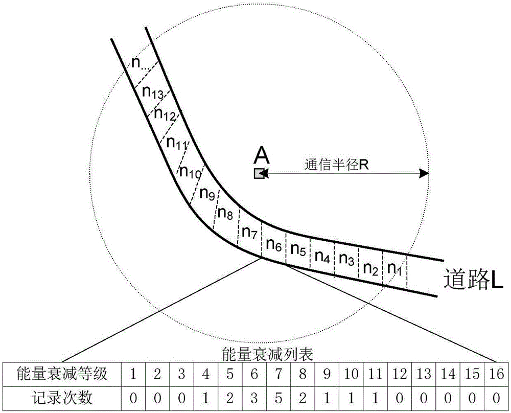
[0045] Such as figure 2 As shown, node A divides the area of ​​road L within the communication radius R into N intervals, n 1 , n 2 ,...,n N , in this embodiment, the road L is divided into equal distances to divide the intervals.

[0046] The energy attenuation list P described in step 1 includes the following contents: energy attenuation level and recording times. In this embodiment, the received signal energy attenuation value p is di...


PUM


Abstract

The invention provides an interval confidence evaluation-based roadside node positioning method. The method comprises steps: a roadside node initializes parameters and variables, and according to the self communication radius R and road conditions, adjacent roads are divided into N intervals, and an energy attenuation list P is built for each interval; according to received vehicle release information and signals, the roadside node carries out interval energy attenuation statistics; statistics is carried out on the energy attenuation list of each interval, and a confidence value of the interval is obtained; a confidence interval is selected for positioning; and readjustment is carried out according to the confidence value of the interval. Through dividing communication areas, statistics and analysis are carried out on position information and received signals of a large amount of vehicles, a vehicle coordinate interval with high confidence and interval signal propagation attenuation are selected for positioning calculation, position coordinates of the node is estimated, and an important role is played in application development of aspects such as positioning of a vehicle ad hoc network in a complicated environment and the safety.

Description

technical field [0001] The invention belongs to the technical field of vehicle ad hoc networks, and in particular relates to a method for locating nodes along a road in a vehicle ad hoc network in a complex mobile environment. Background technique [0002] As a specific application of mobile ad hoc network in intelligent transportation system, vehicle ad hoc network is a special form of ad hoc network with the characteristics of open structure and flexibility. Its huge application potential has been valued by academia and industry. The location-based service is an important application basis in the vehicular ad hoc network. [0003] Nodes along the road generally lack positioning devices due to cost issues. After this type of node is installed, it cannot obtain its own location information, and must analyze and calculate the current location based on the information released by other devices. The nodes of VANET are generally equipped with precise positioning systems, such ...

Claims


Application Information

Patent Timeline
IPC IPC(8): H04W4/02H04W64/00
Inventor 刘震宇李嘉俊刘洋
Owner GUANGDONG UNIV OF TECH
Why Eureka
Try Eureka