Method for obtaining map information, navigation method and device

A technology of map information and roadside equipment, which is applied in the field of communication, can solve problems such as untimely update, limited network status, large storage capacity of offline electronic maps, etc., and achieve the effect of saving storage space and traffic charges

Active Publication Date: 2019-06-07
FAFA AUTOMOBILE (CHINA) CO LTD
View PDF9 Cites 0 Cited by
  • Summary
  • Abstract
  • Description
  • Claims
  • Application Information

AI Technical Summary

Problems solved by technology

[0005] Embodiments of the present invention provide a method for obtaining map information, a navigation method, and equipment for solving the defects of large storage capacity of offline electronic maps, untimely updates, and real-time electronic maps that consume traffic and are limited by network conditions, and realize real-time update of local areas. Map, and a method of obtaining map information that is not limited by network status and traffic

Method used


Image

  • Method for obtaining map information, navigation method and device
  • Method for obtaining map information, navigation method and device
  • Method for obtaining map information, navigation method and device

Examples


Embodiment 1

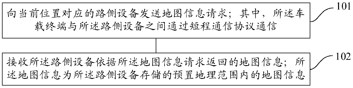
[0048] refer to figure 1 , which shows a flow chart of the steps of Embodiment 1 of a method for obtaining map information of the present invention, which is applied to a vehicle-mounted terminal, and may specifically include:

[0049] Step 101, sending a map information request to the roadside device corresponding to the current location; wherein, the vehicle-mounted terminal communicates with the roadside device through a short-range communication protocol;

[0050]The embodiment of the present invention can be applied to obtain map information in the process of driving navigation. In order to solve the problem that the existing technology needs to download the complete map information, which results in a large storage space or consumes traffic, the embodiment of the present invention can be stored in the roadside equipment. Map information within a preset geographic range, wherein the preset geographic range may include: the geographic area corresponding to the location of ...

Embodiment 2

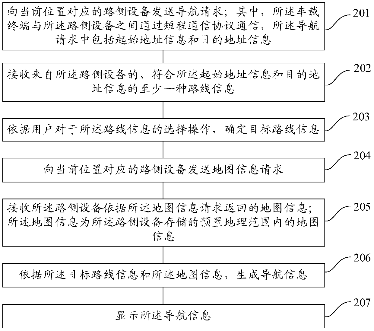
[0061] The embodiment of the present invention also provides a navigation method based on the map information obtained in the first embodiment above. Specifically, before the navigation starts, a navigation request is first sent to the roadside device, and the navigation request may include the starting address information and destination address information to obtain the route information corresponding to the navigation request, and then determine the target route information, so that the navigation information can be generated according to the map information requested from the roadside device and the target route information during driving, so as to realize driving navigation .

[0062] In an application example of the present invention, assuming that the vehicle intends to depart from the current location (location A) and arrive at location B, since it does not know how to drive, it can first determine the target route information, which usually includes: the location on th...

Embodiment 3

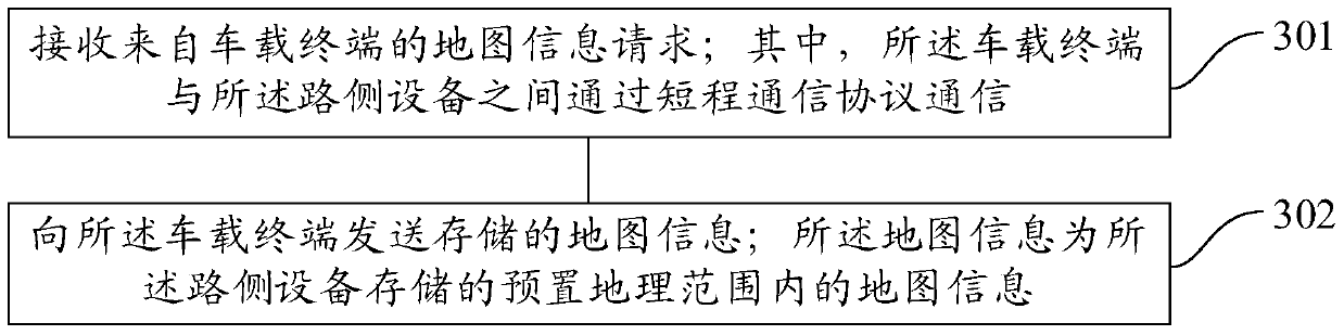
[0084] refer to image 3 , which shows a flow chart of steps in Embodiment 2 of a method for obtaining map information in the present invention, which is applied to roadside equipment, and may specifically include:

[0085] Step 301, receiving a request for map information from a vehicle-mounted terminal; wherein, the vehicle-mounted terminal communicates with the roadside device through a short-range communication protocol;

[0086] In the embodiment of the present invention, when the vehicle travels within the signal coverage of the roadside device, the roadside device may receive the map information request from the vehicle terminal.

[0087] Step 302, sending the stored map information to the vehicle terminal; the map information is the map information within the preset geographic range stored by the roadside device.

[0088] In the embodiment of the present invention, in order to reduce the storage burden of roadside equipment and the amount of data transmission between ...


PUM


Abstract

Embodiments of the present invention provide a method for obtaining map information, a navigation method, and equipment, wherein the method for obtaining map information specifically includes: sending a map information request to a roadside device corresponding to the current location; Communication between side devices through a short-range communication protocol; receiving map information returned by the roadside device according to the map information request; wherein the map information is map information within a preset geographical range stored by the roadside device. The embodiment of the present invention can save the storage space of the vehicle-mounted terminal, and can save the traffic charge of the vehicle-mounted terminal.

Description

technical field [0001] Embodiments of the present invention relate to the field of communication technologies, and in particular, to a method for acquiring map information, a navigation method, and a device. Background technique [0002] With the continuous development of electronic information technology, electronic maps have gradually replaced paper maps, bringing convenience to people's travel. For example, driving navigation technology can be equipped with an electronic navigation system through a car navigator, car machine or other equipment, and real-time navigation of the driving route based on the electronic map. [0003] Existing driving navigation technology can use offline electronic map or real-time electronic map for navigation. Among them, the technology of using offline electronic map for navigation needs to download a large amount of map information package in advance before driving navigation. The size of the map information package can usually reach hundre...

Claims


Application Information

Patent Timeline
Patent Type & Authority Patents(China)
IPC IPC(8): G01C21/32G01C21/34H04L29/08H04W4/80
CPCG01C21/34H04L67/06G01C21/3893H04W4/80
Inventor 李文锐徐勇邹禹陈昆盛林伟刘鹏李丹
Owner FAFA AUTOMOBILE (CHINA) CO LTD
Why Eureka
Try Eureka