Vector tile map making method

A technology of tile map and production method, which is applied in the direction of maps/plans/charts, geographic information databases, instruments, etc., can solve the problems of destroying the relative distribution characteristics of space, the map is not easy to read and use, and the map information expression effect is poor, etc. Achieve the effect of realizing value and meaning, maintaining correctness and coherence, and improving precision

Inactive Publication Date: 2016-10-12
WUHAN UNIV
View PDF6 Cites 18 Cited by
  • Summary
  • Abstract
  • Description
  • Claims
  • Application Information

AI Technical Summary

Problems solved by technology

This kind of vector data model, which takes the whole element as a unit, cannot be used for vector tile maps, because after the elements are divided by "tiles", the segmented geographical feature maps are symbolized independently, and the symbol graphics are in the "tiles". Visual incoherence such as graphic conflicts or breaks occurs at the stitching, and graphic conflicts will destroy the relative spatial distribution characteristics, making the expression effect of map information poor, resulting in cognitive obstacles for readers, making the map very inconvenient to read and use

Method used


Image

  • Vector tile map making method
  • Vector tile map making method
  • Vector tile map making method

Examples


Embodiment Construction

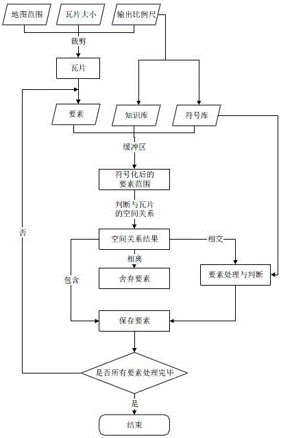
[0033] In order to facilitate those of ordinary skill in the art to understand and implement the present invention, the present invention will be described in further detail below in conjunction with the accompanying drawings and embodiments. It should be understood that the implementation examples described here are only used to illustrate and explain the present invention, and are not intended to limit this invention.

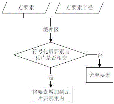
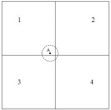
[0034] The present invention proposes a set of processing and clipping algorithms for different types of geographic key elements according to different types of geographical elements, combined with the symbols of the elements themselves, so as to realize the correctness and coherence of the overall symbol expression of the elements in the vector tile.

[0035] please see figure 1 , a method for making a vector tile map provided by the invention, comprising the following steps:

[0036] Step 1. According to the range of the vector map to be tiled, the width a...


PUM


Abstract

The invention discloses a vector tile map making method. The method comprises the steps of firstly determining the total number of tiles, a knowledge base and a symbol library corresponding to the tile map as well as a spatial resolution of each output tile according to a range of a vector map to be subjected to tile processing, the width and height of each output tile and a map scale of each output tile; secondly calculating a geographical range of one tile according to top left corner coordinates of the vector map, the geographical width and height of the tile and row and column numbers of the tile, and performing cutting and processing on vector map elements by taking the tile range as a cutting frame; and finally performing element processing and processed element storage on the vector map according to the geographical range, as the cutting frame, of the tile. According to the method, geographical elements in the generated vector tile map can be interactively accessed and the correctness and continuity of overall symbol expression of the geographical elements of the tiles can be kept.

Description

technical field [0001] The invention belongs to the technical field of map drawing, in particular to a method for making a vector tile map. Background technique [0002] With the rapid development of wireless communication, computer technology and geospatial information technology, network electronic map has become an indispensable part of people's daily life and work activities. From simple location queries to various navigation and positioning services and the latest street view maps and indoor maps, electronic maps are affecting and improving people's lives all the time. [0003] Due to the relatively large amount of map data, taking into account network transmission efficiency and user experience, electronic maps such as Google Maps, Yahoo Maps, and Virtual Earth took the lead in using map "tile technology". Afterwards, in the form of pictures, it is divided into tile sets that are spatially related and adjacent to cover the entire mapping area. According to the scope o...

Claims


Application Information

Patent Timeline
Patent Type & Authority Applications(China)
IPC IPC(8): G06F17/30G09B29/00
CPCG06F16/29G09B29/005
Inventor 李霖胡玮毛凯朱海红
Owner WUHAN UNIV
Why Eureka
Try Eureka