Multi-source remote sensing satellite data parallel processing system and method based on algorithm classification

A technology for parallel processing and remote sensing satellites, which is applied in the field of satellite data processing and application, and can solve the needs of satellite data comprehensive processing and application scalability, low resource utilization, inability to match satellite data types, satellite data processing algorithms, data archiving and storage and other issues to achieve the effect of reducing data throughput bottlenecks, improving production efficiency, and reducing data migration

Active Publication Date: 2016-10-12
CHINA CENT FOR RESOURCES SATELLITE DATA & APPL
View PDF6 Cites 25 Cited by
  • Summary
  • Abstract
  • Description
  • Claims
  • Application Information

AI Technical Summary

Problems solved by technology

[0004] The technical problem solved by the present invention is: to overcome the deficiencies of the existing technology, and provide a multi-source remote sensing satellite data parallel processing system and method based on algorithm classification, so as to solve the problem that the remote sensing satellite data processing system cannot match more and more complicated The types of satellite d

Method used


Image

  • Multi-source remote sensing satellite data parallel processing system and method based on algorithm classification
  • Multi-source remote sensing satellite data parallel processing system and method based on algorithm classification
  • Multi-source remote sensing satellite data parallel processing system and method based on algorithm classification

Examples


Embodiment 1

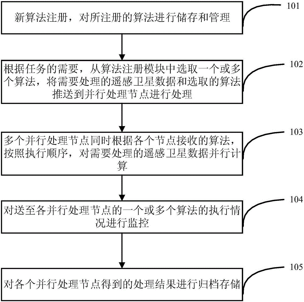
[0034] In the existing technology, the remote sensing satellite data processing system cannot match the increasingly complex satellite data types, satellite data processing algorithms, and massive data archiving and storage needs, which restricts the poor scalability and low resource utilization of satellite data comprehensive processing and application. Disadvantages, the embodiment of the present application realizes the matching of massive satellite data and complex satellite data processing algorithms, and provides the capability of high-performance and fast parallel computing of satellite data.

[0035] combined with figure 1 The schematic diagram of the system framework further illustrates this embodiment, and the method includes the following steps:

[0036] The algorithm registration module 101 supports the registration of new algorithms, and stores and manages the registered algorithms. The main execution process of the new algorithm should not include human-computer...

Embodiment 2

[0047] On the basis that the algorithm registration module 101 of Embodiment 1 supports new algorithm registration, stores and manages the registered algorithm, and uses XML language to write the parameter list required by the algorithm according to the set interface specification, this embodiment provides A detailed XML language parameter definition, as shown in Table 1, the algorithm parameter definition is as follows in Table 1:

[0048] Table 1 Parameter definition content

[0049]

[0050]

[0051] 1. The [ProductName] tag mentioned in the parameter definition is the algorithm name;

[0052] 2. The [ManualParams] tag contains all the parameter values ​​required by each sub-algorithm, including the file type parameter [FileArg] and the numerical type parameter [ValueArg];

[0053] 3. The [ModelArgs] tag contains all the specified parameters of the sub-algorithm. If the algorithm contains multiple sub-operators, the parameter definition also includes multiple corresp...

Embodiment 3

[0058] On the basis of selecting one or more required algorithms from the algorithm registration module according to the requirements of the tasks described in the first embodiment, the algorithm push module 102 , this embodiment provides a specific selection strategy for different remote sensing algorithms. For the complex satellite data processing algorithm, according to the preset strategy, it is decomposed into one or more series of sub-algorithms with a certain trigger mechanism, and each sub-algorithm can be described as the basic form of parallel computing - Mapping (Map) and Jane (Reduce). For example, algorithms such as offshore oil spill simulation and storm surge monitoring should be decomposed into a series of sub-algorithm chains with a certain trigger mechanism;

[0059] The EOS soil water content inversion algorithm can be regarded as including only one sub-algorithm.

[0060] Among them, for different algorithm types, the following decomposition setting strate...


PUM


Abstract

Provided is a multi-source remote sensing satellite data parallel processing system and method based on algorithm classification. The system and method support new algorithm register, store and manage the registered algorithm, select one or more algorithms from a algorithm register module, push remote sensing satellite data required to be processed and the selected algorithms to a parallel processing node to be processed; the parallel processing nodes simultaneously parallel compute the remote sensing satellite data required to be processed according to the algorithms received by nodes and an executing order; monitors the execution of the algorithms pushed to the parallel processing nodes; and files and stores processed results acquired by the parallel processing nodes. The system and the method support various remote sensing algorithm and multi-source remote sensing data, may simultaneously respond to and execute a multi-source remote sensing data processing request in a distributed cluster, solves multi-source remote sensing satellite data multi-algorithm comprehensive processing, parallel computing, and distributed storage, and achieve a multi-source remote sensing satellite data parallel processing effect.

Description

technical field [0001] The invention relates to a multi-source remote sensing satellite data parallel processing system and method based on algorithm classification, which belongs to the field of satellite data processing and application. Background technique [0002] Satellite data processing refers to processing the original data downloaded from satellites into corresponding images, and extracting various information from satellite data. With the global, high dynamic, continuous, all-weather, all-time, Diversified data acquisition features are widely used to provide data support for professional fields such as agriculture, forestry, water conservancy, surveying and mapping, transportation, meteorology, and oceanography. Its purpose is to execute specific data processing algorithms as stably and quickly as possible under limited hardware conditions to produce high-quality satellite data products. [0003] After years of development, my country's satellite information acqui...

Claims


Application Information

Patent Timeline
IPC IPC(8): G06K9/00G06K9/62
CPCG06V20/13G06F18/24
Inventor 曹宇王峰祝令亚孙业超
Owner CHINA CENT FOR RESOURCES SATELLITE DATA & APPL
Why Eureka
Try Eureka