Method for integrally managing geographic information and cartographic data

A technology of cartographic data and geographic information, applied in geographic information databases, structured data retrieval, maps/plans/charts, etc., can solve the problems of inability to meet the requirements of cartography, mutual conversion difficulties, data redundancy, etc., and improve production and management level, improving drawing efficiency, and the effect of large degrees of freedom

Active Publication Date: 2016-10-26
西安测绘研究所
View PDF8 Cites 12 Cited by
  • Summary
  • Abstract
  • Description
  • Claims
  • Application Information

AI Technical Summary

Problems solved by technology

[0002] Geographic information and cartographic data are generally regarded as two separate sets of data. The former focuses on the management, query and analysis of geographic information, which cannot meet the requirements of cartography. The latter focuses on the accuracy and beauty of cartographic expression, and cannot take into account the needs of data analysis.
The main limitation of this mutual separation and non-correlation is: the two sets of data are stored and updated in a completely separate manner, and there are great difficulties in mutual conversion, and it is difficult to ensure the consistency of the two data, resulting in a large amount of data redundancy , which reduces the efficiency of map making and greatly increases the cost of map making

Method used


Image

  • Method for integrally managing geographic information and cartographic data
  • Method for integrally managing geographic information and cartographic data
  • Method for integrally managing geographic information and cartographic data

Examples


Embodiment

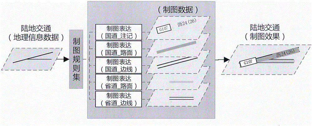
[0052] Take the mapping data corresponding to the generation of road data as an example, as shown in the attached image 3 As shown, the left side of the figure shows two pieces of road data corresponding to geographic information. Driven by the cartographic rule set, it has undergone conventional symbolic expression (such as national road number boxes, road pavement symbols and road edge symbols), and cartographic annotation processing (such as " Lek 24 (26)") and capping relationship processing (for example, after marking the capped road surface and road sidelines, the road surface and sidelines need to be hidden) to generate the final drawing data, the effect is shown on the right of the attached figure. At the same time, the geographic information corresponding to the two roads is associated with the mapping data through the same FUID. Once the geographic information changes, the corresponding mapping data will be updated in tandem.


PUM


Abstract

The invention relates to cartography, in particular to a method for integrally managing geographic information and cartographic data used in a digital map and a GIS (geographical information system, the same hereinafter). The problems that the geographic information and the cartographic data are mutually independent and not associated with each other, conversion is difficult and the consistency cannot be easily ensured can be effectively solved. According to the technical scheme, the cartographic data conforming to the map publishing requirements are obtained through mapping treatment of regular symbolization, special mapping effect treatment, lettering configuration, symbolic conflict treatment and the like of the geographic information; and the element-level association between the geographic information and the cartographic data is built in a database through a unique identifier of the element. By the method, integral management can be effectively carried out on the geographic information and the cartographic data; and the geographic information production and management levels are improved.

Description

1. Technical field [0001] The invention relates to map drawing, especially a method for integrated management of geographical information and map drawing data used in digital maps and GIS (Geographic Information System, the same below). 2. Background technology [0002] Geographic information and cartographic data are generally regarded as two separate sets of data. The former focuses on the management, query and analysis of geographic information, which cannot meet the requirements of cartography. The latter focuses on the accuracy and beauty of cartographic expression, and cannot take into account the needs of data analysis. . The main limitation of this mutual separation and non-correlation is: the two sets of data are stored and updated in a completely separate manner, and there are great difficulties in mutual conversion, and it is difficult to ensure the consistency of the two data, resulting in a large amount of data redundancy , which reduces the efficiency of map m...

Claims


Application Information

Patent Timeline
IPC IPC(8): G06F17/30G09B29/00
CPCG06F16/29G09B29/003G09B29/007
Inventor 安晓亚刘平芝金澄王峰熊顺徐道柱焦洋洋
Owner 西安测绘研究所
Why Eureka
Try Eureka