Geographic information data acquisition and display system

A geographic information data and display system technology, applied in the field of geographic information data collection and display systems, can solve problems such as time-consuming and labor-intensive, single function, and data transmission interruption, and achieve the effects of reducing costs, ensuring real-time transmission, and reducing workload

Inactive Publication Date: 2016-11-02
PINGDINGSHAN UNIVERSITY
View PDF4 Cites 25 Cited by
  • Summary
  • Abstract
  • Description
  • Claims
  • Application Information

AI Technical Summary

Problems solved by technology

[0002] Most of the existing geographic data information collection systems use cameras and geographic information collection devices to collect geographic data, and then manually perform fusion processing in the later stage, which is time-consuming and labor-intensive. At the same time, the following defects are common:
[0003] (1) Before collecting geographic information, it is necessary to lay communication lines to meet the real-time transmission of the collected data. Once the signal is not good, it is easy to cause data transmission interruption, which is very inconvenient to use, and the maintenance cost is also high;
[0004] (2) The data collected by the camera is the data of a single surface, so that the obtained video data cannot be used for panoramic display of the geographical environment;
[0005] (3) The display of the collected data is mostly displayed in a flat three-dimensional module, with low fidelity;
[0006] (4) The established 3D module cannot perform various simulation analysis and has a single function

Method used


Image

  • Geographic information data acquisition and display system

Examples


Embodiment Construction

[0038] In order to make the objects and advantages of the present invention clearer, the present invention will be further described in detail below in conjunction with the examples. It should be understood that the specific embodiments described here are only used to explain the present invention, not to limit the present invention.

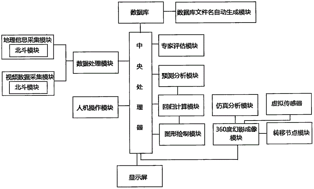
[0039] Such as figure 1 As shown, the embodiment of the present invention provides a geographic information data collection and display system, including a geographic information collection module, with a built-in Beidou module for real-time acquisition of geospatial information data, and the collected data is sent to the data center through the Beidou module processing module;

[0040] The man-machine operation module is used to input relevant geographic information data and send the input data to the data processing module; it is used to input data calling commands;

[0041] The video data acquisition module collects 360-degree panoramic vid...


PUM


Abstract

The invention discloses a geographic information data acquisition and display system, including a geographic information acquisition module, a man-machine operation module, a video data acquisition module, a data processing module, an expert evaluation module, a graphics rendering module, a regression calculating module, a prediction analyzing module, a central processor, a database file name automatic generation module, a 360-degree phantom imaging module, a simulation analyzing module, a virtual sensor, a transfer node module and a display. The simulation analyzing module repeatedly executes a simulation analyzing algorithm or a simulation analyzing method and transmits the feedback results to the virtual sensor. The virtual sensor receives the feedback results and automatically displays the data. According to the invention, a Beidou module is adopted to achieve data transmission through short messages, which greatly reduces the cost, ensures the real-time transmission of data, reduces the workload of the workers while achieving the 3D simulation of geographic information and comprehensive simulation and analysis of 3D three-dimensional geographic module so as to provides the reliable basis for corresponding measures.

Description

technical field [0001] The invention relates to the field of geographic data collection, in particular to a geographic information data collection and display system. Background technique [0002] Most of the existing geographic data information collection systems use cameras and geographic information collection devices to collect geographic data, and then manually perform fusion processing in the later stage, which is time-consuming and labor-intensive. At the same time, the following defects are common: [0003] (1) Before collecting geographic information, it is necessary to lay communication lines to meet the real-time transmission of the collected data. Once the signal is not good, it is easy to cause data transmission interruption, which is very inconvenient to use, and the maintenance cost is also high; [0004] (2) The data collected by the camera is the data of a single surface, so that the obtained video data cannot be used for panoramic display of the geographica...

Claims


Application Information

Patent Timeline
Patent Type & Authority Applications(China)
IPC IPC(8): G06F17/30G06T17/05H04W4/12
CPCG06F16/29G06T17/05H04W4/12
Inventor 陈延辉宫蕾岳汉秋甘泉史彬峰吴楠楠孙琼琼
Owner PINGDINGSHAN UNIVERSITY
Why Eureka
Try Eureka