
A method for combining rough matching and fine matching of underwater terrain images based on fitness analysis

An underwater terrain and adaptability technology, which is applied in image analysis, image enhancement, image data processing, etc., can solve the problems of poor matching effect and small feature change range, so as to improve the accuracy of matching and positioning, reduce time consumption, Effect of good rotation invariance

Active Publication Date: 2018-10-26
HARBIN ENG UNIV
View PDF4 Cites 0 Cited by
  • Summary
  • Abstract
  • Description
  • Claims
  • Application Information

AI Technical Summary

Problems solved by technology

For each type of underwater terrain, the auxiliary navigation system has different working capabilities. For example, the underwater terrain auxiliary navigation system relies on the multi-beam bathymetry system, so in areas where the terrain elevation changes greatly, its characteristics change greatly. , can perform well in the matching process, and the area with small terrain elevation changes has a small feature change range, and the matching effect is relatively poor

Method used


Image

  • A method for combining rough matching and fine matching of underwater terrain images based on fitness analysis
  • A method for combining rough matching and fine matching of underwater terrain images based on fitness analysis
  • A method for combining rough matching and fine matching of underwater terrain images based on fitness analysis

Examples


Embodiment Construction

[0040] The present invention will be further described in detail below in conjunction with the accompanying drawings and specific embodiments.

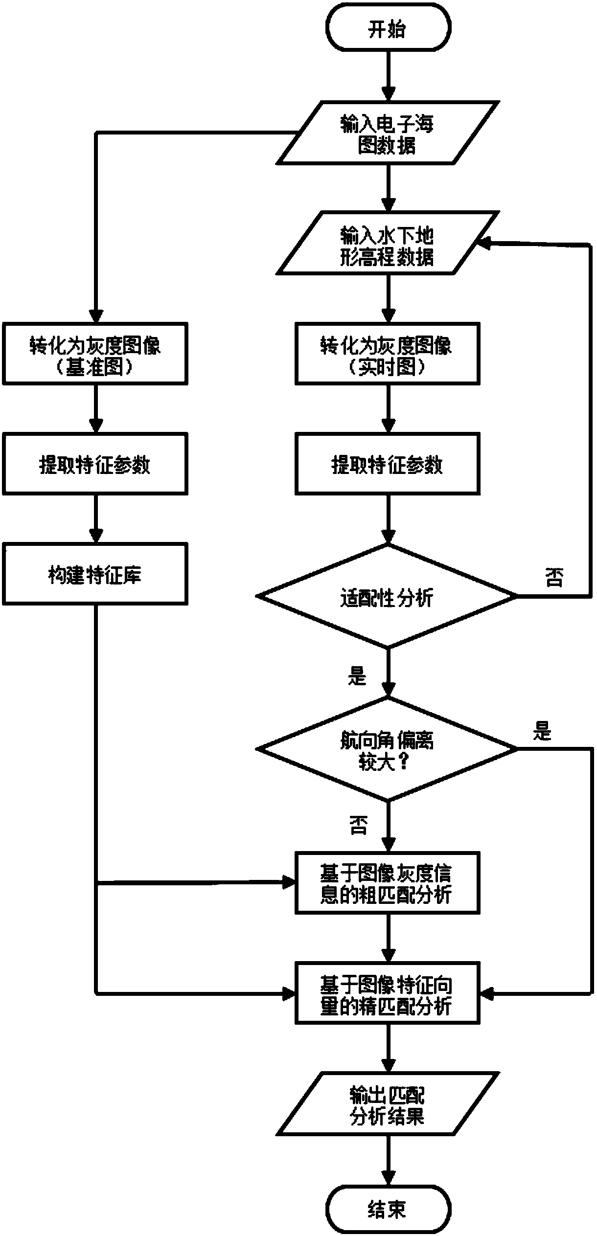
[0041] The invention is used for real-time positioning of underwater submersibles. Obtain real-time images of the underwater terrain elevation data detected by the sonar system. Under the circular matching template, first analyze the adaptability in the template area, and if it is suitable for matching, then select different matching methods according to the deviation degree of the heading angle to match the area to be measured. If the deviation of the heading angle is large, the fine matching method is adopted directly; if the deviation of the heading angle is small, the faster layered matching method from coarse to fine is adopted. Among them, the absolute difference algorithm of gray level is used for rough matching of underwater terrain images; the fine matching step is to select the maximum correlation coefficient of gray level ...


PUM


Abstract

The invention provides an underwater terrain image coarse matching and fine matching combined method based on suitability analysis. Real-time images of the underwater terrain elevation data detected by a sonar system are acquired. Suitability of a template area is analyzed firstly, and different matching modes are selected through the deviation degree of the course angle for performing matching of an area to be measured if the template area is suitable for matching If deviation of the course angle is large, a fine matching mode is directly used; and if deviation of the course angle is small, a coarse-to-fine layered matching mode is used. Coarse matching is performed on the underwater terrain images by using a gray absolute different algorithm; and the fine matching steps are that the maximum correlation coefficient of a gray co-occurrence matrix, the mean of a gray-gradient co-occurrence matrix and seven invariant moments, nine characteristic parameters in total, are selected to form characteristic vectors, and fine matching is performed on the images by using the characteristic vectors. The underwater terrain suitability can be greatly judged under the condition of using the same position matching algorithm under the same external interference so that the correct rate of judgment can be enhanced.

Description

technical field [0001] The invention relates to a digital image processing technology, in particular to a method for combining rough matching and fine matching of underwater terrain images based on adaptability analysis. Background technique [0002] Adaptability of underwater terrain is an analysis to judge whether a piece of underwater terrain is suitable for matching and positioning in the terrain database. The complexity of underwater terrain determines the degree of variation of its characteristic parameters. Therefore, the uniqueness of each piece of underwater terrain is a key factor determining its accuracy in the process of matching and positioning. For each underwater terrain, the auxiliary navigation system has different working capabilities. For example, the underwater terrain auxiliary navigation system relies on the multi-beam bathymetry system, so in areas where the terrain elevation changes greatly, its characteristics change greatly. , can perform well in t...

Claims


Application Information

Patent Timeline
Patent Type & Authority Patents(China)
IPC IPC(8): G06T7/33
CPCG06T2207/10004
Inventor 卞红雨陈奕名王鹏吴远峰金月
Owner HARBIN ENG UNIV
Learn More