Base station position locating method based on road test data

A positioning method and technology of drive test data, applied in electrical components, wireless communication, network planning, etc., can solve problems such as insufficient classification accuracy, insufficient positioning accuracy, and clustering and segmentation without considering signal correlation.

Inactive Publication Date: 2016-11-23
HANGZHOU DIANZI UNIV
View PDF3 Cites 15 Cited by
  • Summary
  • Abstract
  • Description
  • Claims
  • Application Information

AI Technical Summary

Problems solved by technology

In practical applications, the clustering block does not consider the correlation of signals...

Method used


Image

  • Base station position locating method based on road test data
  • Base station position locating method based on road test data
  • Base station position locating method based on road test data

Examples


Embodiment Construction

[0013] The present invention will be further described below in conjunction with accompanying drawing.

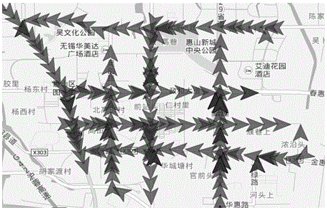
[0014] Such as figure 1 As shown in Fig. 1, professional drive test equipment is used to collect base station drive test data in the positioning target area, and the collection track is based on the urban road conditions. Each red mark in the figure represents a data sampling point, and each sampling point contains data of various standards of China Mobile, China Unicom, and China Telecom, as well as WIFI data information. Taking Telecom 4G as an example, the parameter information is shown in the table below.

[0015]

[0016] Specific steps are as follows:

[0017] Step 1: Filter out all collection points belonging to a certain (LAC, CI) area from the collected data according to the (LAC, CI) value.

[0018] Step 2: Find all collection point pairs with the same RSSI value from the above screened point set, and set the vertical bisector equation of the i-th pair of co...


PUM


Abstract

The invention discloses a base station position locating method based on road test data. The method includes: collecting base station signal road test original data, and performing polar coordinate conversion on the original data; whitening converted data; performing k-means clustering on whitened data, and determining a data central point; performing polar coordinate reversion on the determined central point to acquire coordinate information, namely physical position of a current base station. By studying road test big data and fully considering discreteness and relevance of data points, a method for performing polar coordinate conversion and whitening on the original data is provided, and a k-means clustering algorithm is utilized to realize physical position locating of the base station finally. Acquisition of physical position coordinates of the base station is of important reference significance in intensity distribution and coverage distribution of signals of the base station.

Description

technical field [0001] The invention belongs to the field of big data applications, and relates to a method for locating base station positions based on drive test data. Background technique [0002] The new generation of information and communication technology represented by the Internet of Things, big data and cloud computing is developing rapidly. The Internet of Things technology is accelerating its penetration into various fields through continuous integration with other new technologies. Accurate node positioning is the key to the location service application of the Internet of Things. The essential. At the same time, "big data" has become a hot word in people's production and life today. Ubiquitous social and commercial activities continuously generate various data. For example, the signaling data of base stations collected by specific departments in some cities is one of them. . The research value of positioning technology based on drive test big data is huge, esp...

Claims


Application Information

Patent Timeline
IPC IPC(8): H04W16/00H04W16/18H04W24/02H04W64/00
CPCH04W16/00H04W16/18H04W24/02H04W64/00
Inventor 元广杰苑鹏李小东江照意郭志潍
Owner HANGZHOU DIANZI UNIV
Why Eureka
Try Eureka