Unmanned aerial vehicle emergency communication path planning method and system

A path planning and emergency communication technology, applied in the field of drones, can solve the problem that the search path cannot be guaranteed, and achieve the effects of good real-time and rapidity, the shortest flight time, and the optimal path

Inactive Publication Date: 2016-12-07
GUILIN UNIV OF ELECTRONIC TECH
View PDF4 Cites 25 Cited by
  • Summary
  • Abstract
  • Description
  • Claims
  • Application Information

AI Technical Summary

Problems solved by technology

The ant colony algorithm is a global planning method that can consider multiple goals at the same time, but when the environment changes sudd

Method used


Image

  • Unmanned aerial vehicle emergency communication path planning method and system
  • Unmanned aerial vehicle emergency communication path planning method and system
  • Unmanned aerial vehicle emergency communication path planning method and system

Examples


Embodiment Construction

[0064] The principles and features of the present invention are described below in conjunction with the accompanying drawings, and the examples given are only used to explain the present invention, and are not intended to limit the scope of the present invention.

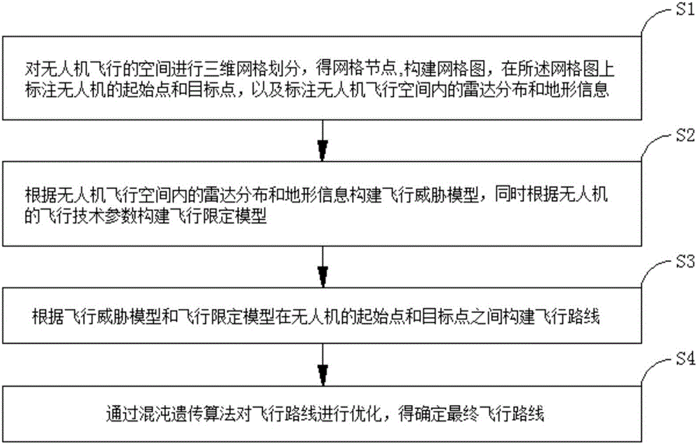
[0065] Such as figure 1 As shown, a UAV emergency communication path planning method includes the following steps:

[0066] Step 1. Carry out three-dimensional grid division on the flying space of the UAV, obtain grid nodes, construct a grid diagram, mark the starting point and target point of the UAV on the grid diagram, and mark the flight of the UAV Radar distribution and terrain information in space;

[0067] Step 2. Construct a flight threat model according to the radar distribution and terrain information in the flight space of the UAV, and construct a flight limitation model according to the flight technical parameters of the UAV;

[0068] Step 3. Construct a flight route between the starting point and the ...


PUM


Abstract

The invention relates to an unmanned aerial vehicle emergency communication path planning method and system. The method includes following steps: step 1, performing three-dimensional grid division on space in which an unmanned aerial vehicle flies to acquire grid nodes, building a grid chart, marking a starting point and a target point of the unmanned aerial vehicle, and marking radar distribution and topographic information; step 2, according to the radar distribution and the topographic information in the space in which the unmanned aerial vehicle flies, building a flying threat model and a flying limitation model at the same time; step 3, building flying paths according to the flying threat model and the flying limitation model; step 4, optimizing the flying paths through a chaos genetic algorithm to determine a final flying path. Compared with the prior art, the unmanned aerial vehicle emergency communication path planning method and system have the advantages that interference of low-altitude obstacles and radar can be avoided safely, shortest flying time and optimal paths to reach specified end points can be realized, and instantaneity and quickness are high.

Description

technical field [0001] The invention relates to the technical field of unmanned aerial vehicles, in particular to a method and system for planning emergency communication paths of unmanned aerial vehicles. Background technique [0002] UAVs are more and more widely used in emergency communications, homeland security, air police, emergency rescue and agricultural planting. UAVs are more popular because of their unique vertical take-off and landing and air hovering performance. In a complex and restricted space, UAVs can use its hovering, horizontal flying, inverted flying and other flying methods to shuttle between obstacles and complete tasks such as communication base station construction, terrain survey, scene shooting, emergency rescue and disaster relief. Different from vehicles and mobile robots on a two-dimensional plane, any collision is fatal to an unmanned helicopter, which directly leads to the failure of the scheduled mission. The ability to autonomously and quick...

Claims


Application Information

Patent Timeline
IPC IPC(8): G01C21/20
CPCG01C21/20
Inventor 李天松黄艳虎卢亚军周海燕邱云翔李思民
Owner GUILIN UNIV OF ELECTRONIC TECH
Why Eureka
Try Eureka