Multi-source remote sensing image radiometric normalization method

A remote sensing image and normalization technology, applied in the field of remote sensing images, can solve problems such as low degree of automation, and achieve the effect of reducing scale effect error, improving classification accuracy and automation level, and good correction effect.

Inactive Publication Date: 2017-01-04
INST OF REMOTE SENSING & DIGITAL EARTH CHINESE ACADEMY OF SCI
View PDF3 Cites 16 Cited by
  • Summary
  • Abstract
  • Description
  • Claims
  • Application Information

AI Technical Summary

Problems solved by technology

For multi-source time-series images with high observation frequency, it is necessary to effectively improve the accuracy and automation level of radiometric normalization while considering the spectral, radiometric and geometric resolution differences among multi-source images to meet its application requirements. The key point; most of the current radiation normalization methods focus on the research of homogeneous and finite time-phase data, and the degree of automation is low, and there are few methods for radiation normalization of multi-source time series data

Method used


Image

  • Multi-source remote sensing image radiometric normalization method
  • Multi-source remote sensing image radiometric normalization method
  • Multi-source remote sensing image radiometric normalization method

Examples


Embodiment

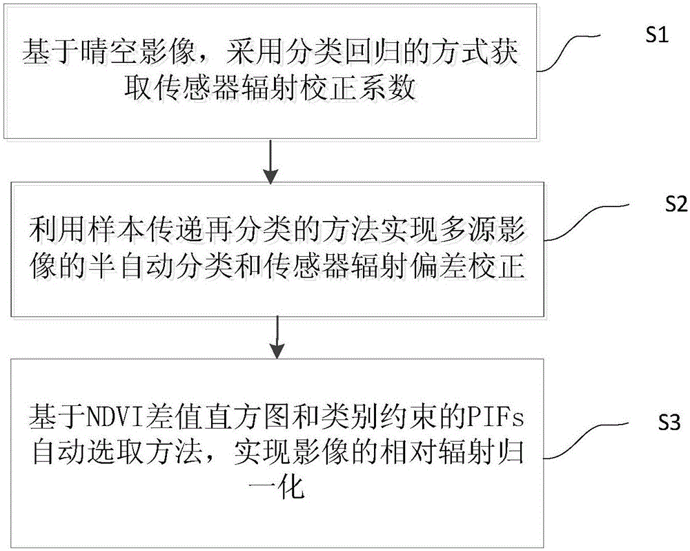
[0042] like figure 1 As shown, a multi-source remote sensing image radiation normalization method, which divides the relative radiation normalization of multi-source remote sensing images into two processes: sensor radiation correction and radiation normalization for external factors such as illumination;

[0043] Step S1. In remote sensing classification, sample quality is closely related to classification accuracy. In order to ensure high "fidelity" of sample information, samples are generally selected from images to be classified. When the same sample is applied to multi-scene images, differences in resolution, illumination, and time phase are likely to cause the phenomenon of the same object with different spectra, and the same spectrum with different objects, which brings greater uncertainty to the classification. Combined with the characteristics of continuous observation of the same area by time-series images; a semi-automatic classification method based on sample trans...


PUM


Abstract

The invention discloses a multi-source remote sensing image radiometric normalization method. The method is characterized in that relative radiometric normalization of a multi-source remote sensing image is divided into a sensor radiation correction process and a radiometric normalization process specific to external factors such as illumination. The method comprises the following steps: S1, acquiring a sensor radiation correction coefficient in a categorical regression way based on a clear sky image; S2, implementing semi-automatic classification and sensor radiation deviation correction of the multi-source image by a sample transmitting and reclassifying method; and S3, implementing relative radiometric normalization of the image through a PIFs (Pseudo Invariant Features) automatic selection method based on an NDVI (Normalized Difference Vegetation Index) histogram of differences and a category constraint. Through adoption of the multi-source remote sensing image radiometric normalization method, radiation deviations among sensors are effectively corrected, and higher radiometric normalization accuracy is achieved as a whole than a conventional method. Meanwhile, radiation feature fluctuation among time-sequence images can be eliminated effectively through the method, so that aspect change information of land such as vegetative can be expressed more accurately, and a reference method is provided for cooperative utilization of the multi-source time-sequence images.

Description

technical field [0001] The invention relates to the technical field of remote sensing images, in particular to a radiation normalization method for multi-source remote sensing images. Background technique [0002] The acquisition of remote sensing images is affected by factors such as the sensor itself, illumination, atmosphere, terrain, etc., resulting in great differences in the spectral characteristics of the same ground object on different images. Therefore, before using multi-source or multi-temporal remote sensing images for change detection or feature information extraction, it is necessary to perform radiation normalization processing on the images to control and reduce the variation of the surface landscape caused by differences in lighting conditions, atmospheric effects, and sensor responses. "Pseudo-change" retains real surface change information. [0003] There are two types of radiation normalization: absolute radiation normalization and relative radiation nor...

Claims


Application Information

Patent Timeline
Patent Type & Authority Applications(China)
IPC IPC(8): G06K9/62
CPCG06F18/24137G06F18/2415
Inventor 李丽
Owner INST OF REMOTE SENSING & DIGITAL EARTH CHINESE ACADEMY OF SCI
Why Eureka
Try Eureka