Full-3D occupation volume element landform modeling method based on laser radar

A technology of lidar and modeling method, which is applied in the application field and can solve the problems of terrain modeling uncertainty space description of three-dimensional terrain environment and so on.

Active Publication Date: 2017-01-18
SOUTHEAST UNIV
View PDF4 Cites 16 Cited by
  • Summary
  • Abstract
  • Description
  • Claims
  • Application Information

AI Technical Summary

Problems solved by technology

[0006] The purpose of the present invention is to propose a lidar-based full 3D occupancy voxel terrain modeling method to solve the uncertainty problem of terrain modeling in the full 3D occupancy voxel terrain modeling method based on uncertainty set representation, space Accuracy of description and efficiency of 3D terrain environment modeling to achieve accurate, efficient and real-time modeling of field terrain environment

Method used


Image

  • Full-3D occupation volume element landform modeling method based on laser radar
  • Full-3D occupation volume element landform modeling method based on laser radar
  • Full-3D occupation volume element landform modeling method based on laser radar

Examples


Embodiment Construction

[0079] The present invention will be further described below in conjunction with the accompanying drawings and specific embodiments.

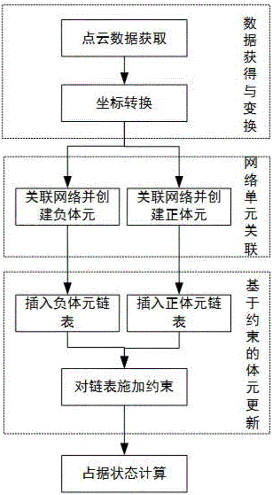
[0080] like figure 1 As shown, a lidar-based full 3D occupancy voxel terrain modeling method in the embodiment of the present invention includes the following steps:

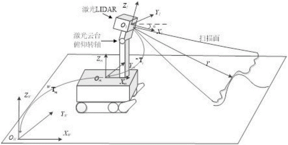
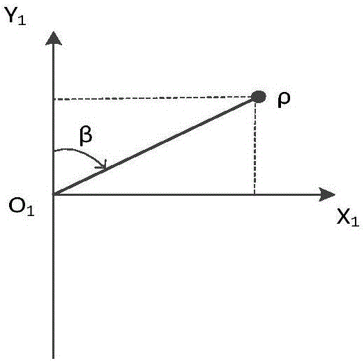
[0081] Step 10) Data acquisition and coordinate transformation: firstly, the laser radar equipment installed on the mobile robot platform is used to obtain the depth information of the surrounding environment; secondly, the coordinate transformation is used to convert the laser measurement data into point cloud data in the global coordinate system, and the The multi-source uncertainty in the measurement process is fused and processed by means of interval set members;

[0082] Step 20) Establish voxels: For the gap area from the start point to the end point of the ray, calculate the entry point and exit point of the grid it passes through according to the ray tracing algorithm, a...


PUM


Abstract

The invention discloses a full-3D occupation volume element landform modeling method based on a laser radar. The method comprises steps that step 10), data acquisition and coordinate transformation are carried out; 20), volume elements are established, for a gap area between a light start point and a terminal point, an incoming point and an outgoing point of a grid through which the gap area passes are calculated, negative volume elements are constructed to represent an idle state; for a terminal position area, the terminal position area is associated with multiple networks, and corresponding positive volume elements are constructed to represent an obstacle occupation state; step 30), on the basis of constrained volume element update, the constructed positive and negative volume elements are added to a present volume element linked list of the associated grid; update processing is then carried out; and step 40), an occupation state is calculated, probability of a volume element occupation state after update is calculated, and an occupation state is determined. Through the method, landform modeling nondeterminacy, space description accuracy and three-dimensional landform environment modeling efficiency problems can be solved, and precise, high-efficient and real-time field landform environment modeling is realized.

Description

technical field [0001] The invention belongs to the field of field operation robots, unmanned driving and other application fields, and in particular relates to a laser radar-based full 3D occupancy voxel terrain modeling method. Background technique [0002] In the field of autonomous navigation of unmanned platforms in outdoor environments, an accurate, efficient and robust 3D terrain model plays a vital role, directly determining the operating efficiency and overall economic benefits of the entire system. Different from the indoor environment, the outdoor environment has the characteristics of high dimensionality and complex structure, and the large-scale characteristics of the environment intensify the real-time contradiction of the terrain model. [0003] The perception of the spatial environment is the primary problem in 3D terrain modeling. Common perception methods include: binocular cameras, lidar, and ultrasonic ranging. During the working process of the binocula...

Claims


Application Information

Patent Timeline
Patent Type & Authority Applications(China)
IPC IPC(8): G01S17/89
CPCG01S17/89
Inventor 周波汤忠强马旭东戴先中
Owner SOUTHEAST UNIV
Why Eureka
Try Eureka