A Geosynchronous Orbit Constellation Orbit Determination Method Based on Ground Station/Inter-Satellite Link/GNSS Joint Measurement

An inter-satellite link and ground station technology, which is used in measurement devices, radio wave measurement systems, satellite radio beacon positioning systems, etc., can solve the trouble of GEO satellite precise orbit determination and forecasting, the relative position change is not obvious, and the distribution range Small and other problems, to achieve the effect of improving the relative positioning performance between satellites, improving the ability of autonomous operation, and reducing the amount of system calculation

Active Publication Date: 2019-03-12
BEIHANG UNIV +1
View PDF5 Cites 0 Cited by
  • Summary
  • Abstract
  • Description
  • Claims
  • Application Information

AI Technical Summary

Problems solved by technology

Compared with other orbit type satellites, there are greater difficulties in precise orbit determination of GSO satellites
[0003] There are certain limitations in the orbit determination of GSO satellites based on ground station measurement technology. (1) The "stationary" characteristics of GEO and the small distribution of IGSO satellite sub-satellite track areas with small inclination angles make it different from that of ground stations. The relative position changes are not obvious, and the observation geometry changes between satellite stations are very small, that is, the dynamic constraint information of the satellite relative to the ground station is weak. At this time, the effect of Doppler tracking is not obvious, and the amount of information brought by increasing the observation time is also limited. (2) When only ground stations within the territory of the country can be selected for satellite measurement and control, due to the relatively small deployment range and the high-orbit characteristics of GSO, the strength of the observation geometric structure formed between satellites and ground stations is quite poor, which will lead to In the process of estimating satellite orbit parameters, the observation equation may be ill-conditioned, affecting the estimation accuracy
(3) In order to keep GEO satellites geosynchronous, it is necessary to implement frequent maneuver control, which also brings great troubles to the determination and prediction of GEO satellites' precise orbits
[0005] At present, there are few domestic researches on high-orbit satellite constellation comprehensive utilization of satellite-earth, satellite-satellite and GNSS measurements to achieve orbit determination

Method used


Image

  • A Geosynchronous Orbit Constellation Orbit Determination Method Based on Ground Station/Inter-Satellite Link/GNSS Joint Measurement
  • A Geosynchronous Orbit Constellation Orbit Determination Method Based on Ground Station/Inter-Satellite Link/GNSS Joint Measurement
  • A Geosynchronous Orbit Constellation Orbit Determination Method Based on Ground Station/Inter-Satellite Link/GNSS Joint Measurement

Examples


Embodiment

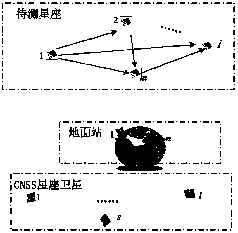
[0139] Taking a GSO constellation as an example, the constellation consists of 3 IGSO satellites and 1 GEO satellite. Satellite numbers 1 to 3 are IGSO satellites, which use geosynchronous satellites with small orbit eccentricity (close to circular orbit) and small orbit inclination (small distribution of sub-satellite track areas); satellite 4 is a GEO satellite. It is found in the simulation that the orbit determination and relative positioning accuracy of each satellite in the constellation are similar, so this article only takes IGSO numbered 1 as an example to illustrate.

[0140] Simulation conditions:

[0141] The high-precision orbit predictor (HPOP) in the STK software is used to generate real orbit data during the operation of the constellation to simulate the actual operation of the constellation.

[0142] (1) STK simulation parameter setting

[0143] The simulation time is from 00:00:00 on January 1, 2013 to 00:00:00 on January 2, 2013; it lasts one orbital perio...


PUM


Abstract

The invention discloses a geosynchronous orbit constellation orbit determination method based on ground station / satellite link / GNSS combined measurement. The method comprises the steps of (1) establishing the state equation of a GSO constellation orbit determination system in a centralized structure, (2) establishing the measurement equation of the GSO constellation orbit determination system in a centralized structure, (3) carrying out combined optimization of a ground station for orbit determination and GNSS measurement combination, (4) determining the filtering method for realizing orbit parameter estimation according to the above established GSO constellation combined orbit determination system model based on ground station / satellite link / GNSS, and (5) carrying out the concrete realization of a GSO constellation orbit determination method based on ground station / satellite link / GNSS in the centralized structure. According to the method, the combined distribution optimization strategy of ground station and GNSS measurement is established based on a precision factor, and the calculation amount is reduced while the orbit determination precision is ensured.

Description

technical field [0001] The invention belongs to the field of orbit determination of geosynchronous orbit satellite constellations, and specifically, is a satellite-to-ground, satellite-to-satellite and GNSS satellite-to-ground, satellite-to-satellite and GNSS measurement method obtained by effectively integrating and utilizing three measurement methods of ground station / inter-satellite link / GNSS. Measurement information to realize the joint orbit determination method of geosynchronous orbit satellite constellation. Background technique [0002] With the rapid development of aerospace technology, Geosynchronous Orbit Satellite (GSO) constellations have been widely used in the fields of navigation and positioning, timing, communication and reconnaissance. High-precision satellite orbit determination technology is an important prerequisite for the realization of the overall function and performance of the constellation. Geostationary Earth Orbits (GEO) satellites and Inclined ...

Claims


Application Information

Patent Timeline
Patent Type & Authority Patents(China)
IPC IPC(8): G01S19/37G01C21/24
CPCG01C21/24G01S19/37
Inventor 杨静张晓曼
Owner BEIHANG UNIV
Why Eureka
Try Eureka