Power channel corridor routing-inspection method based on tilt photography three-dimensional reconstruction technology

A technology of oblique photography and 3D reconstruction, applied in photogrammetry/video surveying, electromagnetic wave re-radiation, radio wave measurement system, etc., can solve the problems of lack of application basis, high inspection cost, poor timeliness, etc. The effect of safe operation

Active Publication Date: 2017-02-22
航天图景(北京)科技有限公司
View PDF4 Cites 57 Cited by
  • Summary
  • Abstract
  • Description
  • Claims
  • Application Information

AI Technical Summary

Problems solved by technology

The estimation of the distance of the tree to the wire mainly relies on the visual inspection method of the inspectors to mentally calculate the distance from the sag to the top of the tree. It needs to be observed from various angles. However, due to the influence of distance and angle, this method has a great influence of artificial observation angle and illusion , cannot accurately evaluate its distance
[0004] In addition, some power grid companies have introduced large-scale laser radar systems to quantitatively measure and identify defects in transmission line corridors. However, due to the high cost of laser radar systems, high inspection costs, and long inspection periods, inspections often take many years. Therefore, Poor timeliness
[0005] At present, there are also miniaturized lidar systems on the market. Although their prices have dropped from tens of millions to several million, their costs are still high compared to manual inspections. In addition, which mode to use is still lacking in power line inspections. Reliable Application Basis

Method used


Image

  • Power channel corridor routing-inspection method based on tilt photography three-dimensional reconstruction technology
  • Power channel corridor routing-inspection method based on tilt photography three-dimensional reconstruction technology
  • Power channel corridor routing-inspection method based on tilt photography three-dimensional reconstruction technology

Examples


Embodiment Construction

[0034] The following describes the power channel corridor inspection method based on the oblique photography three-dimensional reconstruction technology of the present invention in further detail with reference to the accompanying drawings and the embodiments of the present invention.

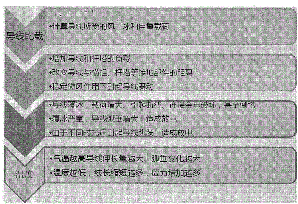
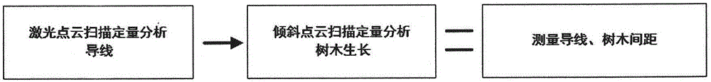
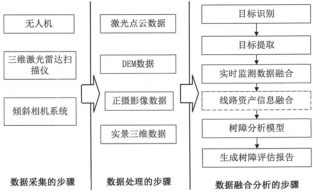
[0035] In recent years, oblique photography technology has gradually become a high-tech in the field of international remote sensing and mapping. Aerial oblique images can not only truly reflect the situation of ground objects, but also greatly expand the application field of remote sensing images by adopting advanced positioning technology, embedding accurate geographic information, richer image information, and more advanced user experience. The industry application of imaging is more in-depth. At the same time, the 3D model of the reconstructed target area can be quickly produced, which has gradually replaced the traditional manual modeling and has become an important way of new target 3D re...


PUM


Abstract

The invention discloses a power channel corridor routing-inspection method based on a tilt photography three-dimensional reconstruction technology, wherein the method includes the steps: A, combining a laser radar data measurement technology and a tilt photography technology, and rapidly constructing power transmission line channel high-precision three-dimensional base map data by using the laser radar measurement technology; B, acquiring three-dimensional real scene data of a channel corridor by using the tilt photography measurement technology; and C, carrying out fused analysis of the three-dimensional real scene information and a laser radar channel base map, effectively identifying and extracting trees and obstacles in the channel corridor, and then generating a tree barrier assessment report. By using the method, qualitative analysis of the tree barrier can be effectively turned into quantitative analysis, the position of a to-be-felled tree in the channel can be calculated, the felling area is statistical, and thus the safe operation of the line corridor is ensured.

Description

technical field [0001] The invention relates to a corridor inspection technology for overhead transmission lines, in particular to a power channel corridor inspection method based on a three-dimensional reconstruction technology of oblique photography. Background technique [0002] The inspection of corridor passages of overhead transmission lines is currently mainly based on manual inspections, manned helicopter inspections and drone inspections, mainly focusing on inspections of the defects of the lines themselves and external forces of the passages. However, whether it is manual inspection, manned helicopter inspection or drone inspection, most of them use visible light, infrared cameras or cameras to obtain image and video data, and can only qualitatively identify defects and faults (biased for defects in towers and wires). Qualitative identification), and quantitative identification cannot be achieved. [0003] There is also an overhead transmission line defect that re...

Claims


Application Information

Patent Timeline
Patent Type & Authority Applications(China)
IPC IPC(8): G01C11/00G01S17/88
CPCG01C11/00G01S17/88
Inventor 高小伟
Owner 航天图景(北京)科技有限公司
Why Eureka
Try Eureka