Method for measurement and calculation of correlation between urban form and carbon emission based on Landsat TM (Thematic Mapper) and ETM (Enhanced Thematic Mapper) images

A related relationship and carbon emission technology, applied in the research field of urban space planning and management, can solve the problems of not considering the series of urban resource and environmental effects, not involving urban compact development, and not conducive to urban carbon emission reduction and low-carbon development, etc. Realistic operability and practicability, overcoming subjective arbitrariness, easy to understand and generalize the effect

Inactive Publication Date: 2017-02-22
INST OF GEOGRAPHICAL SCI & NATURAL RESOURCE RES CAS
View PDF6 Cites 11 Cited by
  • Summary
  • Abstract
  • Description
  • Claims
  • Application Information

AI Technical Summary

Problems solved by technology

However, due to the blindness of urban growth (expansion) and the messiness of urban land use, existing technical methods have obvious limitations in application
This limitation is manifested in two aspects. First, it is not comprehensive enough, without considering the smart growth of the city, and the series of resource and environmental effects brought about by the expansion of the city; second, it does not involve the compact development of the city and how to optimize it through urban planning. Spatial Expansion Structure
These deficiencies restrict further research on the optimization of urban spatial structure, which is not conducive to urban carbon emission reduction and low-carbon development.

Method used


Image

  • Method for measurement and calculation of correlation between urban form and carbon emission based on Landsat TM (Thematic Mapper) and ETM (Enhanced Thematic Mapper) images
  • Method for measurement and calculation of correlation between urban form and carbon emission based on Landsat TM (Thematic Mapper) and ETM (Enhanced Thematic Mapper) images
  • Method for measurement and calculation of correlation between urban form and carbon emission based on Landsat TM (Thematic Mapper) and ETM (Enhanced Thematic Mapper) images

Examples


Embodiment Construction

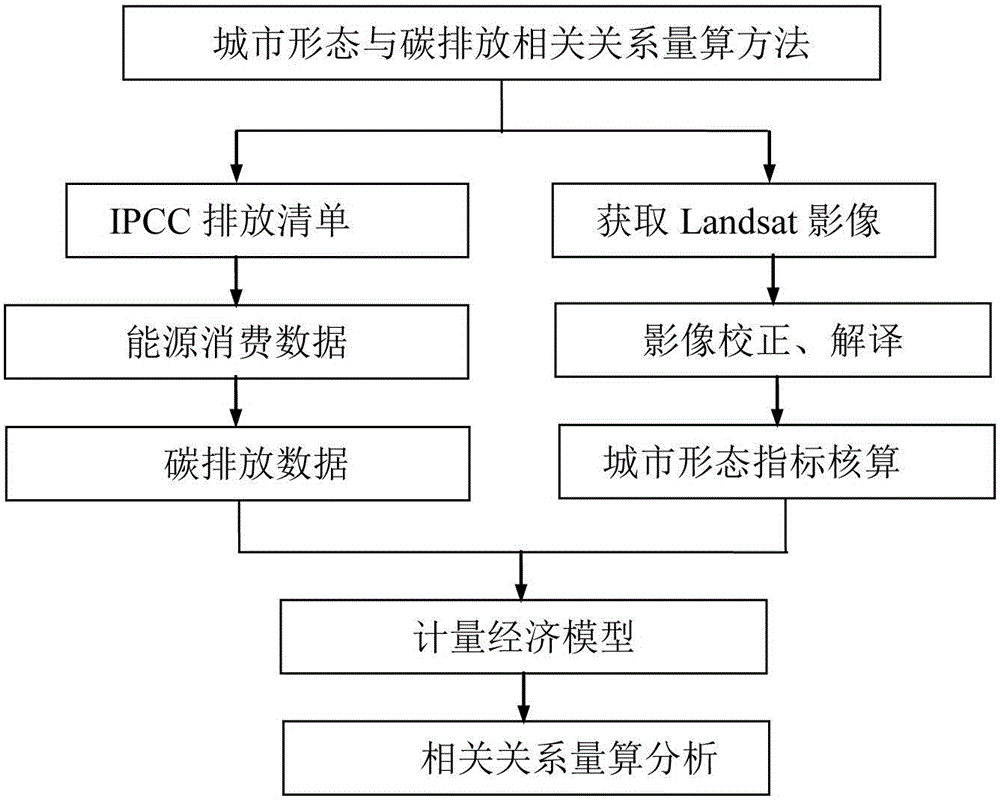
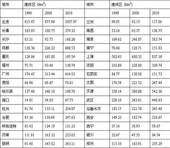
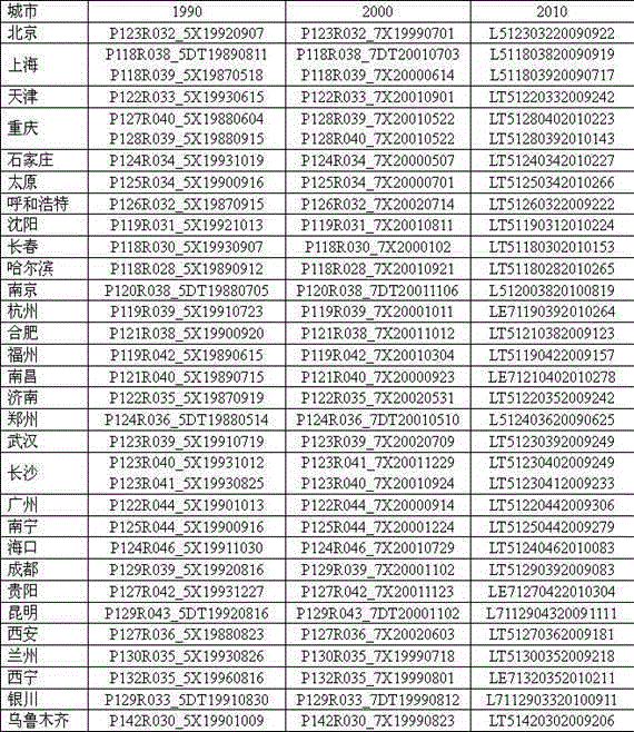
[0040] The specific application of the technical method of the present invention is further described by taking the calculation of the relationship between urban forms and carbon emissions of 30 provincial capital cities in the country as an example.

[0041] Taking 30 provincial capital cities across the country as the implementation case areas, estimate the carbon emissions of energy consumption based on the IPCC greenhouse gas emission inventory compilation method, and analyze the change trend of carbon emissions from 1990 to 2010; then based on Landsat TM and ETM images, with the help of related software and methods Calculate the urban form-related indicators of 30 provincial capital cities across the country; finally, based on the econometric model, quantitatively reveal the correlation between urban form and carbon emissions. Specifically, the application includes the following steps:

[0042] 1. Carbon emission accounting of 30 provincial capital cities across the count...


PUM


Abstract

The invention provides a technical method for quantitatively evaluating measurement and calculation of a correlation between an urban form and carbon emission based on Landsat TM (Thematic Mapper) and ETM (Enhanced Thematic Mapper) images. The method comprises the main steps of: 1, calculating urban energy consumption carbon emission based on an IPCC (Intergovernmental Panel on Climate Change) greenhouse gas emission inventory compilation method and various types of energy statistic data; 2, based on the Landsat TM and ETM images, quantitatively calculating urban form indexes by use of ENVI (Environment for Visualizing Images) / IDL (Interactive Data Language) 5.1 software and ArcGIS (Geographic Information System) 10.1 (ERSI) software; and 3, quantitatively calculating the correlation between the urban form-related indexes and carbon emission by use of an econometric model. The technical method is systematic, comprehensive and operable, and can provide an overall, objective and scientific optimized decision and regulation-control basis for urban spatial structure optimization.

Description

technical field [0001] The invention belongs to the field of urban spatial planning and management research. Specifically, the invention relates to a technical method for quantitatively calculating the relationship between urban form and carbon emissions. and scientific basis for decision-making. Background technique [0002] As an important spatial carrier of human production and life, cities are the most important regional unit of carbon emissions. On the one hand, cities occupy only 3% of the earth's surface, but consume 75% of the world's energy and emit 80% of the world's greenhouse gases. Cities, on the other hand, have led to global economic growth and improved living standards. Therefore, while city governments and planners are trying their best to promote urban economic growth, they are also facing enormous pressure to reduce emissions. Reducing carbon emissions from energy consumption and maintaining stable economic growth is a huge challenge for all city govern...

Claims


Application Information

Patent Timeline
Patent Type & Authority Applications(China)
IPC IPC(8): G06F17/50
Inventor 方创琳王少剑
Owner INST OF GEOGRAPHICAL SCI & NATURAL RESOURCE RES CAS
Why Eureka
Try Eureka