Terrain elevation sampling point encryption method taking morphology accuracy into account

A technology of terrain elevation and encryption method, which is applied in the directions of height/level measurement, image data processing, measurement device, etc., can solve problems such as distortion of terrain expression, and achieve the effect of improving data accuracy and high portability

Active Publication Date: 2017-03-15
CHUZHOU UNIV
View PDF3 Cites 16 Cited by
  • Summary
  • Abstract
  • Description
  • Claims
  • Application Information

AI Technical Summary

Problems solved by technology

This technical solution covers two key technical links, linear elevation sampling point encryption with adaptive surface morphology and regional elevation sampling point

Method used


Image

  • Terrain elevation sampling point encryption method taking morphology accuracy into account
  • Terrain elevation sampling point encryption method taking morphology accuracy into account
  • Terrain elevation sampling point encryption method taking morphology accuracy into account

Examples


Embodiment

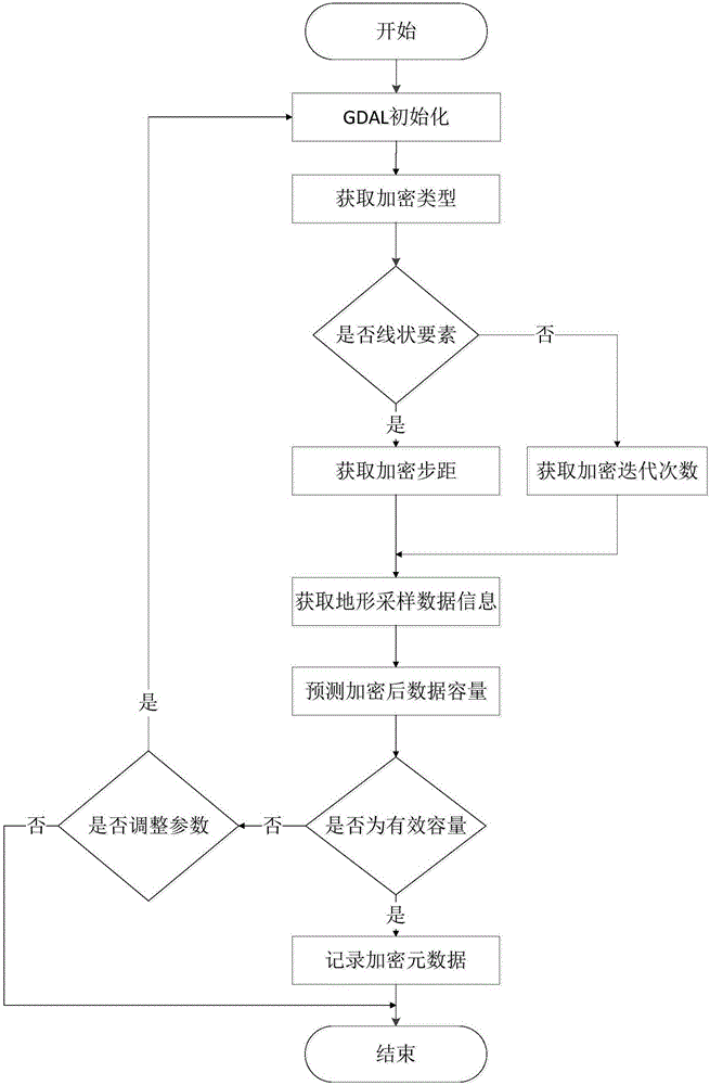
[0089] The following is an example of the encryption of elevation sampling points of urban terrain (roads and urban plots).

[0090] Urban DEM is the basic support for realizing 3D visualization, analysis, and planning of cities. Urban DEM digitally expresses surface morphology through limited sampling data. The core of its construction is the acquisition of urban surface geometric information and semantic information, that is, morphological information, that is, the acquisition of urban terrain sampling data. Among these sampling data, elevation sampling points are the most important and direct terrain data, which play a key and core role in urban terrain modeling. The urban terrain is divided by the road skeleton network, and is composed of two modules: urban roads and urban plots. Urban roads are defined as urban roads of secondary trunk roads and above (according to the "Code for Urban Road Engineering Design"), and urban plots It is a patch area surrounded by urban roads...


PUM


Abstract

The invention discloses a terrain elevation sampling point encryption method taking morphology accuracy into account. The terrain elevation sampling point encryption method taking morphology accuracy into account includes the following steps: 1, initializing encryption application information; if the sampling point is determined as a linear element elevation sampling point, executing the second step; and if the sampling point is determined as an area elevation sampling point, executing the third step; 2, executing a linear element elevation sampling point encryption module, and according to the encryption step pitch, performing encryption processing on the linear element elevation sampling point; 3, executing an area elevation sampling point encryption module, and according to the encryption iteration frequency, performing encryption processing on the area elevation sampling point; and 4, generating an elevation sampling point encryption result file: recycling the memory applied during the encryption process and wiping the temporary external storage data; and updating the log file, counting and recording the encryption metadata information. The terrain elevation sampling point encryption method taking morphology accuracy into account can effectively solve the problem that terrain expression is distorted because of insufficient elevation sampling points during high precision terrain modeling process.

Description

technical field [0001] The invention belongs to the technical field of terrain elevation sample point encryption (that is, sparse sample points are converted into dense sample points), relates to the encryption of linear element elevation sampling points and regional elevation sampling point encryption, and in particular proposes the elevation sampling point encryption that takes into account the shape constraints of terrain elements Strategy. Background technique [0002] Digital Elevation Model (DEM for short) is the core content of national basic geographic data. At present, my country has initially completed the construction of 1:1 million, 1:250,000, 1:50,000 and 1:10,000 DEM data in some areas. These data play an indispensable and important role in the national economy, national defense construction and scientific research. Its application fields cover many fields such as surveying and mapping, transportation, military, water conservancy, agriculture, environment, res...

Claims


Application Information

Patent Timeline
IPC IPC(8): G06T17/05G01C5/00
CPCG01C5/00G06T17/05
Inventor 江岭赵明伟王春杨灿灿张鲜鲜
Owner CHUZHOU UNIV
Why Eureka
Try Eureka