Method for analyzing space distribution feature of ground rainfall runoff pollution based on GIS (Geographic Information System) technology

A technology of spatial distribution and technical analysis, applied in the field of analyzing the spatial distribution characteristics of rainfall runoff pollution based on GIS technology, can solve the problem of low accuracy of calculation results

Active Publication Date: 2017-03-22
SHANGHAI MUNICIPAL ENG DESIGN INST GRP
View PDF4 Cites 8 Cited by
  • Summary
  • Abstract
  • Description
  • Claims
  • Application Information

AI Technical Summary

Problems solved by technology

[0005] The purpose of the present invention is to provide a method based on GIS technology to analyze the spatial distribution characteristics of rainfall runoff pollution, adopt GIS technology (geographic information system) to simulate the spatial distribution characteristics of rainfall runoff pollution, and solve the current output coefficient of single assignment based on land use type The problem of low accuracy of calculation results caused by the method, and provide scientific guidance for effectively formulating rainfall runoff pollution control strategies, implementing pollution control measures, and developing sponge city construction

Method used


Image

  • Method for analyzing space distribution feature of ground rainfall runoff pollution based on GIS (Geographic Information System) technology
  • Method for analyzing space distribution feature of ground rainfall runoff pollution based on GIS (Geographic Information System) technology
  • Method for analyzing space distribution feature of ground rainfall runoff pollution based on GIS (Geographic Information System) technology

Examples


Embodiment Construction

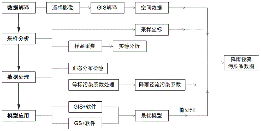
[0038] Below in conjunction with accompanying drawing and concrete implementation process, the patent of the present invention is described further.

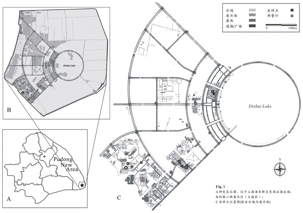
[0039] In order to better illustrate the specific implementation scheme of the patent of the present invention, the application of the method adopted in the present invention in Shanghai Lingang New City is taken as an example to illustrate the implementation process of the content of the present invention.

[0040] Shanghai Lingang New City is located in the southeast corner of Shanghai. 45% of its land area is formed by land reclamation. The soil has high salinity and the growth of transplanted plants is limited. The center of the main urban area of ​​Lingang New City is Dishui Lake, which is the largest in the world. artificial landscape lake with an area of ​​5.56km 2 , and the "Three Ripples" along the lake (Neilian River, Zhonglian River,

[0041] Wailian River) and "Seven Shots" constitute the main structure of the Lingang...


PUM


Abstract

The invention relates to a method for analyzing a space distribution feature of ground rainfall runoff pollution based on a GIS (Geographic Information System) technology. The method comprises the following steps: acquiring space information data of a land area in a research area; performing sampling and analyzing; preprocessing detection data of rainfall runoff pollution and establishing a database; building an optimal GIS model; and generating a space distribution map of rainfall runoff pollution levels. In the method, the GIS technology is introduced into the analysis for the space distribution feature of the rainfall runoff pollution, so that faults caused by a subjective method are reduced. Meanwhile, the space distribution feature of the rainfall runoff pollution is simulated by the GIS technology, so that the problem of relatively low accuracy of a calculation result due to a conventional export coefficient method in which single assignment is mainly performed according to the type of land use is solved, and scientific guidance is provided for the effective making of a rainfall runoff pollution control strategy, the implementation of a pollution control measure and the development of sponge city construction.

Description

technical field [0001] The invention relates to a method for analyzing the spatial distribution of rainfall runoff pollution, in particular to a method for analyzing the spatial distribution characteristics of rainfall runoff pollution based on GIS technology. Background technique [0002] In the 1970s, developed countries basically controlled point source pollution such as industrial wastewater and domestic sewage, and non-point source pollution has become the main source of natural water pollution. Relevant studies have shown that even if all point source pollution is controlled, good water environment quality cannot be guaranteed. The reason is that rainfall runoff washes away various pollutants on the ground and brings them into natural water bodies. Therefore, studying the spatial distribution characteristics of rainfall runoff pollution has direct guiding significance for formulating rainfall runoff pollution control strategies and implementing pollution control measur...

Claims


Application Information

Patent Timeline
Patent Type & Authority Applications(China)
IPC IPC(8): G06F17/30G06Q50/26
CPCG06F16/29G06Q50/26Y02A90/10
Inventor 吕永鹏谢胜张辰陈嫣莫祖澜尹冠霖
Owner SHANGHAI MUNICIPAL ENG DESIGN INST GRP
Why Eureka
Try Eureka