Supercharge Your Innovation With Domain-Expert AI Agents!

Urban underground pipeline geographic information system

A technology of geographic information system and underground pipeline, applied in the field of urban underground pipeline geographic information system, can solve the problems of not being able to provide useful help to users, lack of first-hand on-site data, and lack of information.

Pending Publication Date: 2017-04-05
TIANJIN JUHUI DATA TECH CO LTD
View PDF2 Cites 20 Cited by
  • Summary
  • Abstract
  • Description
  • Claims
  • Application Information

AI Technical Summary

Problems solved by technology

[0003] However, the traditional geographical information system of urban underground pipelines (referred to as urban power grid GIS system, and other urban pipelines) geographic information system has a lot of problems and cannot meet the management needs
[0004] Taking the urban power grid GIS system as an example, the main problem of the existing urban power grid GIS system is that the existing urban power grid GIS system has a small amount of information and does not show the topological relationship between the cable well and the cable corridor
The cable well in the existing urban power grid GIS system is just a label, which only tells the user where the cable well is roughly located. It does not establish a topological relationship between the cable and the cable trench, the cable well, etc., and cannot reflect the inside of the cable well or the cable trench. information
And the described position is also inaccurate, and there is no related description. When the user needs to go to a certain cable well for operation, the existing urban power grid GIS system cannot give the user beneficial help, and the user can only Rely on other information to determine the exact location of the cable well and find the cable well
Moreover, when users work in cable wells, they also cannot get any effective help from the existing urban power grid GIS system, and lack real and effective first-hand field data.
[0005] In addition, the existing urban grid GIS system does not manage the uniqueness and accuracy of cables
There is also no management of cable-related information in combination with cable listing

Method used


Image

  • Urban underground pipeline geographic information system
  • Urban underground pipeline geographic information system

Examples


Embodiment Construction

[0025] Typical embodiments embodying the features and advantages of the present invention will be described in detail in the following description. It should be understood that the present invention is capable of various changes in different embodiments without departing from the scope of the present invention, and that the description and drawings therein are illustrative in nature and not limiting. this invention.

[0026] An urban underground pipeline geographic information system for urban power grid underground cable and trench resource management according to a preferred embodiment of the present invention will be described in detail below.

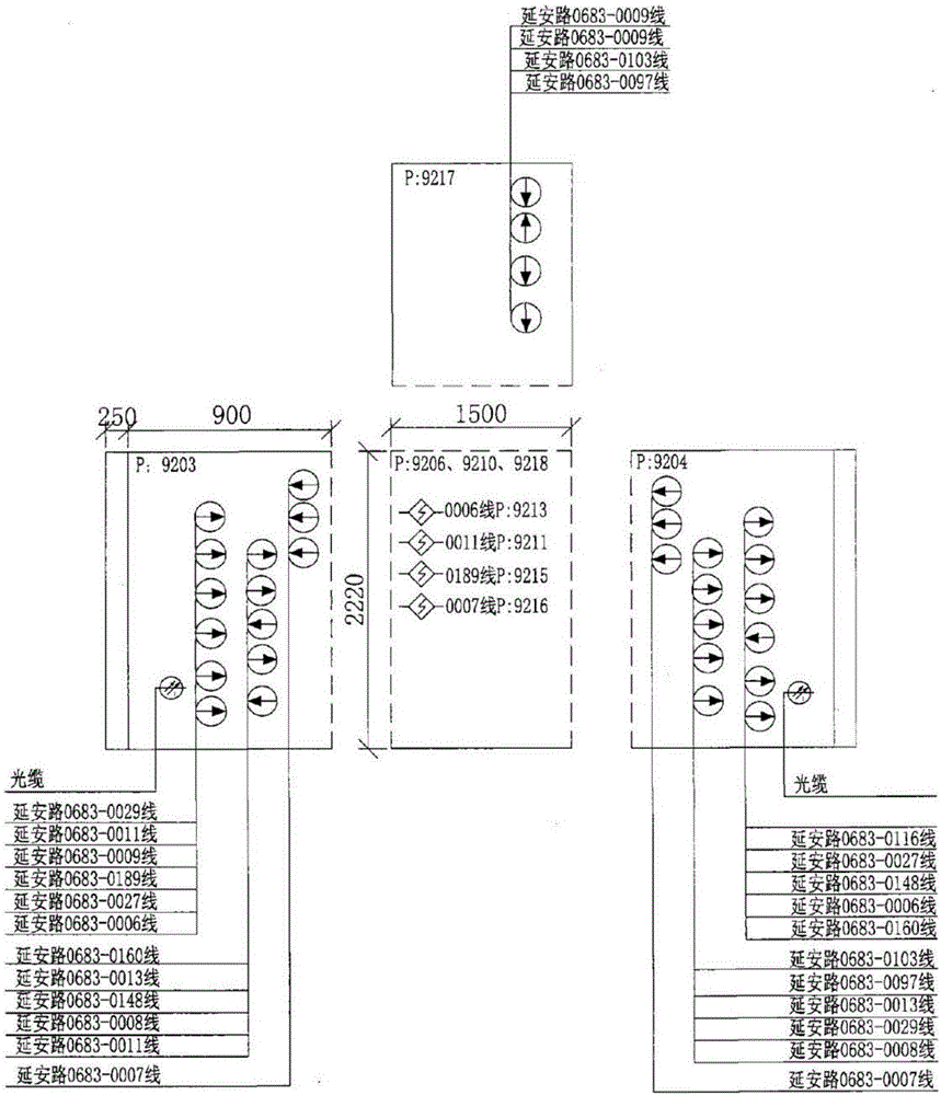
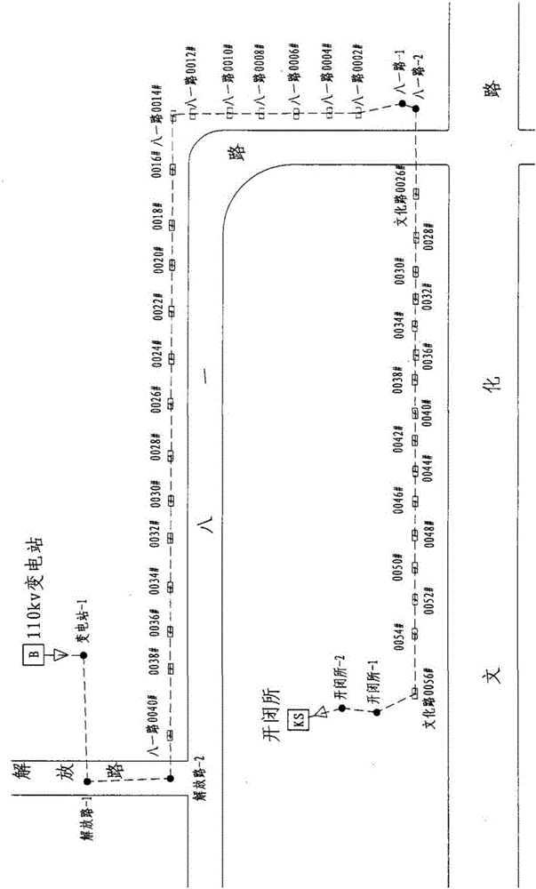
[0027] The urban underground pipeline geographic information system of the present invention mainly includes five modules, namely an electronic map module, a database module, a directory tree module, a trend map module and a display module, wherein the electronic map module and the display module are respectively used to generate ba...


PUM


Abstract

The invention discloses an urban underground pipeline geographic information system for management of an urban power grid and other pipeline underground resources. The urban underground pipeline geographic information system includes an electronic map module; a database module for establishing and maintaining a data base including cable information, cable well information, underground pipe ditch resource information, equipment information and transformer station information; a directory tree module for establish a directory tree step by step by using a transformer station as a unit; a direction map module for generating a direction map to describe a cable direction on a basic geographic information layer according to the directory tree, wherein a cable well identifier and a pipe ditch identifier in the direction map are associated with a corresponding section view; and a display module for showing the direction map of the cable. The urban underground pipeline geographic information system shows the user cables in the cable well and the topological relationship among the cables in the cable corridor in an intuitive way.

Description

technical field [0001] The invention relates to a geographic information system, in particular to a geographic information system for urban underground pipelines. Background technique [0002] With the development of modern cities, urban power grids and other municipal pipelines or lines. Pipelines, such as tap water, gas and other pipelines; lines, such as communication cables, cable TV cables, etc., the following urban municipal pipelines and lines are collectively referred to as urban pipelines. Urban pipeline resources are becoming more and more abundant, and management is becoming more and more difficult. How to intuitively present the cable corridor or other urban pipeline corridors, the direction, extension, cable wells or other urban pipeline pipeline wells, and the relationship between cable pipelines and other information has become a new topic. [0003] However, the traditional geographic information system of urban underground pipelines (referred to as urban po...

Claims


Application Information

Patent Timeline
IPC IPC(8): G06Q10/06G06Q50/06G06F17/30
CPCG06F16/29G06Q10/0631G06Q50/06
Inventor 李寿乐
Owner TIANJIN JUHUI DATA TECH CO LTD
Features
  • R&D
  • Intellectual Property
  • Life Sciences
  • Materials
  • Tech Scout
  • Unparalleled Data Quality
  • Higher Quality Content
  • 60% Fewer Hallucinations
Learn More