Remote scanning laser radar measurement error correction method

A measurement error, lidar technology, applied in measurement devices, radio wave measurement systems, re-radiation of electromagnetic waves, etc., can solve problems such as inability to calibrate instruments

Inactive Publication Date: 2017-04-26
BEIJING AEROSPACE INST FOR METROLOGY & MEASUREMENT TECH +1
View PDF3 Cites 27 Cited by
  • Summary
  • Abstract
  • Description
  • Claims
  • Application Information

AI Technical Summary

Problems solved by technology

[0005] The technical problem to be solved by the present invention is to solve the problem th

Method used


Image

  • Remote scanning laser radar measurement error correction method
  • Remote scanning laser radar measurement error correction method
  • Remote scanning laser radar measurement error correction method

Examples


Embodiment Construction

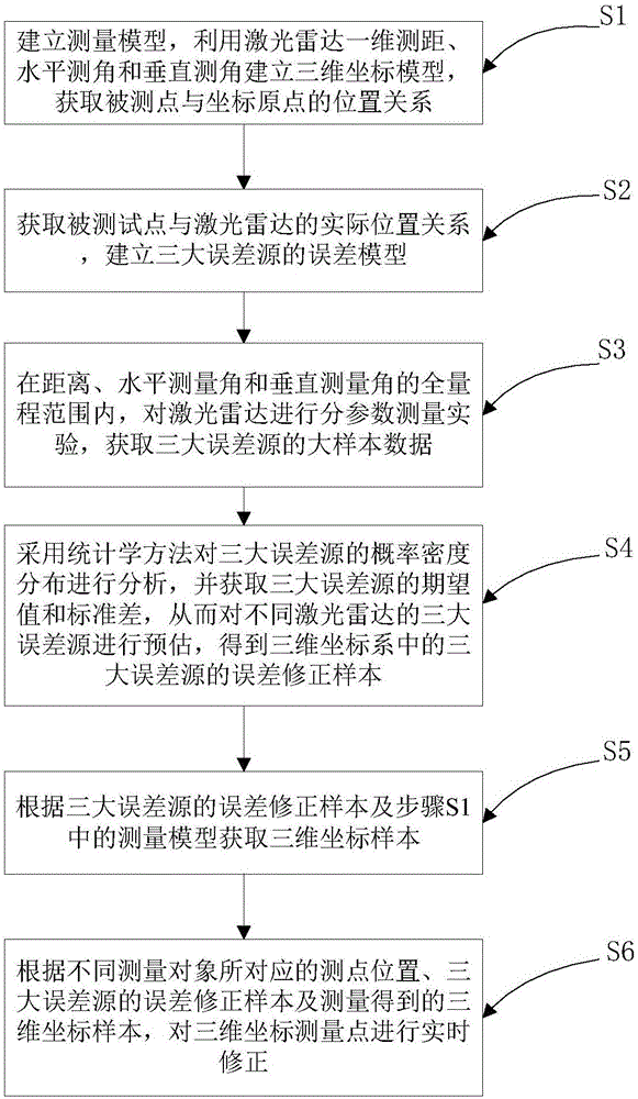
[0029] In order to make the purpose, technical solutions and advantages of the embodiments of the present invention clearer, the technical solutions in the embodiments of the present invention will be clearly and completely described below in conjunction with the drawings in the embodiments of the present invention. Obviously, the described embodiments It is a part of embodiments of the present invention, but not all embodiments. Based on the embodiments of the present invention, all other embodiments obtained by persons of ordinary skill in the art without making creative efforts belong to the protection scope of the present invention.

[0030] In the description of the present invention, it should be noted that unless otherwise specified and limited, the terms "installation", "connection" and "connection" should be understood in a broad sense, for example, it can be a fixed connection or a detachable connection. Connected, or integrally connected; it may be mechanically conn...


PUM


Abstract

The present invention relates to the radar measurement technology field, especially to a remote scanning laser radar measurement error correction method. The method comprises: the step S1, establishing a measurement model, and obtaining the position relation of a tested point and an origin of coordinates; the step S2, obtaining the real position relation of the tested point and the laser radar, and establishing the error model of three error sources; the step S3, performing the fractal parameter measurement experiment of the laser radar, and obtaining large sample data of the three error sources; the step S4, employing the statistical method to analyze the probability density distribution of the three error sources, and obtaining the error correction samples of the three error sources in the three-dimensional coordinate system; the step S5, obtaining the three-dimensional coordinate sample according to the error correction samples of the three error sources and the measurement model in the step S1; and the step S6, performing real-time correction of the three-dimensional coordinate measurement point according to the measurement point position corresponding to different objects, the error correction samples of the three error sources and the measured three-dimensional coordinate samples.

Description

technical field [0001] The invention relates to the technical field of radar measurement, in particular to a method for correcting measurement errors of long-distance scanning radar. Background technique [0002] Long-distance scanning lidar is a large-scale spatial coordinate measuring instrument, which is used to realize the scanning measurement of 3D point cloud data on the surface of large objects within the range of 100m to 1km. The measurement data is used as the basis for the subsequent reverse reconstruction of the digital model. The long-distance scanning laser radar belongs to the spherical coordinate measurement system. It realizes the three-dimensional coordinate measurement of the target point through the one-dimensional laser ranging and the angle measurement in the horizontal and vertical directions. The ranging unit can realize the distance measurement within 1km. Scanning in one direction realizes the acquisition of point cloud data. The accuracy of three-d...

Claims


Application Information

Patent Timeline
IPC IPC(8): G01S7/497
CPCG01S7/497G01S7/4808G01S17/42
Inventor 刘柯缪寅宵宋金城孙增玉董利军郭力振朱浩
Owner BEIJING AEROSPACE INST FOR METROLOGY & MEASUREMENT TECH
Why Eureka
Try Eureka