
Kriging space interpolation method based on multi-scale wavelet support vector machine optimization

A technology of support vector machine and spatial interpolation, which is applied in image data processing, instrumentation, calculation, etc., can solve the problems of ignoring the scale effect of spatial change, unable to reflect the spatial change trend of actual samples, and the shape of theoretical model is fixed.

Inactive Publication Date: 2017-04-26
CHINA UNIV OF PETROLEUM (EAST CHINA)
View PDF0 Cites 20 Cited by
  • Summary
  • Abstract
  • Description
  • Claims
  • Application Information

AI Technical Summary

Problems solved by technology

The traditional method can only use the existing theoretical variogram model to fit limited geographical space samples, but the existing theoretical model has a fixed shape and cannot reflect the spatial variation trend of the actual sample
Secondly, the spatial change trend often has the characteristics of multi-scale, and the choice of scale and the treatment of scale effects also need to be considered. The experimental variogram fitted only by traditional methods will ignore the scale effect of spatial change

Method used


Image

  • Kriging space interpolation method based on multi-scale wavelet support vector machine optimization
  • Kriging space interpolation method based on multi-scale wavelet support vector machine optimization
  • Kriging space interpolation method based on multi-scale wavelet support vector machine optimization

Examples


Embodiment

[0146] Example: SIC97 Dataset

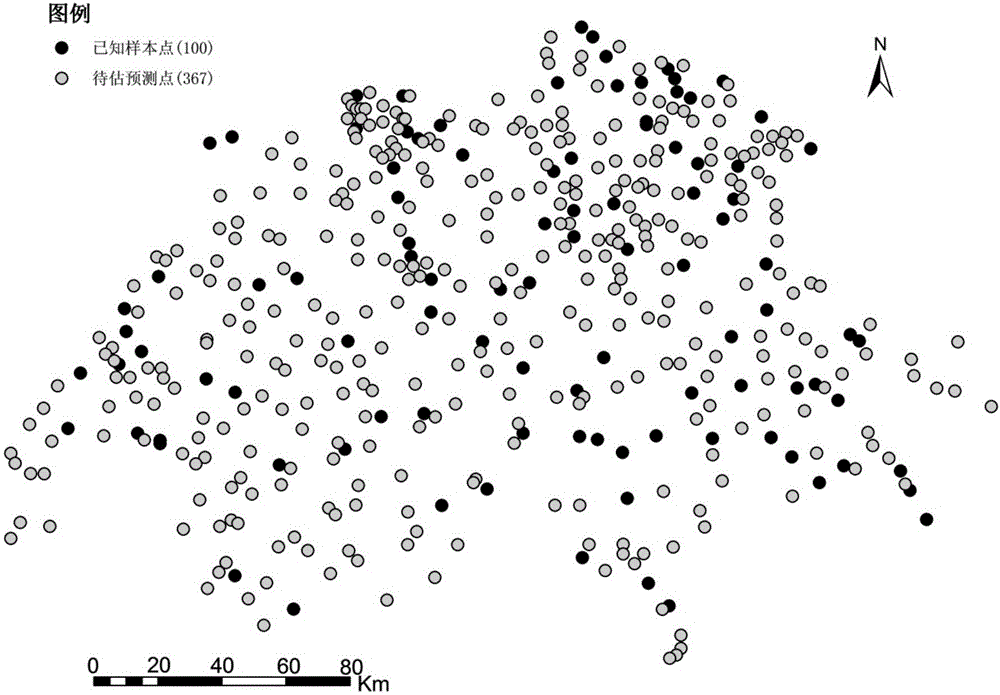
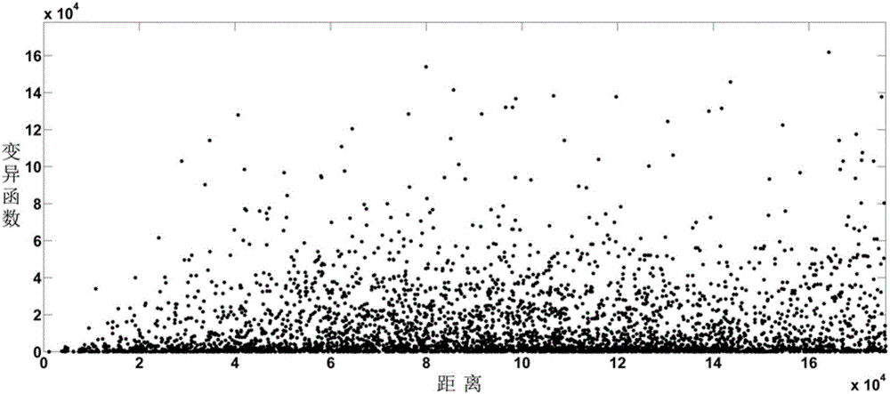
[0147] The Spatial Interpolation Comparison 97 data set (SIC97 data for short) is the precipitation data of 467 precipitation observation stations in Switzerland on May 8, 1986. Among them, the total number of sample observation stations is 100, that is, k=100, and the total number of points to be estimated is The number is 367, that is, S=367. Data Sources: https: / / www.researchgate.net / profile / Gregoire_Dubois / publication / 281292076_Spatial_I Interpolation_Comparison_97_ (SIC97)_dataset , interpolate the points to be estimated by known observation points, the distribution of observation points and points to be estimated is as follows figure 2 As shown, due to the large number of sample points, the grouping operation is performed before fitting the experimental variogram, and the total number of experimental variogram values ​​to be fitted after grouping is 20, that is, n=20, image 3 and Figure 4 Respectively represent the cloud diag...


PUM


Abstract

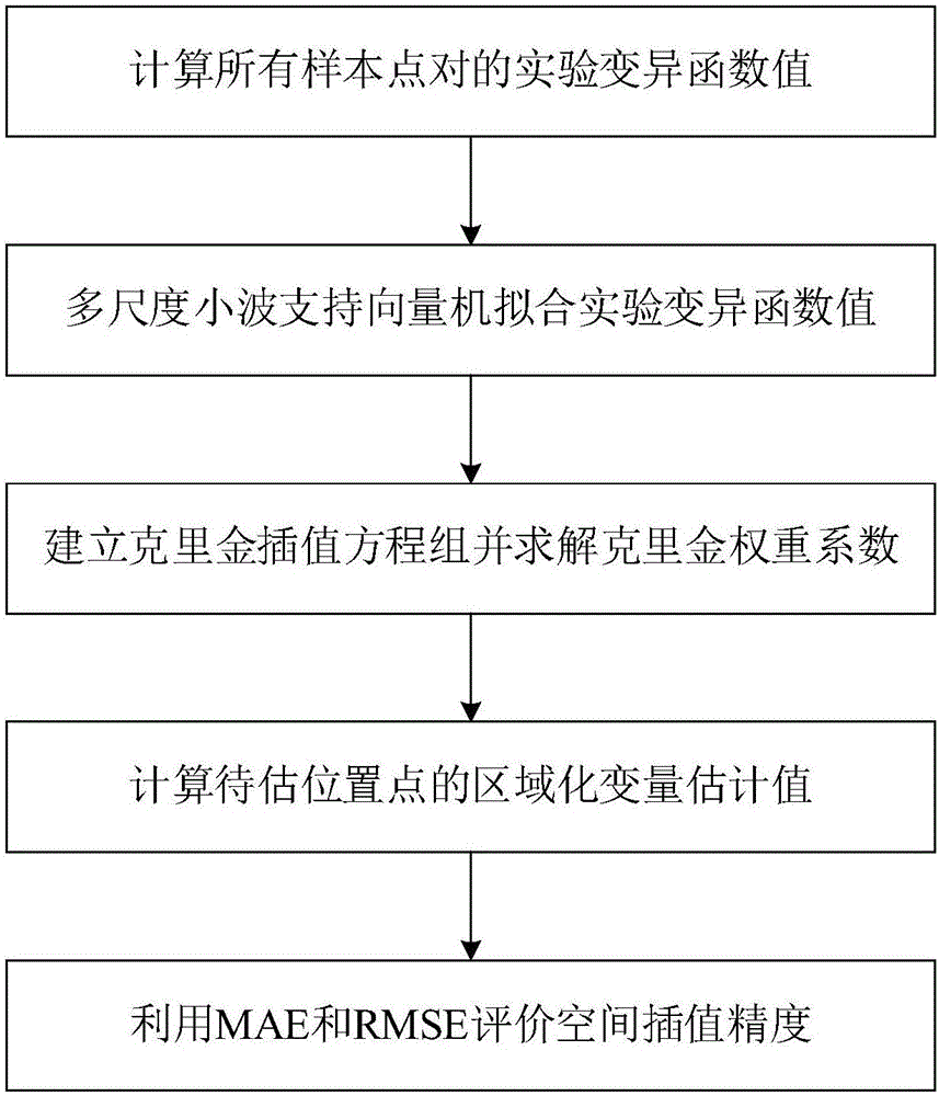
The invention discloses a Kriging space interpolation method based on multi-scale wavelet support vector machine optimization which comprises the following steps: using a discrete variation function formula to calculate the experimental variation function values of all sampling point pairs; using a multi-scale wavelet least squares support vector machine to fit the experimental variation function values to obtain a theoretical variation function model; establishing Kriging space interpolation equations; according to the theoretical variation function model, calculating the Kriging weight coefficient Lambda i; according to the Kriging weight coefficient Lambda i, calculating the regional variation amount estimation value of a to-be-estimated position point; based on the regional variation amount estimation value and the actual value of the to-be-estimated position point, using the mean absolute error (MAE) and the root mean square error (RMSE) to conduct interpolation accuracy evaluation. According to the invention, the optimized Krigine space interpolation method achieves a higher accuracy; therefore, it is possible to evaluate the attribute information of a to-be-estimated position point more accurately and to increase the capability of geographical data to interpret geographical space phenomenon.

Description

technical field [0001] The invention relates to the field of geographic space interpolation, in particular to a Kriging space interpolation method based on multi-scale wavelet support vector machine optimization. Background technique [0002] Geospatial interpolation is to estimate the attribute information of geospatial location points to be estimated based on the attribute information of known sample points. The essence of estimating the value of other arbitrary points or arbitrary partitions is to fit and generate a functional relationship that is as close as possible to the geographic spatial distribution characteristics through modeling. There are a wide variety of geographic spatial interpolation methods, commonly used include Thiessen polygon method, inverse distance weighting method, moving fitting method, linear interpolation method, spline function method, trend analysis method, kriging interpolation method, etc. Among them, the kriging interpolation method is als...

Claims


Application Information

Patent Timeline
IPC IPC(8): G06T3/40
CPCG06T3/4007
Inventor 王海起车磊陈冉桂丽刘玉闫滨翟文龙费涛
Owner CHINA UNIV OF PETROLEUM (EAST CHINA)
Learn More