Method for improving ocean gravity field interpolation precision based on submarine topography three-dimensional optimization principle

A technology of gravity field and gravity field model, applied in the cross field, can solve the problems of reduced precision and low resolution, and achieve the effect of reducing detection error

Pending Publication Date: 2021-01-15
CHINA ACADEMY OF SPACE TECHNOLOGY
View PDF3 Cites 10 Cited by
  • Summary
  • Abstract
  • Description
  • Claims
  • Application Information

AI Technical Summary

Problems solved by technology

At present, the spatial resolution of my country's global ocean gravity anomaly map is low, and the spatial resolution of the existing global ocean gravity anomaly map cannot meet the needs of global high-precision underwater gravity matching ...

Method used


Image

  • Method for improving ocean gravity field interpolation precision based on submarine topography three-dimensional optimization principle
  • Method for improving ocean gravity field interpolation precision based on submarine topography three-dimensional optimization principle
  • Method for improving ocean gravity field interpolation precision based on submarine topography three-dimensional optimization principle

Examples


Embodiment Construction

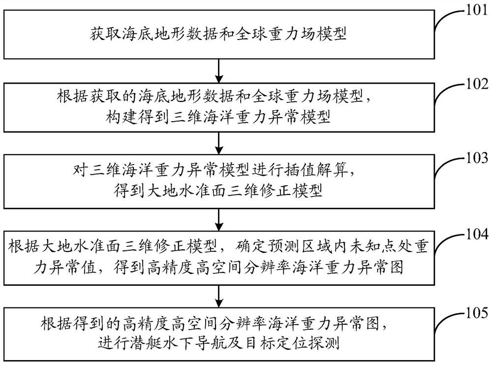
[0050] In order to make the object, technical solution and advantages of the present invention clearer, the embodiments disclosed in the present invention will be further described in detail below in conjunction with the accompanying drawings.

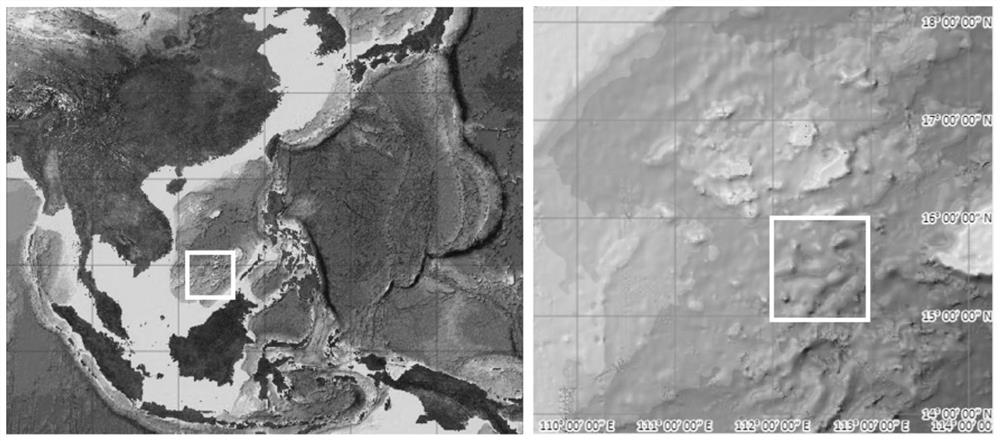
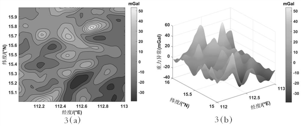
[0051] Different from the previous studies, the present invention aims to improve the spatial resolution of the global ocean gravity anomaly map while minimizing its accuracy loss, and integrates the existing high-spatial-resolution seabed topographic data into ordinary two-dimensional Kriging In the algorithm, a method based on the three-dimensional optimization principle of the seabed terrain is proposed to improve the interpolation accuracy of the ocean gravity field, aiming to obtain a high-spatial resolution global ocean gravity anomaly map with the least accuracy loss, thereby improving the accuracy of global underwater gravity matching navigation, and through actual measurement The data verified the reliability of the new three-d...


PUM


Abstract

The invention discloses a method for improving ocean gravity field interpolation precision based on a submarine topography three-dimensional optimization principle. The method comprises steps of submarine topography data and a global gravity field model being acquired; constructing a three-dimensional ocean gravity anomaly model according to the acquired submarine topographic data and the global gravity field model; performing interpolation calculation on the three-dimensional ocean gravity anomaly model to obtain a geoid three-dimensional correction model; and according to the geoid three-dimensional correction model, determining a gravity anomaly value at an unknown point in the prediction area to obtain a high-precision and high-spatial-resolution marine gravity anomaly map. According to the method, the submarine topography is introduced into a common two-dimensional Kriging formula, a novel submarine topography three-dimensional optimization method is constructed, the precision loss is minimized while the spatial resolution of the global marine gravity anomaly map is improved, the interpolation precision is high, the calculation speed is high, and an effective basis is providedfor improving the submarine gravity matching navigation precision.

Description

technical field [0001] The invention belongs to the interdisciplinary technical fields of marine gravity, underwater navigation and the like, and in particular relates to a method for improving the interpolation accuracy of the marine gravity field based on the three-dimensional optimization principle of the seabed topography. Background technique [0002] Submarines generally rely on inertial navigation systems to navigate underwater. The important components of inertial navigation systems are gyroscopes and accelerometers. The acceleration measured by these sensitive components can be integrated with time to obtain speed, yaw angle, position, etc. information. In the integration process, the error increases with time, and the navigation accuracy of the submarine will gradually decrease when the submarine operates underwater for a long time. In view of the shortcomings of the inertial navigation system, many scholars have proposed to combine passive navigation methods such...

Claims


Application Information

Patent Timeline
IPC IPC(8): G01C21/20G01V7/00G06T17/00
CPCG01C21/203G01V7/00G06T17/00
Inventor 郑伟李钊伟王彤吴凡
Owner CHINA ACADEMY OF SPACE TECHNOLOGY
Why Eureka
Try Eureka