Autonomous real-time airborne terrain-aided inertial navigation method and system

An inertial navigation system and a navigation method technology are applied in the field of autonomous real-time airborne terrain-aided inertial navigation methods and systems, which can solve the problems of limited carrier maneuvering flight and real-time positioning capabilities, and achieve the ability to solve the problem of limited navigation and real-time positioning capabilities. , the effect of ensuring reliability, improving capabilities

Active Publication Date: 2017-05-10
BEIHANG UNIV
View PDF5 Cites 22 Cited by
  • Summary
  • Abstract
  • Description
  • Claims
  • Application Information

AI Technical Summary

Problems solved by technology

[0003] The present invention provides a real-time airborne terrain-assisted navigation method and system to solve the problem that the current terrain-assisted navigation system needs to plan the flight route and select the matching area according to the flight mission in advance, so that the ability of the carrier's maneuvering flight and real-time positioning is limited.

Method used


Image

  • Autonomous real-time airborne terrain-aided inertial navigation method and system
  • Autonomous real-time airborne terrain-aided inertial navigation method and system
  • Autonomous real-time airborne terrain-aided inertial navigation method and system

Examples


Embodiment Construction

[0044]The technical solutions of the present invention will be clearly and completely described below in conjunction with the accompanying drawings of the present invention. Apparently, the described embodiments are only some of the embodiments of the present invention, not all of them. Based on the embodiments of the present invention, all other embodiments obtained by persons of ordinary skill in the art without making creative efforts fall within the protection scope of the present invention.

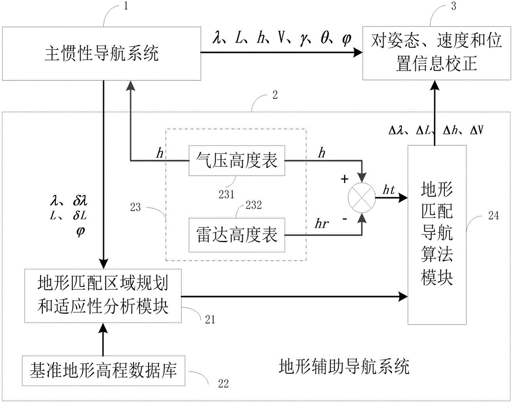
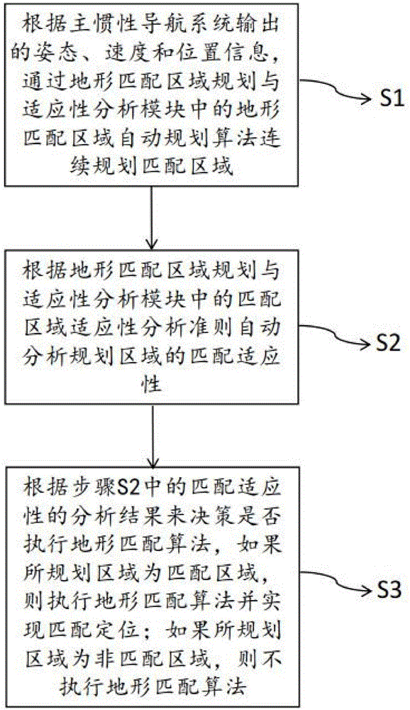
[0045] An example such as figure 1 The autonomous real-time airborne terrain-assisted inertial navigation system shown includes the main inertial navigation system 1 and the terrain-assisted navigation system 2 . Among them, the main inertial navigation system 1 provides the real-time attitude, velocity and position information of the carrier (the position information includes the estimated value of the position error); the terrain auxiliary navigation system 2 serves as the auxiliar...


PUM


Abstract

The invention discloses an autonomous real-time airborne terrain-aided inertial navigation method and system. The method comprises the following steps: according to attitude, speed and position information outputted from a main inertial navigation system, matching areas are continuously planned according to a terrain matching area automatic planning algorithm in a terrain matching area planning and adaptability analysis module; matching adaptability of planned areas is automatically analyzed according to matching area adaptability analysis criterion in the terrain matching area planning and adaptability analysis module; whether a terrain matching algorithm is executed is decided according to the analysis result of the matching adaptability, if the planned areas are the matching areas, the terrain matching algorithm is executed in order to realize the matching positioning; if the planned areas are not the matching areas, the terrain matching algorithm is not executed.

Description

technical field [0001] The invention relates to the technical field of navigation and positioning, in particular to an autonomous real-time airborne terrain-assisted inertial navigation method and system. Background technique [0002] Terrain Aided Navigation (TAN) has been widely valued and researched in integrated navigation systems due to its advantages of autonomy, concealment, strong anti-interference ability and all-weather work, and has been used in cruise missiles, aircraft and ships. Successfully applied on board. The positioning idea of ​​TAN is to use the terrain elevation data under the measured motion track and the stored digital terrain elevation model (Digital Elevation Model, DEM) as information, and use the terrain matching algorithm to achieve the purpose of positioning. The positioning accuracy and real-time performance of the terrain-assisted navigation system are not only related to the terrain matching algorithm but also affected by the terrain charact...

Claims


Application Information

Patent Timeline
Patent Type & Authority Applications(China)
IPC IPC(8): G01C21/16
CPCG01C21/165
Inventor 赵龙张且且
Owner BEIHANG UNIV
Why Eureka
Try Eureka