Method for obtaining geometrical parameters of typical terrains in digital map

A digital map and geometric parameter technology, applied in the field of geographic information system and computer graphics, can solve the problems of single research method, lack of overall geometric shape recognition, simplification and geometric parameter extraction of terrain.

Active Publication Date: 2017-05-10
XIDIAN UNIV
View PDF2 Cites 16 Cited by
  • Summary
  • Abstract
  • Description
  • Claims
  • Application Information

AI Technical Summary

Problems solved by technology

It can be seen that the existing research results have the following problems: (1) The research only involves the recognition of local geometric features such as special terrain points (such as mountain tops, saddle points), special lines (ridge lines, valley lines, and foot lines), and lacks Research on the recognition, simplification and geometric parameter extraction of the overall terrain geometry; (2) The research method is relatively simple, mainly based on geometric graphics, and the research of imagery methods is not fully utilized; (3) The slope, There are certain limitations in the research on terrain factors such as section curvature, tangent curvature, and terrain relief.

Method used


Image

  • Method for obtaining geometrical parameters of typical terrains in digital map
  • Method for obtaining geometrical parameters of typical terrains in digital map
  • Method for obtaining geometrical parameters of typical terrains in digital map

Examples


example

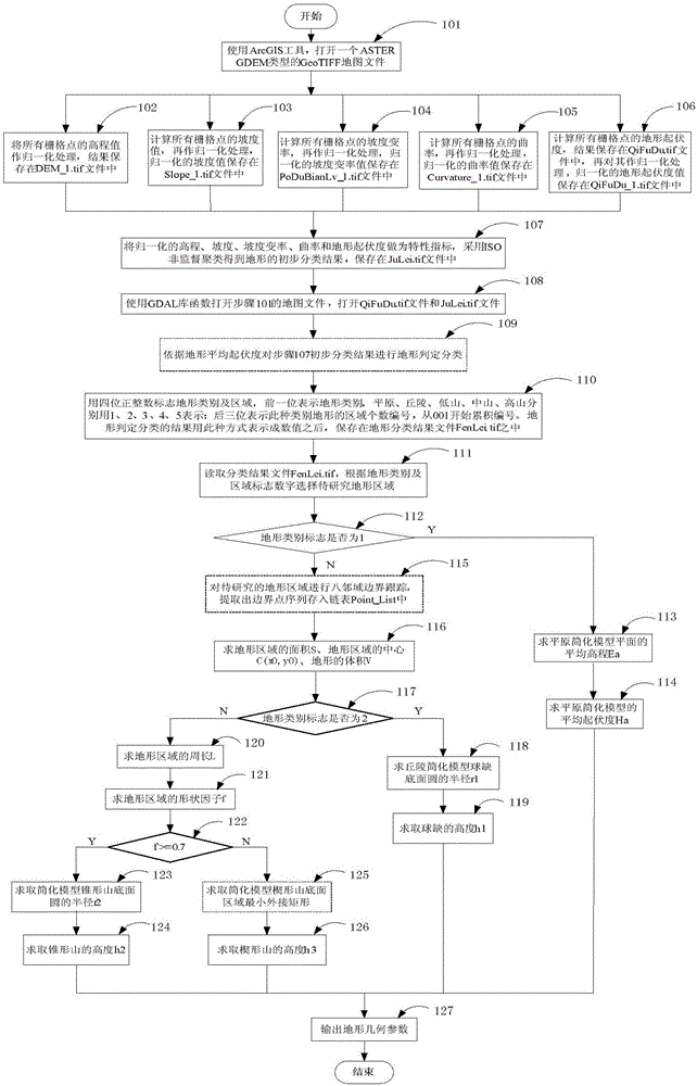
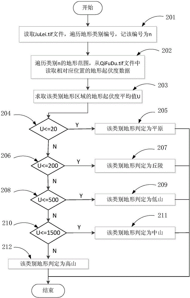
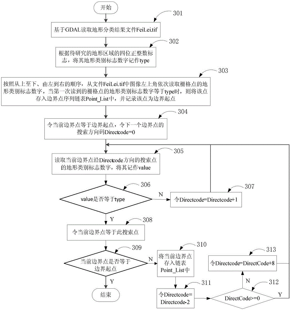
[0148] The invention is used to extract the geometric parameters of a domestic terrain named Gufeng Mountain. Figure 5 It is to read and process the DEM data of the isolated peak mountain and display the actual shape of the isolated peak mountain in grid form. By using the ArcGIS tool to calculate the normalized elevation, slope, slope variability, curvature, and terrain relief from the digital map file of the ASTER GDEM type GeoTIFF format where the Gufeng Mountain is located, and using it as a characteristic index, it is obtained by using ISO unsupervised clustering Preliminary classification of the terrain; then the preliminary classification results are classified according to the average relief of various terrains, and Gufeng Mountain is selected as the terrain area to be studied. Figure 6 It is the graphical result of the terrain area classification and boundary tracking extraction. There are two types of terrain: plain and mid-mountain. The length and shape factor ar...


PUM


Abstract

The invention relates to a method for obtaining geometrical parameters of typical terrains in a digital map. The method includes the steps of terrain classification and recognition, terrain simplification, extracting of the geometrical parameters of the terrains and the like. According to the digital map in the GeoTIFF format in the ASTER GDEM type, by means of an ArcGIS tool, the normalized elevation, the normalized gradient, the normalized gradient variability, the normalized curvature and the normalized terrain undulation are calculated, iterative selforganization (ISO) unsupervised clustering is carried out with the obtained parameters as characteristic indexes, and the preliminary classification of the terrains is obtained; then the terrains are classified into the plain, the hill, the low mountain, the medium mountain, the high mountain and the like according to the average undulation of the various terrains; the geometrical parameters such as the positions, the bottom faces and the heights of the typical terrains are finally obtained. The method has the advantages of being feasible and practical.

Description

technical field [0001] The invention belongs to the field of geographic information system (GIS) and computer graphics, and relates to a terrain classification method and a terrain parameter extraction and simplified model building method, specifically a method for obtaining typical terrain geometric parameters in a digital map, which can be used for large-scale terrain in the field Approximate calculation and fast real-time display of the electric wave propagation of the scene. Background technique [0002] With the rapid development of technologies such as computers and satellite remote sensing in recent years, a wave of digitalization is sweeping the world. The earth is the primary carrier of human activities and life. In the process of understanding nature and transforming nature, people have been trying to use different methods to describe and express the environmental information of the surrounding topography and landforms. Among many methods, the expression method of...

Claims


Application Information

Patent Timeline
Patent Type & Authority Applications(China)
IPC IPC(8): G06F17/30G06T7/13
Inventor 许社教叶松涛李杨邱扬田锦杜美玲赵泽张建国
Owner XIDIAN UNIV
Why Eureka
Try Eureka