Extraction Method of Terrain Geometric Parameters Based on Layered Elevation Cloud Image

An extraction method and a technology of geometric parameters, which are applied in the fields of images, geographic information systems and computer graphics, can solve the problems of low degree of automation, difficulty in guaranteeing the practicability of the method, lack of overall terrain geometric shape recognition, segmentation, simplification and geometric parameter extraction, etc. question

Active Publication Date: 2021-05-11
XIDIAN UNIV
View PDF5 Cites 0 Cited by
  • Summary
  • Abstract
  • Description
  • Claims
  • Application Information

AI Technical Summary

Problems solved by technology

It can be seen that the existing research results have the following problems: (1) The research only involves special terrain points (such as mountain tops, saddle points), special lines (ridge lines, valley lines, mountain lines, foot lines, defense boundaries) and other local areas. For the recognition of geometric features, there is a lack of research on the recognition, segmentation, simplification, and extraction of geometric parameters of the overall terrain geometry; (2) the research method has a low degree of automation due to some parameters manually set; (3) for the real-time application of terrain , there is no research on the limited range of terrain distance, and it is difficult to guarantee the practicability of the method

Method used


Image

  • Extraction Method of Terrain Geometric Parameters Based on Layered Elevation Cloud Image
  • Extraction Method of Terrain Geometric Parameters Based on Layered Elevation Cloud Image
  • Extraction Method of Terrain Geometric Parameters Based on Layered Elevation Cloud Image

Examples


example

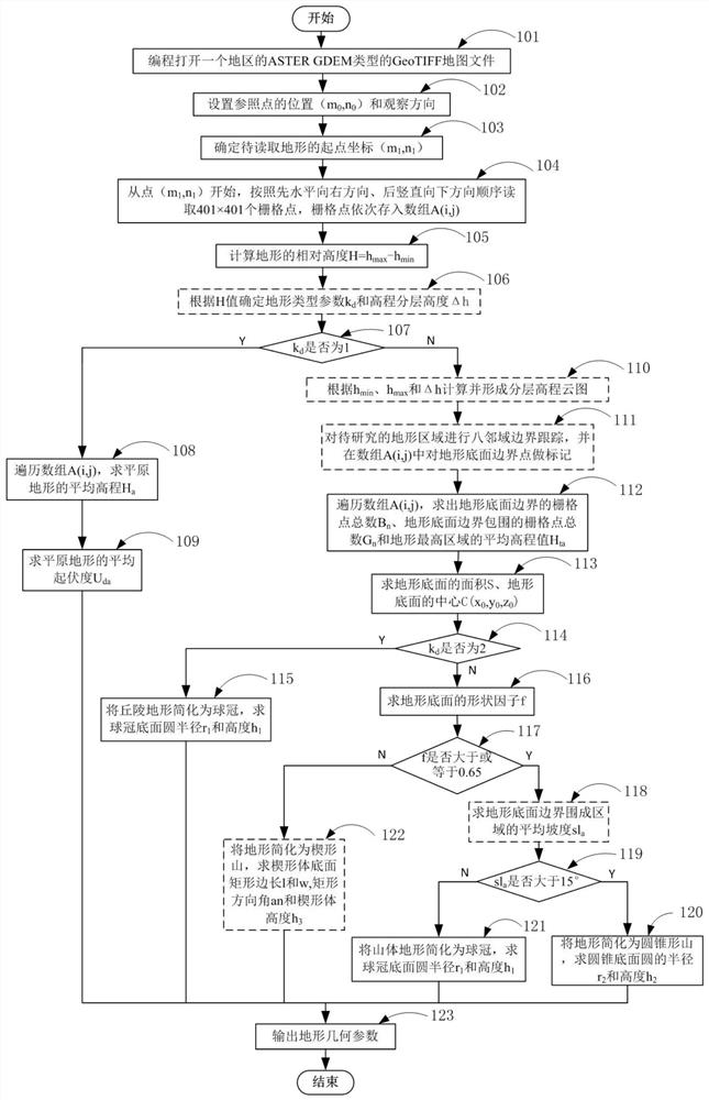
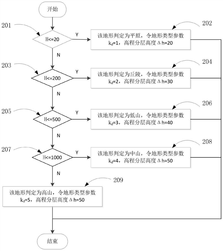
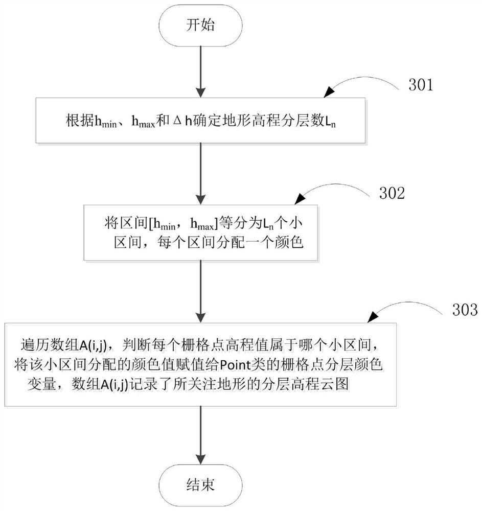
[0157] The invention is used to extract the geometric parameters of the topography of a certain mountain in China. Figure 7 is the actual shape of the mountain that reads the mountain's DEM data and displays it in grid form. Programmatically read the 401×401 grid in the digital map file of ASTER GDEM type GeoTIFF format where the mountain is located, first calculate the relative height to determine that the terrain is an alpine type; then layer and color map its elevation to get Figure 8 The layered elevation cloud image shown; then use the eight-neighborhood boundary tracking algorithm in image processing to obtain the terrain bottom boundary, bottom area and bottom center, and then identify the color representing the maximum elevation interval to obtain the average of the highest terrain area Elevation; finally, the mountain is determined to be a wedge-shaped mountain through the calculation of the shape factor of the bottom surface, and the rectangular side length and dir...


PUM


Abstract

The invention relates to a method for extracting terrain geometric parameters based on layered elevation cloud images, including terrain classification and identification, terrain simplification, and terrain geometric parameter extraction processes. For a 401×401DEM grid terrain specified in a digital map in GeoTIFF format of ASTER GDEM type, through programming, first calculate the relative height and divide the terrain into five types: plain, hill, low mountain, middle mountain, and high mountain; layering and color mapping to obtain the layered elevation cloud image of the specified terrain; then use the eight-neighborhood boundary tracking algorithm in image processing to obtain the bottom surface boundary, bottom surface area and center of the bottom surface of the terrain, and then identify the color representing the maximum elevation interval to Calculate the average elevation of the highest area of ​​the terrain; finally combine the terrain classification, base shape factor calculation, and slope calculation to calculate the geometric parameters of the terrain simplified geometric model plain, spherical cap, cone, and wedge. The invention has the advantages of simple method, small amount of calculation, good real-time performance and practicality.

Description

technical field [0001] The invention belongs to the fields of geographic information system (GIS) and computer graphics and images, and relates to a classification method of topography and geomorphology and a method for extracting topographic geometric parameters and a simplified model, specifically a method for extracting topographic geometric parameters based on layered elevation cloud images , which can be used for automatic discrimination of terrain types, approximate calculation of radio wave propagation and rapid real-time display of terrain models. Background technique [0002] The digital map based on geographic information system (GIS) is supported by geographic information system and digital mapping system, and its functions and functions are constantly improving with the development of GIS technology and digital mapping system. The specific meaning of a digital map refers to a generalized and ordered collection of cartographic elements and discrete data on a reada...

Claims


Application Information

Patent Timeline
Patent Type & Authority Patents(China)
IPC IPC(8): G06T17/05
CPCG06T17/05
Inventor 许社教杜美玲张静明炫龙杨西惠邱扬田锦朱言午
Owner XIDIAN UNIV
Why Eureka
Try Eureka