Permafrost-disaster-information extracting method and device based on satellite remote sensing images

A technology for satellite remote sensing image and information extraction, applied in the field of remote sensing processing, can solve problems such as analysis and processing of permafrost disasters in areas without permafrost, and achieve the effect of protecting the ecological environment along the project.

Active Publication Date: 2017-05-17
NORTHWEST INST OF ECO ENVIRONMENT & RESOURCES CAS
View PDF4 Cites 13 Cited by
  • Summary
  • Abstract
  • Description
  • Claims
  • Application Information

AI Technical Summary

Problems solved by technology

In the prior art, there is no systematic method for analyzing and processing the geomorphology and permafrost disasters in permafrost regions

Method used


Image

  • Permafrost-disaster-information extracting method and device based on satellite remote sensing images
  • Permafrost-disaster-information extracting method and device based on satellite remote sensing images
  • Permafrost-disaster-information extracting method and device based on satellite remote sensing images

Examples


Embodiment Construction

[0056] The following will clearly and completely describe the technical solutions in the embodiments of the present invention with reference to the accompanying drawings in the embodiments of the present invention. Obviously, the described embodiments are only some, not all, embodiments of the present invention. The components of the embodiments of the invention generally described and illustrated in the figures herein may be arranged and designed in a variety of different configurations. Accordingly, the following detailed description of the embodiments of the invention provided in the accompanying drawings is not intended to limit the scope of the claimed invention, but merely represents selected embodiments of the invention. Based on the embodiments of the present invention, all other embodiments obtained by those skilled in the art without making creative efforts belong to the protection scope of the present invention.

[0057] It should be noted that like numerals and let...


PUM


Abstract

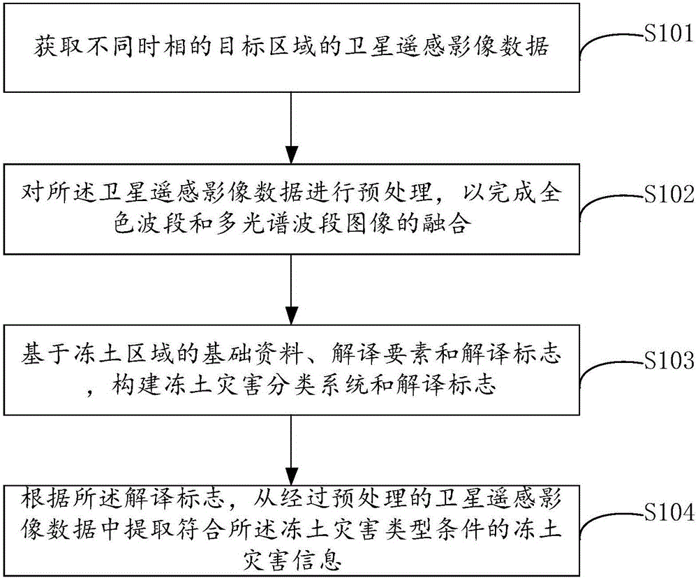
The invention provides a permafrost-disaster-information extracting method and device based on satellite remote sensing images. Satellite remote sensing image data is used in cooperation with the permafrost-disaster-type conditions based on permafrost areas, the automatic classification or human-computer interaction interpretation or wave band synthesis method of a computer is adopted, and the information meeting the permafrost-disaster-type conditions can be extracted out of the satellite remote sensing image data; in this way, permafrost-disaster information databases of relative areas can be established, potential menaces of the poor geological phenomenon to other engineering such as a road and accordingly-and-possibly-caused engineering disease are analyzed, scientific instruction is provided for reducing the occurrence rate of the engineering disease and damage of natural disaster to engineering, a scientific basis is provided for designing and construction of new great permafrost engineering in future areas, and meanwhile the ecological environment along the line is protected.

Description

technical field [0001] The invention relates to the technical field of remote sensing processing, in particular to a method and device for extracting permafrost disaster information based on satellite remote sensing images. Background technique [0002] Permafrost refers to various rocks and soils below zero degrees Celsius and containing ice. Generally, it can be divided into short-term frozen soil (several hours / days to half a month), seasonal frozen soil (half a month to several months) and permafrost (also known as permafrost, which refers to the frozen soil that lasts for two years or more. unmelted soil). The area of ​​permafrost, seasonally frozen soil and short-term frozen soil areas on the earth accounts for about 50% of the land area, of which the permafrost area accounts for 25% of the land area. Permafrost is a soil medium that is extremely sensitive to temperature and contains abundant underground ice. Therefore, permafrost has rheological properties, and its...

Claims


Application Information

Patent Timeline
Patent Type & Authority Applications(China)
IPC IPC(8): G06T7/00G06K9/00G06K9/32
CPCG06T7/0004G06T2207/10032G06T2207/20221G06T2207/30184G06V20/13G06V10/24
Inventor 祁元王建华王宏伟张金龙贾永娟
Owner NORTHWEST INST OF ECO ENVIRONMENT & RESOURCES CAS
Why Eureka
Try Eureka