Supercharge Your Innovation With Domain-Expert AI Agents!

RTK/SINS-based high dynamic positioning attitude-determining system and method

A positioning and attitude determination system, high dynamic technology, applied in the field of navigation, can solve the problems of huge Doppler frequency shift, difficulty in maintaining normal data link communication, difficulty in taking into account high precision and high dynamics, etc., to improve tracking accuracy and positioning Attitude accuracy and the effect of reducing tracking error

Active Publication Date: 2017-05-24
LEADOR SPATIAL INFORMATION TECH CORP
View PDF9 Cites 7 Cited by
  • Summary
  • Abstract
  • Description
  • Claims
  • Application Information

AI Technical Summary

Problems solved by technology

However, in a highly dynamic environment, the RTK communication data link usually has a huge Doppler frequency shift, which makes it difficult to maintain the normal communication of the data link. Therefore, the existing technology is usually difficult to meet the needs of high precision and high dynamics

Method used


Image

  • RTK/SINS-based high dynamic positioning attitude-determining system and method
  • RTK/SINS-based high dynamic positioning attitude-determining system and method
  • RTK/SINS-based high dynamic positioning attitude-determining system and method

Examples


Embodiment Construction

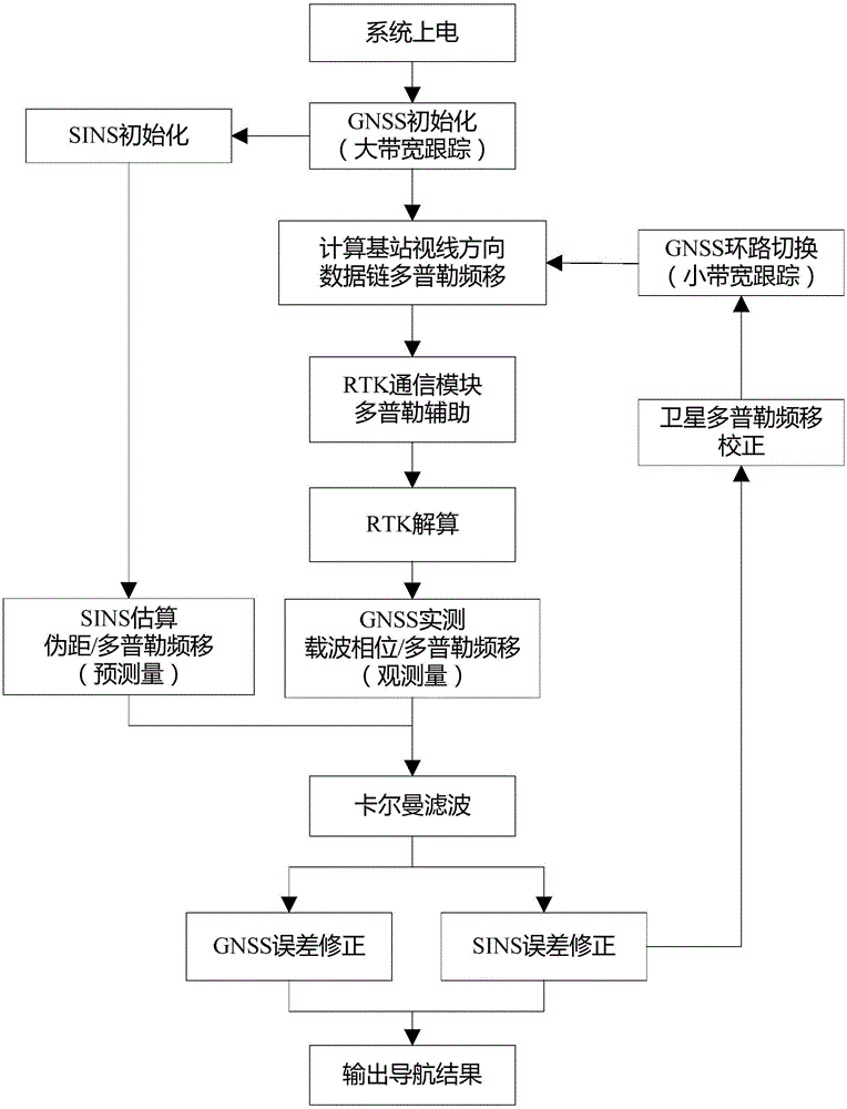
[0059] The technical solution of the present invention will be specifically described below in conjunction with the accompanying drawings and embodiments.

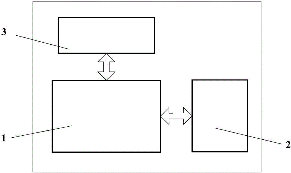
[0060] The present invention proposes a high dynamic positioning and attitude determination system based on RTK / SINS, its structure is as follows figure 1 As shown, it mainly includes: GNSS module 1, SINS module 2 and RTK communication module 3. A communication connection is established between the GNSS module and the SINS module, and a communication connection is established between the GNSS module and the RTK communication module. Among them, the GNSS module performs satellite navigation calculation, and provides initialization data and satellite ephemeris data to the SINS module, and provides data link Doppler assistance to the RKT communication module; the SINS module performs inertial navigation calculation, and provides the tracking loop of the GNSS module Provide Doppler assistance; RTK communication module perform...


PUM


Abstract

The invention discloses an RTK / SINS-based high dynamic positioning attitude-determining system and method. A GNSS module, an SINS module and an RTK communication module are arranged. The method comprises the following steps: after the system is powered on and started, initializing the GNSS module and utilizing the GNSS module to assist the SINS module in completing initializing; calculating a data chain along a sight direction of a base station by the GNSS module, transmitting a Doppler frequency shift, feeding into the RTK communication module and assisting in tracking; receiving differential data broadcast by the base station and transmitting to the GNSS module by the RTK communication module; acquiring the observed volume of Kalman filtering by the GNSS module, and acquiring the forecast volume of Kalman filtering by the SINS module; performing Kalman filtering on the forecast volume of SINS and the observed volume of GNSS, and outputting an integrated navigation result; and calculating a new corrected carrier Doppler frequency shift, feeding into a GNSS tracking loop and assisting, and continuously iterating till the ending of the navigation.

Description

technical field [0001] The invention relates to the field of navigation, in particular to a high-precision positioning and attitude-fixing navigation system and method suitable for high-dynamic scenes. Background technique [0002] Navigation technology has been valued by various countries for many years and has developed rapidly, and has achieved certain results. However, navigation under high dynamic accelerations of 20g to 100g has always been a major problem. In addition to the specific market value in the civilian field, in modern warfare, technological confrontation has become the key. High dynamic carriers such as missiles and fighter jets have put forward new requirements for the reliability and anti-interference ability of modern navigation technology. [0003] For carriers in high dynamic conditions, how to better solve their navigation and positioning has always been a major problem, and has been concerned by many experts and scholars because of its important role...

Claims


Application Information

Patent Timeline
IPC IPC(8): G01S19/49G01C21/16
CPCG01C21/165G01S19/49
Inventor 李德仁邵慧超洪勇张鹏
Owner LEADOR SPATIAL INFORMATION TECH CORP
Features
  • R&D
  • Intellectual Property
  • Life Sciences
  • Materials
  • Tech Scout
  • Unparalleled Data Quality
  • Higher Quality Content
  • 60% Fewer Hallucinations
Learn More