Method and system for electronically acquiring geological survey adit joint data

A technology of geological survey and acquisition method, applied in the field of geological survey, can solve problems such as joint geometric information and physical property information, affect work efficiency, waste human resources, etc. the effect of

Inactive Publication Date: 2017-05-31
加华地学(武汉)数字技术有限公司
View PDF4 Cites 7 Cited by
  • Summary
  • Abstract
  • Description
  • Claims
  • Application Information

AI Technical Summary

Problems solved by technology

The above-mentioned traditional cataloging method needs to transcribe the hand-painted joints into a CAD standard drawing in the post-processing, the operation process is cumbersome, the repetitive workload is heavy, and the efficiency i...

Method used


Image

  • Method and system for electronically acquiring geological survey adit joint data
  • Method and system for electronically acquiring geological survey adit joint data
  • Method and system for electronically acquiring geological survey adit joint data

Examples


Embodiment 1

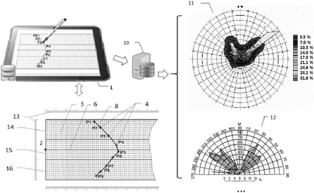
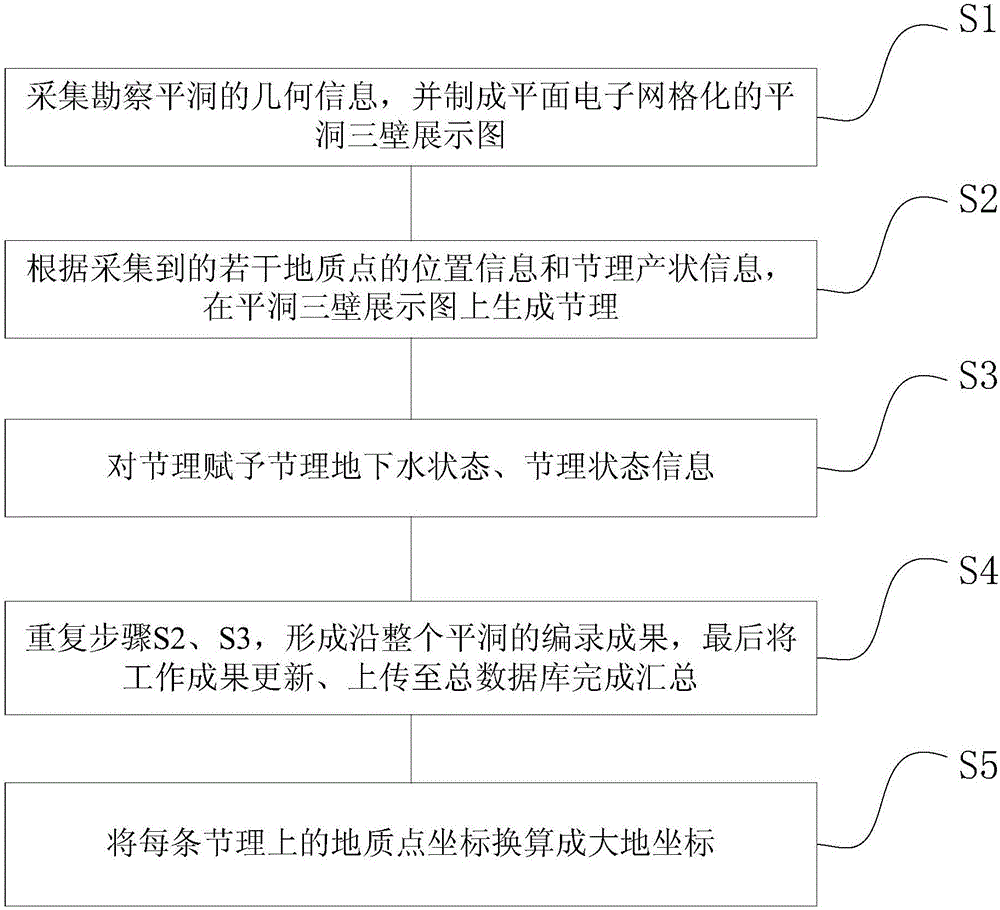
[0031] Figure 1 to Figure 4 A method for electronically collecting joint data in a geological survey flat hole is shown, including the following steps:

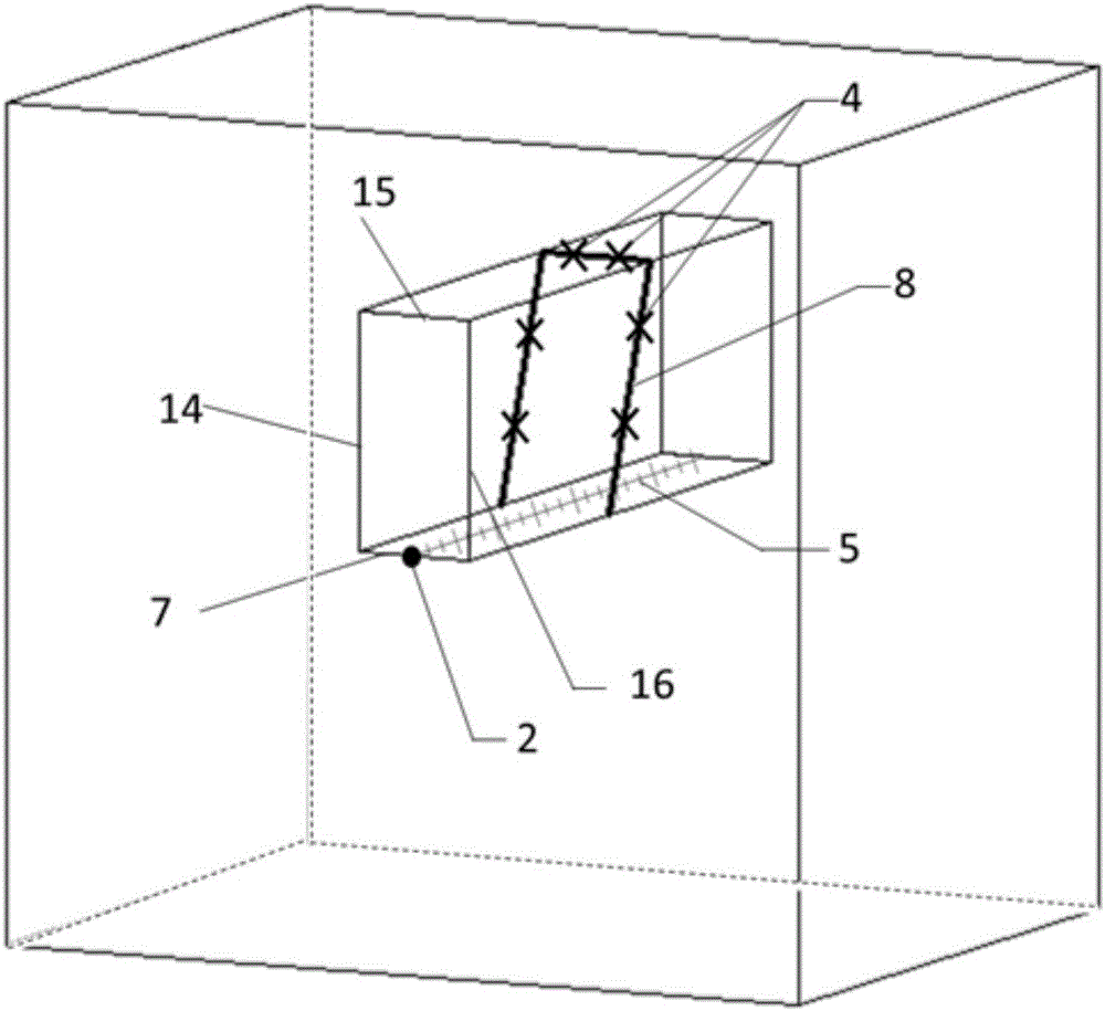
[0032] S1. Collect the geometric information of the reconnaissance flat cave, and make a plane electronic gridded flat cave three-wall display map, and the density of the plane electronic grid can be adjusted according to the density of the collection points; in this embodiment, the scope of flat cave joint cataloging It is the joints on the three surfaces from the entrance to the bottom of the hole, the left side wall 14 of the flat hole, the roof 15 of the flat hole, and the right side wall 16 of the flat hole;

[0033] Before the joint cataloging, set the initial stake number 2 at the entrance of the flat hole bottom plate 7, and use the tape measure 5 for measuring the hole depth to mark the stake number information from the hole mouth to the bottom of the hole. The stake number value of any geological point 4 is from th...

Embodiment 2

[0049] Figure 4 Shown is a kind of electronic acquisition system of joint data in flat tunnels for geological survey, using the method in Embodiment 1, including a display module, a data catalog and processing module, and a database module;

[0050] The display module is used to collect the geometric information of the surveyed flat cavern, and make a planar electronic gridded three-wall display map of the flat cavern and display it graphically; in addition, the display module also assists in the positioning of geological points, the display of catalog results, and the picking and editing Wait;

[0051] The data cataloging and processing module is used for electronically positioning, cataloging and generating joints on the above-mentioned joint information on the three-wall display map of Pingdong according to the collected position information and joint occurrence information of several geological points, and Endow groundwater status and joint status information;

[0052] Th...


PUM


Abstract

The invention relates to a method and a system for electronically acquiring geological survey adit joint data. The method includes steps of S1, acquiring geometric information of survey adits and drawing planar electronic grid adit three-wall display graphs; S2, selecting a plurality of geological points from adit joints, measuring location information and joint attitude information of the various geological points, generating geological points with attributes on electronic grids and sequentially connecting the geological points with one another to form joints; S3, determining joint groundwater states and joint state information according to site conditions and attaching the joint groundwater states and the joint state information to the corresponding joints; S4, repeatedly carrying out the steps S2 and S3, forming catalog results of the integral adits, updating work results and uploading the work results to general databases to summarize the work results. The method and the system have the advantages that the method and the system are beneficial to improving the efficiency of geological catalog work, and adit data acquisition processes can be electronized and standardized.

Description

technical field [0001] The invention relates to the field of geological survey, and more specifically, relates to a method and system for electronically collecting joint data of flat tunnels in geological survey. Background technique [0002] Pingdong catalog is a widely used geological prospecting method. Objects cataloged in flat tunnels generally include: formations, joints, structural surfaces with thickness, weathering and unloading, and fractures. At present, the traditional manual sketch geological cataloging method is generally used for joint cataloging. In this method, the joints to be cataloged are manually drawn on grid paper, and the joint status is manually recorded separately. The above-mentioned traditional cataloging method needs to transcribe the hand-painted joints into a CAD standard drawing in the post-processing, the operation process is cumbersome, the repetitive workload is heavy, and the efficiency is low, which leads to the waste of human resources....

Claims


Application Information

Patent Timeline
IPC IPC(8): G01V9/00
CPCG01V9/00
Inventor 李浩马凯李振郭福钟朱焕春朱永生张云涛余超朱洁李梦吴兴文
Owner 加华地学(武汉)数字技术有限公司
Why Eureka
Try Eureka