

A Spatial Analysis Method for Evaluating the Steady State of Slope During Excavation
A technology of spatial analysis and stable state, applied in geometric CAD, special data processing applications, etc., can solve the problems of macroscopic judgment, inapplicability, lack of monitoring indicators, etc., to achieve the effect of spatial analysis
- Summary
- Abstract
- Description
- Claims
- Application Information
AI Technical Summary
Problems solved by technology
Method used
Image


Examples
Embodiment Construction
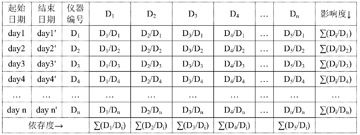
[0029] Before further describing the present invention according to specific embodiments, the spatial influence matrix and the cross influence matrix involved in the present invention will be described in detail first. See Table 1 for the spatial impact matrix and Table 2 for the cross impact matrix.
[0030] Table 1 Space Impact Matrix
[0031]
[0032] Assume that there are n independent displacement monitoring points D in a certain project scope 1 、D 2 ,...,D k ,...,D n ,D i As the monitoring point, according to the general law of the project site, it is assumed that a certain measuring point (D k ) for an initial period of time after the installation, the excavation work will be carried out at the newly installed measuring point (D k )nearby. With the impact of excavation operations, D k There will be a significant increase in displacement, and at the same time, other measuring points will also increase or decrease in displacement during the corresponding period...
PUM
 Abstract
Description
Claims
Application Information