Method for identifying airport target in remote sensing image by fusing scene information and depth features

A technology of remote sensing images and depth features, applied in character and pattern recognition, neural learning methods, computer components, etc., can solve problems such as neglect, over-segmentation, and low significance, so as to improve detection accuracy and optimize classification effects , the effect of improving the distinguishability

Active Publication Date: 2017-05-31
WUHAN UNIV
View PDF8 Cites 42 Cited by
  • Summary
  • Abstract
  • Description
  • Claims
  • Application Information

AI Technical Summary

Problems solved by technology

The grayscale-based method is limited by the grayscale distribution and illumination conditions of the image, and it is easy to cause problems such as over-segmentation and low significance, while the method based on the airport struct

Method used


Image

  • Method for identifying airport target in remote sensing image by fusing scene information and depth features
  • Method for identifying airport target in remote sensing image by fusing scene information and depth features
  • Method for identifying airport target in remote sensing image by fusing scene information and depth features

Examples


Embodiment Construction

[0024] In order to better understand the technical solution of the present invention, the present invention will be further described in detail below in conjunction with the accompanying drawings and embodiments.

[0025] With the further development of neural networks, especially deep convolutional neural networks, their strong feature self-learning ability and detection effect gradually emerge. The convolutional neural network combines feature extraction and classification, and has been widely used in many fields such as speech recognition, image processing, and natural language processing. To make a judgment, the airport target can be accurately identified from the remote sensing image after the frame regression algorithm is carried out.

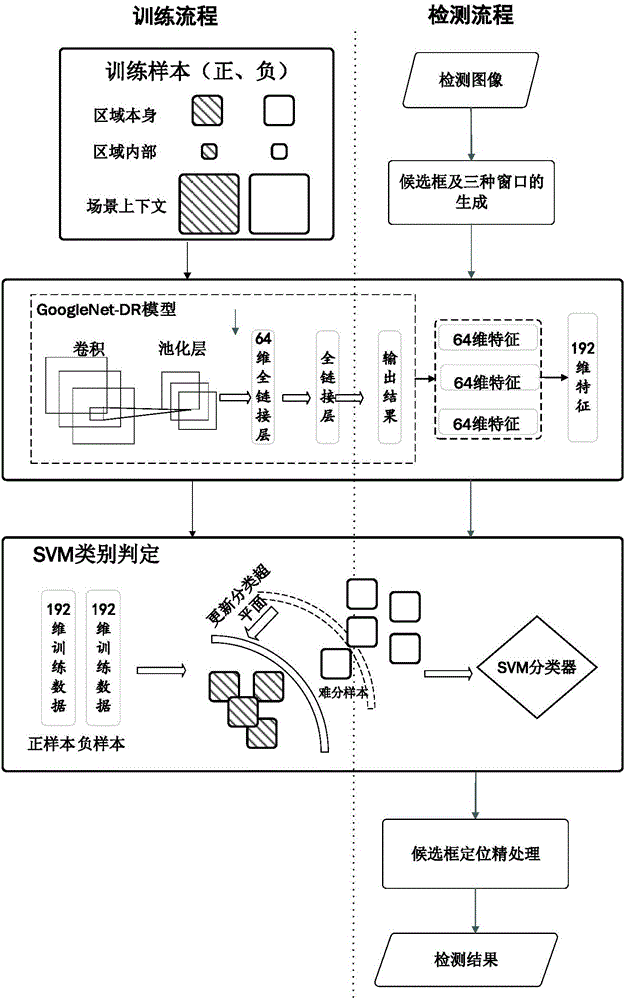
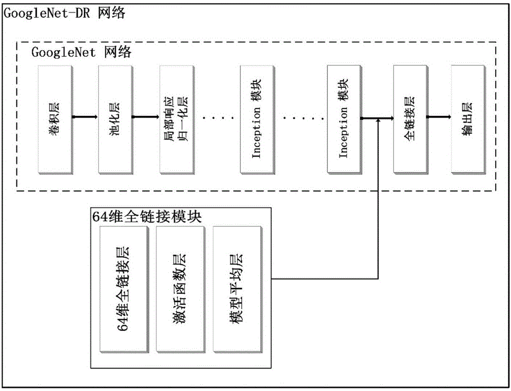
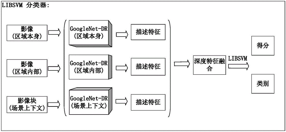
[0026] Based on the feature self-learning ability of the deep convolutional neural network, the present invention provides an automatic recognition method for remote sensing image airport targets based on scene context and deep fusion fea...


PUM


Abstract

The invention provides a method for identifying an airport target in a remote sensing image by fusing scene information and depth features. The method comprises the steps of generating target candidate boxes of the airport on the image in a sliding window manner according to a plurality of preset sizes; constructing a deep convolutional neural network feature extractor, adding corresponding internal window and context window for each target candidate box for realizing learning and extraction of features, internal features and context features of regional images of the candidate boxes, and performing combination to obtain a fused description feature; performing type determination of the target candidate boxes based on a support vector machine (SVM) to obtain type attributes of the target candidate boxes and probabilities of belonging to corresponding types; and performing locating precision processing of the target candidate boxes to obtain an identification result of the airport target in the remote sensing image. By applying the method, the position and size of the airport can be quickly and accurately identified in the high-resolution remote sensing image; and the method is suitable for research on identification of the airport in the remote sensing image in various illumination conditions and various complex backgrounds.

Description

technical field [0001] The invention belongs to the technical field of automatic target identification, in particular to an automatic identification method for airport targets in complex remote sensing images. Background technique [0002] As an important means of transportation and military facilities, airports play a very important role in various fields, especially basic information, aviation security, and national defense construction. Therefore, it is very important to quickly and accurately identify and locate airports from massive remote sensing images. significance. Traditional remote sensing image target detection methods are generally divided into three steps: one is region search, the other is feature extraction, and the third is classifier judgment. There are two main types of methods. One is based on the gray feature of the image, and determines the suspected area of ​​the airport through image segmentation or visual saliency mechanism. The final judgment resu...

Claims


Application Information

Patent Timeline
IPC IPC(8): G06K9/62G06N3/02G06N3/08
CPCG06N3/02G06N3/08G06V2201/07G06F18/21G06F18/2411
Inventor 肖志峰宫一平龙洋
Owner WUHAN UNIV
Why Eureka
Try Eureka