Forest fire fast monitoring positioning system and monitoring positioning method thereof
A positioning system and forest fire technology, which is applied in the field of forest fire rapid monitoring and positioning system, can solve the problems of low intelligence and poor real-time performance, and achieve the effects of small environmental factors, low cost and simple control
- Summary
- Abstract
- Description
- Claims
- Application Information
AI Technical Summary
Problems solved by technology
Method used
Image
Examples
Embodiment 1
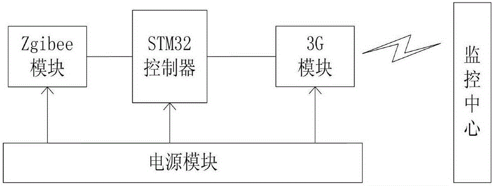
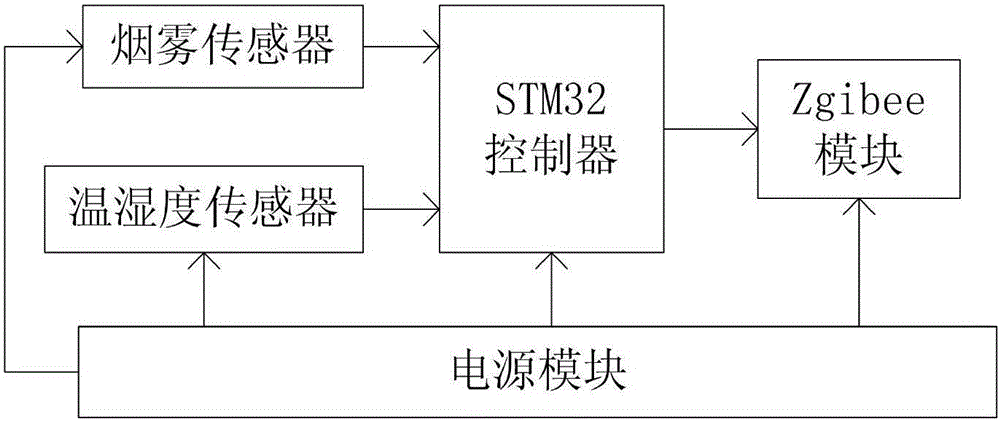
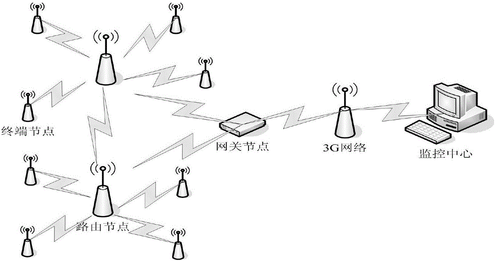
[0018] Embodiment 1: as Figure 1-Figure 6 As shown, a forest fire rapid monitoring and positioning system includes a terminal node and a gateway node. The terminal node and the gateway node are connected through a ZigBee wireless module. The terminal node includes a controller one and a temperature and humidity sensor and a smoke sensor connected to the controller. The gateway node includes a controller 2, and the controller 2 is connected to the monitoring center through a 3G network module.
[0019] Preferably, the above-mentioned controller 1 and controller 2 adopt STM32F103 controller chip, and STM32F103 has 12-bit AD channel.
[0020] Preferably, the above-mentioned ZigBee wireless module adopts CC2530 chip, selects CC2530 chip as the core of ZigBee module, CC2530 chip integrates single-chip microcomputer, ADC, wireless communication module in one, can support the latest Zigbee protocol, has low power consumption, low cost, high reliability sexual advantages. Due to th...
Embodiment 2
[0023] Embodiment 2: a kind of monitoring location method of forest fire rapid monitoring location system, this method is: monitor the temperature and humidity of environment in real time by temperature and humidity sensor and smoke sensor, and temperature and humidity are passed to monitoring in real time by wireless module and 3G network module The center, first of all, monitors the fire situation in the area through the temperature and humidity sensor and the smoke sensor of the terminal node, and transmits the fire situation collection parameters to the routing node, and the routing node is responsible for packaging the parameter information collected by multiple nodes, and It is sent to the gateway node, and then the gateway node sends it to the Internet through the 3G network module, and finally reaches the remote fire monitoring center. The monitoring center calculates the location of the collection node through the centroid positioning algorithm, which is the location of...
PUM
 Abstract
Description
Claims
Application Information
 - R&D
- Intellectual Property
- Life Sciences
- Materials
- Tech Scout
- Unparalleled Data Quality
- Higher Quality Content
- 60% Fewer Hallucinations
Browse by: Latest US Patents, China's latest patents, Technical Efficacy Thesaurus, Application Domain, Technology Topic, Popular Technical Reports.
© 2025 PatSnap. All rights reserved.Legal|Privacy policy|Modern Slavery Act Transparency Statement|Sitemap|About US| Contact US: help@patsnap.com


