Method for evaluating real-time operation levels of wide-range urban public transport line networks on basis of GPS (global positioning system) data of buses

A GPS data, urban bus technology, applied in traffic flow detection, traffic control system, traffic control system of road vehicles, etc., can solve the problem of not being able to respond to real feelings, and achieve the effect of improving accuracy and rapidity

Active Publication Date: 2017-05-31
济南全通信息科技有限公司
View PDF5 Cites 35 Cited by
  • Summary
  • Abstract
  • Description
  • Claims
  • Application Information

AI Technical Summary

Problems solved by technology

In the evaluation of road operation conditions, the congestion index represents the driving state of mixed traffic flow dominated by cars, and can better reflect the congestion feelings of car users. The disadvantage is that it cannot

Method used


Image

  • Method for evaluating real-time operation levels of wide-range urban public transport line networks on basis of GPS (global positioning system) data of buses
  • Method for evaluating real-time operation levels of wide-range urban public transport line networks on basis of GPS (global positioning system) data of buses
  • Method for evaluating real-time operation levels of wide-range urban public transport line networks on basis of GPS (global positioning system) data of buses

Examples


Embodiment Construction

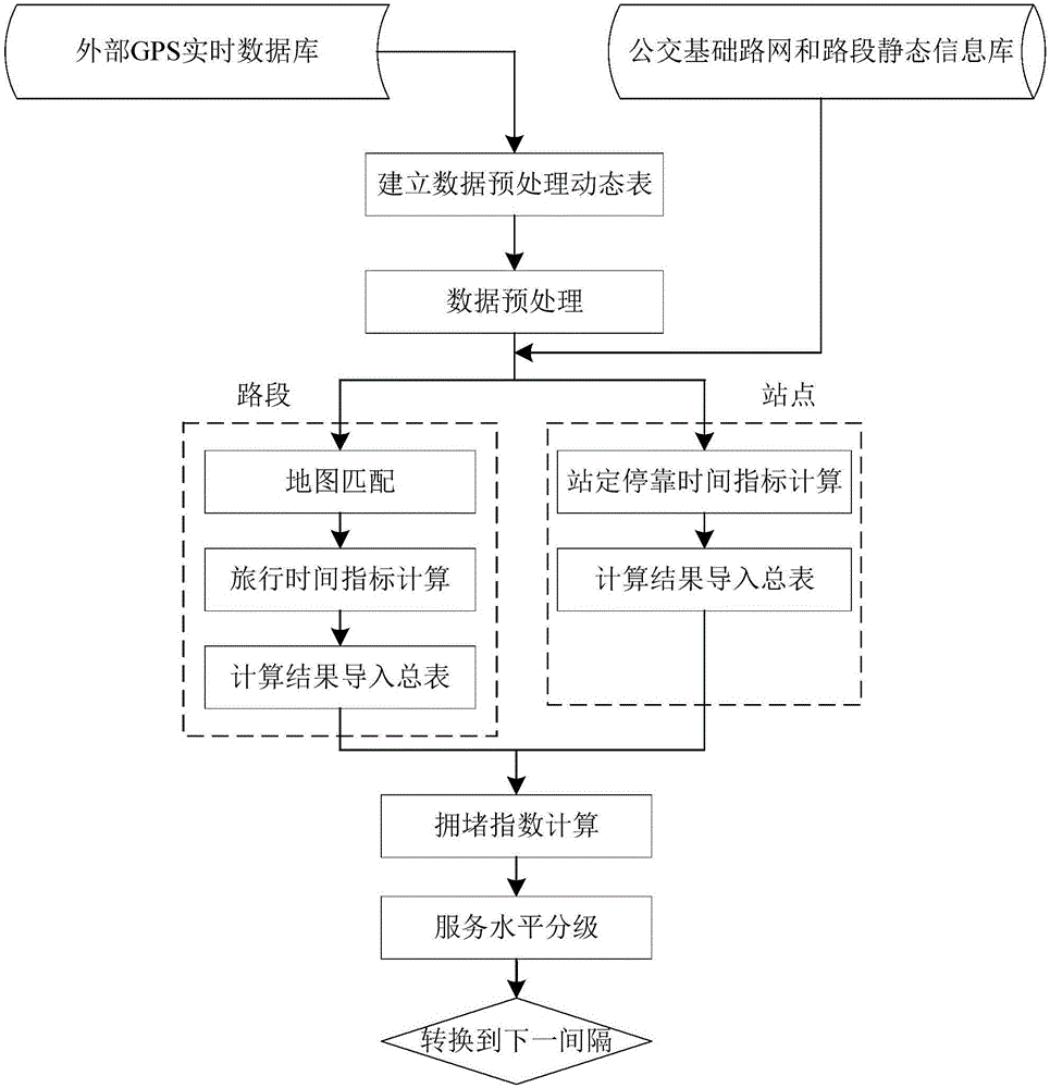
[0016] A method for evaluating the real-time operation level of a large-scale urban bus network based on bus GPS data, including the following steps:

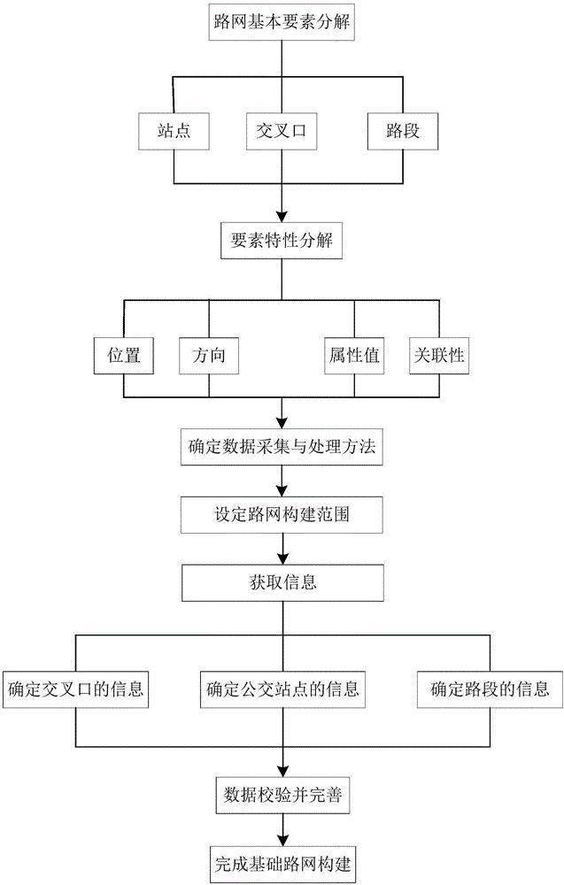
[0017] (1) Establish a standardized static road network basic information database and bus line network basic information database. The establishment of the bus line network basic information database includes: defining road sections, defining sub-road sections, defining road section polylines, determining bus stop information, and determining bus line information , Matching site and section information;

[0018] The road between two adjacent intersections is a road section, and the information of the road section includes the starting number of the intersection, the end number of the intersection, the number of the road section, the name of the road section, the length of the road section, the direction of the road section, the name of the road where the road section is located, and the grade of the road where the road section ...


PUM


Abstract

The invention discloses a method for evaluation real-time operation levels of wide-range urban public transport line networks on the basis of GPS (global positioning system) data of buses. The method includes preprocessing data; matching maps with one another; computing travel time indexes; computing station stopping time indexes; computing congestion indexes. Erroneous, repeated, missing and redundant data of the real-time GPS data are processed at the step for preprocessing the data; spatial-time locations of each single GPS point on the corresponding map are estimated at the step for matching the maps with one another; the travel time indexes are travel time indexes of each single bus on a single secondary road section on the basis of map matching data of the single bus, so that travel time indexes of whole road networks can be obtained; single stopping time of each single bus at each single station is computed according to the duration from the moment when the bus is positioned at the station to the moment when the bus leaves the station, and accordingly the station stopping time indexes of the stations can be solved; the travel time indexes and the station stopping time indexes are combined with one another and are analyzed and processed at the step for computing the congestion indexes, and an index which can represent the degree of crowdedness of the road sections by the aid of bus travel time and bus station stopping time can be ultimately solved.

Description

technical field [0001] The invention relates to a method for evaluating the real-time operation level of a large-scale urban public transport network based on bus GPS data, and belongs to the technical field of intelligent transportation systems. Background technique [0002] In order to solve the traffic congestion problem brought about by the increasing demand for urban traffic, public transport priority has become one of the improvement strategies implemented by urban traffic managers. For urban traffic managers, in order to stimulate more urban residents to travel by public transport, it is necessary to improve the service level of the public transport system as much as possible, which depends on timely grasping the operation status of the public transport network, especially when buses are on the road system. Moderate running time or running speed, which is conducive to the reasonable planning of bus priority measures in a multi-mode network environment. At the same ti...

Claims


Application Information

Patent Timeline
IPC IPC(8): G08G1/01
CPCG08G1/0112G08G1/0133
Inventor 潘述亮邹难卢小林王璇耿会灵
Owner 济南全通信息科技有限公司
Why Eureka
Try Eureka