Parcel area calculating method based on line path

A calculation method, line path technology, applied in the field of plot area calculation based on line path, can solve problems such as the error between the measured area and the actual area, the inability to count the accurate plot area, and the inability to obtain relevant interests of farmers, so as to reduce the error Effect

Inactive Publication Date: 2017-06-13
ZHUZHOU JIACHENG TECH DEV CO LTD
View PDF3 Cites 6 Cited by
  • Summary
  • Abstract
  • Description
  • Claims
  • Application Information

AI Technical Summary

Problems solved by technology

[0002] Agricultural users often need to make statistics on the area of ​​plots as a basis for billing or other statistical considerations; due to the complexity of the terrain of agricultural operations, the area of ​​many plots cannot be calculated accurately, resulting in the inability to obtain the relevant benefits of farmers and government departments. Statistically accurate land area affects decision-making and management
[0003] The existing plot calculation methods are generally estimation method and GPS measurement method, and the traditional estimation method obviously cannot meet the requirements of modern agriculture for accurate acquisition of plot area data; and the GPS measurement method, due to the irregularity of the terrain and the use of When harvesting agricultural machinery obtains GPS measurement points, the track of the harvester is a Z-shaped circular harvest, or a back-shaped circular harvest. This track is different from the measurement method of the conventional acre meter. The GPS points used can easily cause calculation confusion or double calculation, resulting in a large error between the measured area and the actual area

Method used


Image

  • Parcel area calculating method based on line path
  • Parcel area calculating method based on line path
  • Parcel area calculating method based on line path

Examples


Embodiment Construction

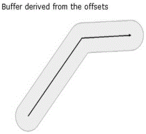
[0022] A method for calculating land area based on line paths. The GPS used is the Maxima GPS terminal. According to the communication protocol, the update time period of GPS point data is 1hz, and the unit of longitude and latitude sent is one millionth of a degree, and the unit is about 0.113m (calculated according to 113km corresponding to one degree at the equator), GPS positioning accuracy is about 3m, considering that the general span of agricultural machinery operation is not too large (<10km), this error can be ignored as a unified system error, or use a unified system The adjustment factor is eliminated.

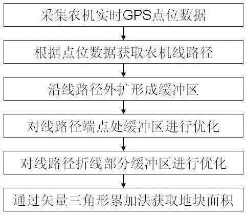
[0023] It mainly includes the following steps:

[0024] 1) Determine the target plot, install the GPS terminal on the agricultural machinery in operation, collect the latitude and longitude data in real time during operation, and the latitude and longitude coordinates are distributed on the plot in the form of row or column GPS point data;

[0025] 2) Arrange the G...


PUM


Abstract

The invention discloses a method for calculating the land area based on a line path. Firstly, the target land is determined, and a GPS terminal is installed on the agricultural machine for operation, and the latitude and longitude data are collected in real time during operation, and the latitude and longitude coordinates are GPS point data in rows or columns The form is distributed on the plot of work; then, arrange the GPS point data in time order to form a continuous or discontinuous line path, based on the line path, expand a certain radius along the two sides of the line path to form The polygon becomes the buffer zone; the sector search method is used to optimize the endpoints of the line path to form a buffer area along the endpoint; the convex arc method is used to optimize the buffer area of ​​the polyline part of the line path to form the final line path polyline Part of the optimized buffer zone; finally, the area of ​​the optimized buffer zone is calculated by the vector triangle accumulation method to obtain the final area of ​​the polyhedral plot.

Description

technical field [0001] The invention belongs to the technical field of intelligent agriculture, and in particular relates to a calculation method for plot area based on a line path. Background technique [0002] Agricultural users often need to count the land area as a basis for billing or other statistical considerations; due to the complexity of the terrain of agricultural operations, the area of ​​many land plots cannot be calculated accurately, resulting in the inability to obtain the relevant interests of farmers and government departments. Statistically accurate land area affects decision-making and management. [0003] The existing plot calculation methods are generally estimation method and GPS measurement method, and the traditional estimation method obviously cannot meet the requirements of modern agriculture for accurate acquisition of plot area data; and the GPS measurement method, due to the irregularity of the terrain and the use of When harvesting agricultura...

Claims


Application Information

Patent Timeline
Patent Type & Authority Applications(China)
IPC IPC(8): G01B7/32
CPCG01B7/32
Inventor 胡辉廖小路毛轩昂周宁赵志军
Owner ZHUZHOU JIACHENG TECH DEV CO LTD
Why Eureka
Try Eureka