Object-based remote sensing image super-resolution charting method

A remote sensing image and super-resolution technology, applied in the field of geospatial information, can solve problems such as increased spectral heterogeneity, complex mixed objects, and reduced spectral differences, to improve classification accuracy and resolution, high precision and quality, Avoiding the Salt and Pepper Effect

Active Publication Date: 2017-06-13
HOHAI UNIV +1
View PDF3 Cites 9 Cited by
  • Summary
  • Abstract
  • Description
  • Claims
  • Application Information

AI Technical Summary

Problems solved by technology

However, due to the constraints of ubiquitous mixed pixels and image segmentation methods (Clinton et al., 2010; Han Peng et al., 2010), the results of image segmentation include both pure objects and "mixed objects", which are different from those based on The mixed pixel problem faced by pixel classification is similar to
In addition, as the spatial resolution of the image increases, the details of the ground objects that can be expressed by the image also increase, which causes the spectral heterogeneity within the same

Method used


Image

  • Object-based remote sensing image super-resolution charting method
  • Object-based remote sensing image super-resolution charting method
  • Object-based remote sensing image super-resolution charting method

Examples


Embodiment Construction

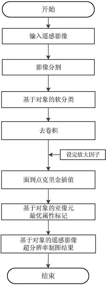
[0032] Below in conjunction with accompanying drawing, technical scheme of the present invention is described in further detail:

[0033] Such as figure 1 Shown, the specific implementation steps of the present invention are as follows:

[0034] Step 1. Preprocess the remote sensing image, obtain multiple objects through image segmentation, and perform object-based soft classification to obtain the soft classification category ratio value of each object, that is, the proportion of each category in each object;

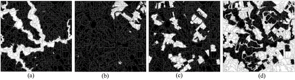
[0035] figure 2 Shown is a 360×360 pixel image after image segmentation, and the proportion map of each object corresponding to different object categories obtained through object-based soft classification. figure 2 is the object-based soft classification result; where, figure 2 In (a) is water body, figure 2 (b) is bare land, figure 2 In (c) is the cultivated land, figure 2 (d) in is grassland.

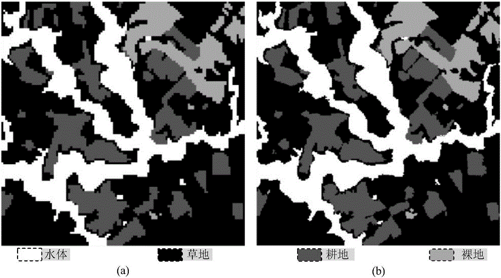
[0036] Step 2. Divide all objects obtained in step 1 into pur...


PUM


Abstract

The invention discloses an object-based remote sensing image super-resolution charting method. Object-based soft classification is carried out by aiming at a mixed object problem with which an object-based remote sensing classification process is faced so as to obtain the category ratio of each object on the basis of the object-based soft classification; and a spatial relationship between the mixed object and a neighborhood object thereof is utilized, on the basis of the first law of geography, i.e., a spatial correlation principle, the spatial correlation feature of each sub pixel in the mixed object is estimated by virtue of a deconvolution and surface to point kriging interpolation technology in statistics, and an object-based linear optimization model is constructed under the ratio constraint of each category of the mixed object to determine the optimal category attribute of the sub-pixel so as to finish the remote sensing image super-resolution charting. The method has the advantages of high practicality, high simulation accuracy and the like and is suitable for ground surface information extraction and geoscience data mining works including remote sensing data classification, land coverage/ utilization, change detection and the like.

Description

technical field [0001] The invention relates to the technical field of geospatial information, in particular to an object-based remote sensing image super-resolution mapping method. Background technique [0002] Extracting land cover / use basic data from remote sensing images through classification technology is a hot field in the research of remote sensing information extraction. However, the mixed pixels that commonly exist in remote sensing images are the main factors that affect the classification results. Super-resolution mapping technology (also known as sub-pixel mapping or sub-pixel positioning) is a new technology for solving mixed pixel classification (Atkinson, 1997), which is a soft classification of low spatial resolution images (also known as Mixed pixel decomposition) is downscaled to a multi-level higher spatial resolution hard classification map (Ge et al., 2016; Ling et al., 2014; Zhong and Zhang, 2012), that is, sub Marker map of ground object categories ...

Claims


Application Information

Patent Timeline
IPC IPC(8): G06T3/40
CPCG06T3/4053
Inventor 陈跃红葛咏贾远信安如
Owner HOHAI UNIV
Why Eureka
Try Eureka