
Method for gathering ships by calculating frames, half widths and heights with three-dimensional coordinates
A three-dimensional coordinate and rib position technology, applied in the field of shipbuilding, can solve the problems of large error accumulation, low precision and labor, and achieve the effects of small error accumulation, high precision and significant economic benefits.
- Summary
- Abstract
- Description
- Claims
- Application Information
AI Technical Summary
Problems solved by technology
Method used
Image

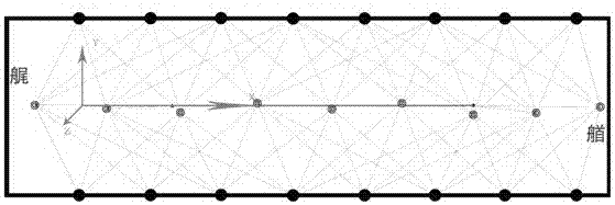


Examples
Embodiment Construction
[0026] A method for closing a ship by calculating rib positions, half-widths and heights using three-dimensional coordinates, comprising the following steps:
[0027] (1) Coordinate system establishment:
[0028] Establish the coordinate system of the stern axis of the ship according to the dock / sway, such as figure 1 shown.
[0029] A pair of control points are arranged every 30m on both sides of the dock / sway, and a certified total station (angle measurement accuracy ±0.5″, distance measurement accuracy ±0.6mm+1ppm) is used for field observation, and the measurement data is connected to the total station via Bluetooth. It is automatically recorded in the dock / sway stern axis coordinate system establishment software, and the observations are made according to the following technical indicators:
[0030] Ø The total station should have the functions of automatic collimation, automatic observation and automatic recording, and its nominal accuracy should meet: the direction m...
PUM
 Abstract
Description
Claims
Application Information