Real-time three-dimensional geographical mapping system for unmanned aerial vehicle

A real-time three-dimensional, unmanned aerial vehicle technology, applied in surveying and navigation, surveying devices, photogrammetry/video surveying, etc., can solve the problems of many uncertain factors, poor acquisition accuracy, and high weather conditions.

Inactive Publication Date: 2017-07-07
苏州光之翼智能科技有限公司
View PDF6 Cites 12 Cited by
  • Summary
  • Abstract
  • Description
  • Claims
  • Application Information

AI Technical Summary

Problems solved by technology

The existing three-dimensional geographic information rendering requires professional personnel with low-altitude flight qualifications, aircraft on duty, and data collection through complex recording and camera equipment
[0003] The whole process has high requirements on personnel and weather conditions; and due to more human-computer interaction, there are many uncertain factors, poor acquisition accuracy and poor real-time performance
[0004] Furthermore, this kind of drawing method often needs to collect first and then process it. For some specific scenarios and emergencies that require real-time construction of the system, it cannot meet the application requirements

Method used


Image

  • Real-time three-dimensional geographical mapping system for unmanned aerial vehicle
  • Real-time three-dimensional geographical mapping system for unmanned aerial vehicle
  • Real-time three-dimensional geographical mapping system for unmanned aerial vehicle

Examples


Embodiment Construction

[0021] The present invention will be described in detail below with reference to the accompanying drawings and in combination with embodiments.

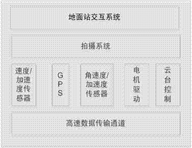
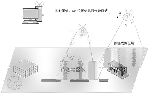
[0022] refer to figure 1 As shown, a real-time three-dimensional geographic surveying and mapping system for unmanned aerial vehicles includes a ground station interactive system, a shooting system, a speed / acceleration sensor, GPS, an angular velocity / acceleration sensor, a motor drive, a cloud platform control and a high-speed data transmission channel, and the ground The station interaction system communicates with the ground station through a wireless network, and data is transmitted between the ground station and the UAV through the high-speed data transmission channel.

[0023] Velocity and acceleration sensor: detect the current three-dimensional velocity and acceleration information to complete attitude analysis

[0024] Angular velocity and acceleration sensor: detect the current three-dimensional angular velocity and accel...


PUM


Abstract

The invention discloses a real-time three-dimensional geographical mapping system for an unmanned aerial vehicle. The system comprises a ground station interaction system, a photographing system, a velocity/acceleration sensor, a GPS, an angular velocity/acceleration sensor, motor driving, cloud deck control and a high-speed data transmission channel. The ground station interaction system communicates with a ground station through a wireless network, and data are transmitted through the high speed data transmission channel between the ground station and the unmanned aerial vehicle. By route planning on a to-be-tested region, image and position information is collected automatically in real time; and furthermore, the ground station can operate and construct a three-dimensional geographical information map in real time through a real-time transmission system.

Description

technical field [0001] The invention relates to a real-time three-dimensional geographic surveying and mapping system for an unmanned aerial vehicle. Background technique [0002] With the needs of digital city construction, security, and forest fire prevention, it is necessary to construct a three-dimensional geographic information map through aerial photography. Due to the advantages of lightness and flexibility, strong programming ability, and low environmental requirements, drones can take off at any time when needed. The existing three-dimensional geographic information rendering requires professional personnel with low-altitude flight qualifications, aircraft on duty, and data collection through complex recording and camera equipment. [0003] The whole process has high requirements on personnel and weather conditions; moreover, due to more human-computer interaction, there are many uncertain factors, the acquisition accuracy is poor, and the real-time performance is ...

Claims


Application Information

Patent Timeline
Patent Type & Authority Applications(China)
IPC IPC(8): G01C11/00G01C11/08
CPCG01C11/00G01C11/08
Inventor 丁军冯翼王猛
Owner 苏州光之翼智能科技有限公司
Why Eureka
Try Eureka