Intelligent road line drawing system based on unmanned aerial vehicle cooperation and method thereof

A technology of intelligent roads and drones, applied in the field of drones, can solve the problems of low spraying efficiency, waste of human and material resources, etc.

Active Publication Date: 2017-07-25
广州云舟智慧城市勘测设计有限公司
View PDF7 Cites 15 Cited by
  • Summary
  • Abstract
  • Description
  • Claims
  • Application Information

AI Technical Summary

Problems solved by technology

[0004] The above two methods all have a waste of manpower and material resources, and the spraying efficiency is not high

Method used


Image

  • Intelligent road line drawing system based on unmanned aerial vehicle cooperation and method thereof
  • Intelligent road line drawing system based on unmanned aerial vehicle cooperation and method thereof
  • Intelligent road line drawing system based on unmanned aerial vehicle cooperation and method thereof

Examples


Embodiment 1

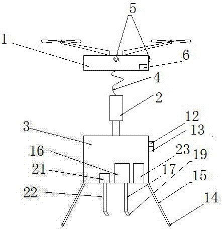
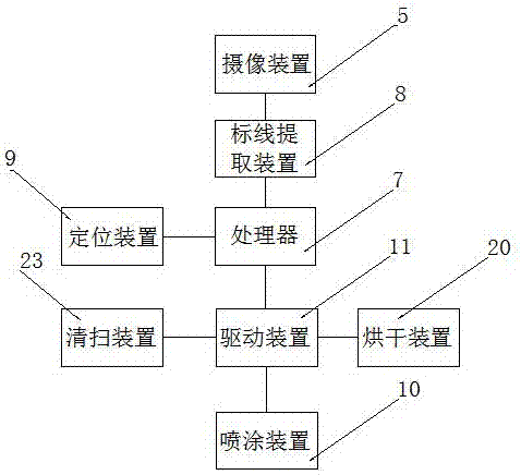
[0030] Such as figure 1 , image 3 As shown, an intelligent road line supplement system based on UAV cooperation includes a UAV 1, a connecting device 2, and a marking mechanism 3. The UAV 1 and the connecting device 2 are connected by an iron chain 4, The unmanned aerial vehicle 1 is provided with a camera 5 and a navigation device 6, and the marking mechanism 3 includes a processor 7, a marking extraction device 8, a positioning device 9, a spraying device 10, a driving device 11, and the processor 7 Connect with drone 1, navigation device 6, marking extraction device 8, positioning device 9, driving device 11, described camera device 5 is connected with marking extraction device 8, and described driving device 11 is connected with spraying device 10, drives The device 11 is used to drive the spraying device 10 to draw a line. The front of the marking mechanism 3 is provided with a laser rangefinder 12 and a radar speedometer 13. The laser rangefinder 12 and the radar speed...

Embodiment 2

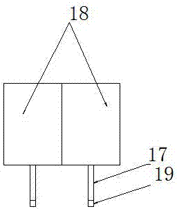
[0034] Such as figure 2 , image 3 As shown, the scribing mechanism 3 also includes a drying device 20, and the drying device 20 includes a dryer 21 and a drying spray pipe 22, and the dryer 21 is connected to the driving device 11, and the spraying device 10 After spraying, the driving device 11 drives the drying device 20 to dry the paint. The marking mechanism 3 also includes a cleaning device 23, which is a pop-up structure, and the cleaning device 23 is connected with the driving device 11 for cleaning the road surface. The processor 7 analyzes whether the road surface where the marking line is located is suitable for spraying according to the image of the received marking line. If it is analyzed that there is rubbish on the road surface, it outputs a cleaning signal to the driving device 11, and the driving device 11 drives the cleaning device 23 to pop up to clean the road surface. If there is accumulated water on the road surface, a drying signal is output to the dr...

Embodiment 3

[0039] Such as Figure 4 As shown, a laser rangefinder 12 and a radar speedometer 13 are arranged in front of the marking mechanism 3, and the laser rangefinder 12 and the radar speedometer 13 are connected to the processor 7, and the laser rangefinder 12 For detecting the distance between the obstacle ahead and the marking mechanism 3, the radar speedometer 13 is used for detecting the speed of the obstacle ahead, if the processor 7 judges that there is an obstacle coming in the received aerial picture, according to the laser The distance value transmitted from the rangefinder 12 and the speed value transmitted from the radar speedometer 13 calculate the time required for the obstacle in front to reach the position of the line replenishment mechanism, and set a preset safe time interval. When the calculated by the processor 7 When the time is within the safe time interval, a take-off signal is sent to the UAV 1, and a cover signal is output to the drive device 11 at the same ...


PUM


Abstract

The invention discloses an intelligent road line supplementation system based on unmanned aerial vehicle cooperation and a method thereof. The intelligent road line supplementation system comprises an unmanned aerial vehicle, a connecting device and a line drawing mechanism. The unmanned aerial vehicle is connected with the connecting device through an iron chain and provided with a camera device and a navigation device. The line drawing mechanism comprises a processor, a sign line extraction device, a positioning device, a spraying device and a drive device. The processor is connected with the unmanned aerial vehicle, the navigation device, the sign line extraction device, the positioning device and the drive device. The camera device is connected with the sign line extraction device. The drive device is connected with the spraying device and used for driving the spraying device for line drawing. A laser range finder and a radar speed detector are arranged in front of the line drawing mechanism and connected with the processor. The laser range finer is used for detecting the distance between a front obstacle and the line drawing mechanism. The radar speed detector is used for detecting the incoming speed of the front obstacle. The bottom of the line drawing mechanism is provided with wheels and wheel brackets. The wheels and the wheel brackets are connected with the drive device.

Description

technical field [0001] The invention relates to the field of unmanned aerial vehicles, in particular to an intelligent road line supplement system and method based on unmanned aerial vehicle cooperation. Background technique [0002] UAV is an unmanned aircraft controlled by radio remote control equipment or onboard computer program control system. UAVs have a simple structure and low cost of use. They can not only complete the tasks performed by manned aircraft, but are also suitable for tasks that are not suitable for manned aircraft, such as geological disaster investigation in dangerous areas, air rescue command and environmental remote sensing monitoring. UAVs can be divided into military UAVs and civilian UAVs. [0003] The field of civilian drones can be roughly divided into five categories according to their uses and scenarios: consumer (sports, photography, or entertainment), industry, agriculture, monitoring and security, surveying and mapping, and logistics. How...

Claims


Application Information

Patent Timeline
Patent Type & Authority Applications(China)
IPC IPC(8): B64D1/18B64C27/08B64D47/08E01C23/22
CPCE01C23/22B64C27/08B64D1/18B64D47/08B64U10/10B64U2101/00
Inventor 吴静
Owner 广州云舟智慧城市勘测设计有限公司
Why Eureka
Try Eureka