Method for estimating PM2.5 and PM10 by use of satellite multispectral image data

A multi-spectral image and satellite image technology, applied in the field of surveying and mapping science, can solve the problems of high cost, low efficiency, limited number of ground observation stations, etc., and achieve the effect of fast calculation speed

Inactive Publication Date: 2017-07-25
NANJING UNIV OF AERONAUTICS & ASTRONAUTICS +1
View PDF1 Cites 21 Cited by
  • Summary
  • Abstract
  • Description
  • Claims
  • Application Information

AI Technical Summary

Problems solved by technology

[0003] At present, the detection of PM 2.5 and PM 10 in the atmosphere mainly relies on ground monitoring stations to obtain data. The cost is high and the efficiency is not very high.

Method used


Image

  • Method for estimating PM2.5 and PM10 by use of satellite multispectral image data
  • Method for estimating PM2.5 and PM10 by use of satellite multispectral image data
  • Method for estimating PM2.5 and PM10 by use of satellite multispectral image data

Examples


Embodiment Construction

[0038] The present invention will be further described in detail below in conjunction with the accompanying drawings, so that those skilled in the art can implement it with reference to the description.

[0039] It should be understood that terms such as "having", "comprising" and "including" used herein do not exclude the presence or addition of one or more other elements or combinations thereof.

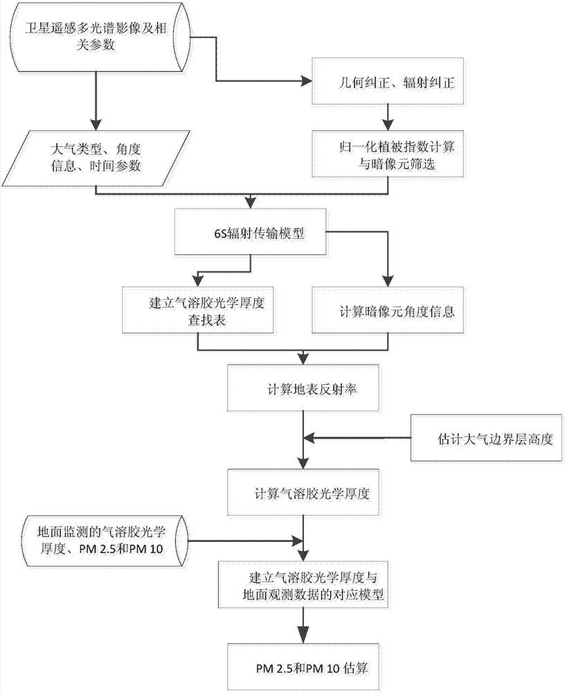
[0040] Such as figure 1 As shown, the present invention provides a method for estimating PM 2.5 and PM 10 using satellite multispectral image data, which includes the following steps:

[0041] S10, geometric correction of satellite images: use ground control points and supporting digital elevation model data to perform geometric correction of satellite images, and perform geocoding for satellite images;

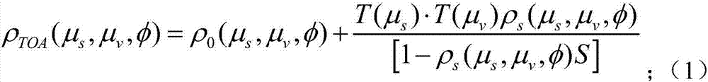
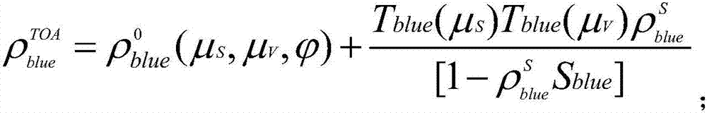
[0042] S20, radiometric correction of satellite images: using radiometric processing parameters to perform absolute radiometric calibration of satellite images and relative radio...


PUM


Abstract

The present invention relates to a method for estimating PM2.5 and PM10 by use of satellite multispectral image data, and the method comprises geometric correction of satellite images, radiometric correction of the satellite images, preprocessing dark pixel selection of remote sensing data, angle information calculation, estimation of aerosol optical thickness, and estimation of the PM2.5 and the PM10. Compared with crowd sourcing data, the relationship between the aerosol optical thickness of each dark pixel and near ground air observation indexes is established, and the PM2.5 and the PM10 are estimated. The method can achieve large-scale, stable and fine PM2.5 and PM10 estimation, and meets the requirements of application of satellite remote sensing technology in wide range environmental monitoring especially in air quality evaluation.

Description

technical field [0001] The invention relates to the field of surveying and mapping science and technology, more specifically, the invention relates to a method for estimating PM 2.5 and PM 10 using satellite multispectral image data. Background technique [0002] In recent years, frequent large-scale and long-term air pollution events have seriously affected people's normal production and life, and regional pollution forms have gradually become prominent. Especially in large cities with relatively developed economies and dense populations, regional air pollution has become a research topic. hotspot. The monitoring data of environmental monitoring stations usually include SO2, NO2, PM2.5, PM10, etc. Among them, the detection of inhalable particulate matter, PM2.5 and PM10 are currently the focus of attention, because their diameters are less than 2.5um and 10um respectively, which not only cause harm to the human body Direct harm, but also adsorb other pollutant gas molecule...

Claims


Application Information

Patent Timeline
IPC IPC(8): G01N15/06
CPCG01N15/06
Inventor 王博张竹林岳照溪凌霄董克松胡旭东卢毅黄方红
Owner NANJING UNIV OF AERONAUTICS & ASTRONAUTICS
Why Eureka
Try Eureka