
Satellite navigation positioning enhancing system and method in indoor environment

A satellite navigation and indoor environment technology, applied in the field of satellite navigation, can solve the problems of endangering the personal safety of rescuers, deploying transponders, and spending a lot of time, and achieve the effects of realizing navigation and positioning, improving broadcasting efficiency, and shortening regeneration time

Pending Publication Date: 2017-07-25
神州天衡科技(深圳)有限公司
View PDF8 Cites 19 Cited by
  • Summary
  • Abstract
  • Description
  • Claims
  • Application Information

AI Technical Summary

Problems solved by technology

When the vehicle is running abnormally, it is impossible to accurately report the location of the accident, resulting in the inability to carry out rapid rescue and traffic relief work; especially for key vehicles such as two passengers and one dangerous vehicle, once a traffic accident occurs in the tunnel, if the rescue cannot be carried out in a timely and effective manner, it will be There will be serious safety hazards, which seriously threaten people's lives and property safety; and the user experience is not good, and it is impossible to predict in advance whether the passage in the tunnel is smooth or not, and it is impossible to make a reasonable route to avoid the tunnel in advance, resulting in blind traffic jams and traffic jams in the tunnel. Problems such as delaying the user's journey
[0003] Based on pseudolite enhancement technology, indoor satellite navigation technology and navigation signal forwarding technology, etc., due to the need to use special navigation terminals and the difficulty of project implementation, such as: it is impossible to deploy transponder receiving antennas and signal lines on the water surface in the river crossing tunnel Cables cannot be laid, etc., and it is impossible to solve the problem of satellite navigation and positioning in the tunnel environment without changing the vehicle navigation terminal. Due to the blind area of ​​navigation, it has caused great trouble to the rescue work, and it often takes a lot of time to conduct blind searches, resulting in the death of the trapped people, and even endangering the personal safety of the rescuers. The above problems need to be solved urgently

Method used


Image

  • Satellite navigation positioning enhancing system and method in indoor environment
  • Satellite navigation positioning enhancing system and method in indoor environment
  • Satellite navigation positioning enhancing system and method in indoor environment

Examples


Embodiment Construction

[0038] In order to make the purpose, technical solutions and advantages of the embodiments of the present invention clearer, the following will clearly and completely describe the technical solutions of the embodiments of the present invention in conjunction with the drawings in the embodiments of the present invention. Obviously, the described embodiments are Some embodiments of the present invention, but not all embodiments. Based on the embodiments of the present invention, all other embodiments obtained by persons of ordinary skill in the art without making creative efforts fall within the protection scope of the present invention.

[0039] The present invention will be further described in detail below in conjunction with the accompanying drawings and specific embodiments.

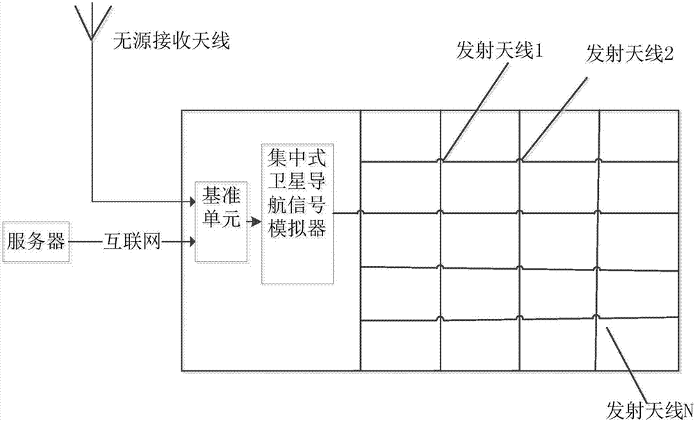
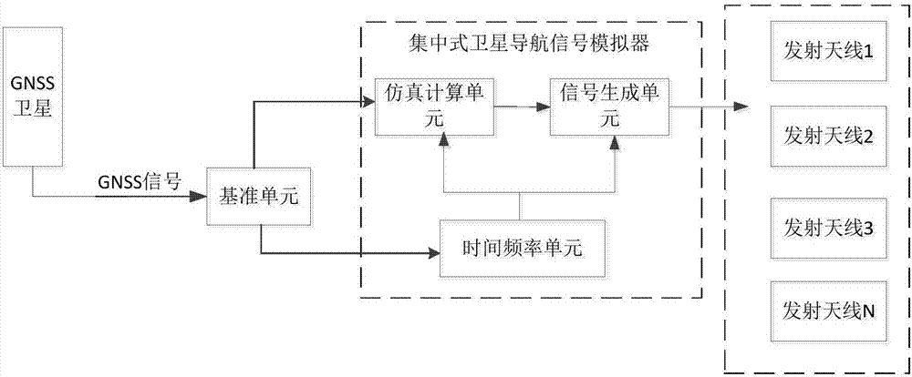
[0040] The schematic diagram of the system shown in the embodiment of the present invention is shown in figure 1 , a satellite navigation and positioning enhancement system in an indoor environment, ...


PUM


Abstract

The invention relates to the field of satellite navigation, and discloses a satellite navigation positioning enhancing system in an indoor environment. The system comprises a reference unit, a centralized satellite navigation signal simulator and N transmitting antennas, the reference unit and the centralized satellite navigation signal simulator are connected successively, and the N transmitting antennas are connected with the centralized satellite navigation signal simulator, and emit N regenerated satellite navigation signals synchronously. The invention also discloses a satellite navigation positioning enhancing method in the indoor environment. Satellite navigation signals in an indoor area are received instantly or reference signals are obtained via the Internet, and navigation signals synchronized with signals of a real satellite navigation system in the indoor area are generated and broadcast in real time indoor. Indoor satellite navigation positioning is realized without change of a navigation terminal. The system of the invention is low in construction difficulty, low in cost and general and supports GNSS systems.

Description

technical field [0001] The invention mainly relates to the field of satellite navigation, in particular to a satellite navigation positioning enhancement system and method in an indoor environment. Background technique [0002] In order to speed up the connection of roads and roads, tunnels are often opened in mountains or underwater to improve the efficiency of traffic and logistics. In a typical indoor environment such as a tunnel, because the satellite navigation signal is blocked, the vehicles in the tunnel cannot receive the satellite navigation signal for positioning, and the occurrence of traffic accidents in the tunnel is also more prominent. When the vehicle is running abnormally, it is impossible to accurately report the location of the accident, resulting in the inability to carry out rapid rescue and traffic relief work; especially for key vehicles such as two passengers and one dangerous vehicle, once a traffic accident occurs in the tunnel, if the rescue cannot...

Claims


Application Information

Patent Timeline
Patent Type & Authority Applications(China)
IPC IPC(8): G01S19/03G01S19/08
CPCG01S19/03G01S19/08
Inventor 明德祥钟小鹏刘志俭谢正娟
Owner 神州天衡科技(深圳)有限公司
Learn More