A method and device for calculating a key value based on a recorder management platform

A management platform and recorder technology, applied in geographic information databases, special data processing applications, structured data retrieval, etc., can solve problems affecting platform operation performance, recorder management platform without offset value cache, etc.

Active Publication Date: 2020-10-23
AEROSPACE HI TECH HLDG GROUP
View PDF3 Cites 0 Cited by
  • Summary
  • Abstract
  • Description
  • Claims
  • Application Information

AI Technical Summary

Problems solved by technology

[0004] The purpose of the present invention is to solve the problem that the existing recorder management platform does not have the offset value buffer function, and when the amount of coordinate data received is large, it seriously affects the operating performance of the platform, and proposes a recorder management platform based on Accelerated coordinate transformation method and device

Method used


Image

  • A method and device for calculating a key value based on a recorder management platform
  • A method and device for calculating a key value based on a recorder management platform
  • A method and device for calculating a key value based on a recorder management platform

Examples


specific Embodiment approach 1

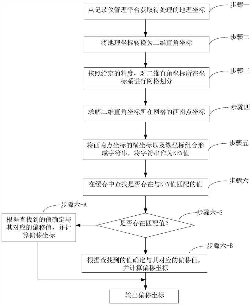
[0020] Specific implementation mode one: the KEY value calculation method based on the recorder management platform of this embodiment is as follows: figure 1 shown, including:

[0021] Step 1: Obtain the geographic coordinates to be processed.

[0022] Step 2: Transform the geographic coordinates into two-dimensional Cartesian coordinates. The units of geographic coordinates are degrees, and the units of two-dimensional Cartesian coordinates are centimeters.

[0023] For example, take the point where the meridian passes the equator as the origin, the longitude as the abscissa, the latitude as the ordinate, and the east longitude and north latitude as positive, establish a coordinate system, then the calculation of the two-dimensional Cartesian coordinates of each point in the east longitude and north latitude area on the earth surface The method is as follows, the unit is meter.

[0024] Abscissa: x=R*(lng*cos(lat*PI / 180)*PI / 180)

[0025] Ordinate: y=R*(lat*PI / 180)

[00...

specific Embodiment approach 2

[0035] Specific embodiment two: this embodiment The difference between this embodiment and specific embodiment one is: the method also includes step six: check whether there is a value matching the KEY value in the cache; if it exists, then according to the search Determine the offset value corresponding to the obtained value, and calculate the offset coordinate; if it does not exist, obtain the offset coordinate of the coordinate corresponding to the KEY value through the network, and calculate the offset value of the offset coordinate and store it in the cache.

[0036] When there is a value matching the KEY value, step six specifically includes the following steps:

[0037] Step A1: Get the KEY value.

[0038] Step A2: Obtain the offset corresponding to the KEY value.

[0039] Step A3: Calculate the Cartesian coordinates of the coordinates corresponding to the KEY value. The Cartesian coordinates here are the horizontal and vertical coordinates that split the string of th...

specific Embodiment approach 3

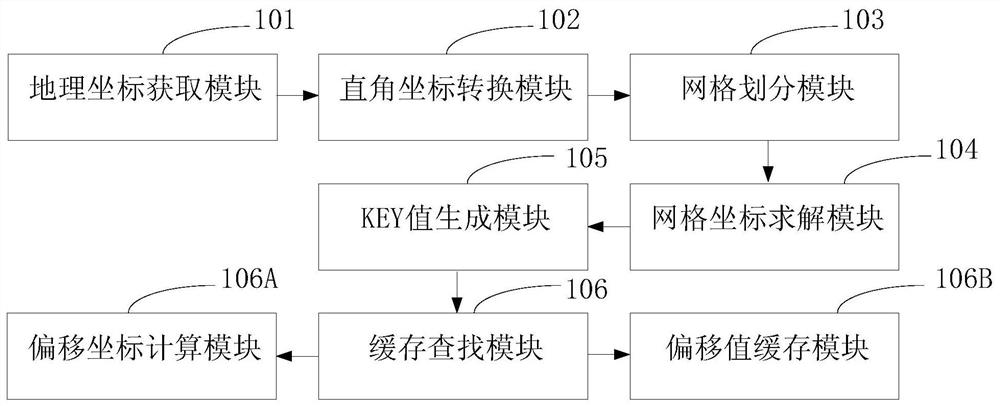
[0045] Specific implementation mode three: this implementation mode provides a KEY value calculation device based on the recorder management platform, such as figure 2 shown, including:

[0046] The geographic coordinate acquiring module 101 is configured to acquire the geographic coordinates to be processed.

[0047] Cartesian coordinate conversion module 102, configured to convert the geographic coordinates into two-dimensional rectangular coordinates.

[0048] The grid division module 103 is configured to perform grid division on the coordinate system where the two-dimensional Cartesian coordinates are located according to a given precision.

[0049] The grid coordinate solving module 104 is configured to solve the coordinates of the southwest point of the grid where the two-dimensional Cartesian coordinates are located.

[0050] The KEY value generating module 105 is configured to combine the abscissa and ordinate of the southwest point coordinates to form a character s...


PUM


Abstract

The invention relates to a recorder management platform-based acceleration coordinate conversion method and apparatus, and belongs to the field of electronic map vehicle position information processing. In order to overcome the shortcoming that the operation performance of a platform is seriously influenced when a quantity of received coordinate data is relatively large because the existing recorder management platform does not have a deviation value caching function, the recorder management platform-based acceleration coordinate conversion method and apparatus is proposed. The method comprises the steps of converting to-be-processed geographic coordinates into two-dimensional rectangular coordinates; according to given precision, performing grid division on a coordinate system; solving southwest point coordinates of a grid where the coordinates are located; and combining horizontal coordinates and longitudinal coordinates of the southwest point coordinates to form a character string, which serves as a KEY value, wherein the KEY value is used for representing the coordinates of the grid where the to-be-processed geographic coordinates are located. The method and the apparatus are suitable for electronic map positioning of the recorder management platform.

Description

technical field [0001] The invention relates to a method and device for calculating a KEY value based on a recorder management platform, and belongs to the field of electronic map vehicle position information processing. Background technique [0002] When the recorder management platform displays vehicle location information on the electronic map, it first needs to perform offset conversion on the coordinates, and then use the converted offset coordinates to display them correctly on the electronic map. The platform needs to access the coordinate offset service issued by the map service provider designated by the Ministry of Communications through the external network to be able to convert the coordinates normally. Due to the large number of vehicles on the platform and the high frequency of uploading coordinates, real-time coordinate conversion through the external network has seriously affected the operational performance of the platform. [0003] Because the vehicles on ...

Claims


Application Information

Patent Timeline
Patent Type & Authority Patents(China)
IPC IPC(8): G06F16/29
CPCG06F16/29
Inventor 姜军李德贤邓舸刘明月陈玉峰郑祥滨
Owner AEROSPACE HI TECH HLDG GROUP
Why Eureka
Try Eureka