Agricultural insurance survey and loss assessment system and implementation method thereof

A technology for loss determination and agriculture, which is applied in the field of agricultural insurance survey and loss determination system, can solve the problems of low efficiency, difficult to do fine survey, high cost, etc., and achieve the effect of rapid judgment basis

Inactive Publication Date: 2017-09-15
中科光启空间信息技术有限公司
View PDF3 Cites 33 Cited by
  • Summary
  • Abstract
  • Description
  • Claims
  • Application Information

AI Technical Summary

Problems solved by technology

[0005] The purpose of the present invention is to solve the problems existing in the existing agricultural insurance in the stages of planting insurance survey and loss determination, which are not easy to achieve fine survey, loss determination, poor timeliness, high cost, and low efficiency, and provide a geographical information fusion Technology, remote sensing technology, and satellite positioning technolo

Method used


Image

  • Agricultural insurance survey and loss assessment system and implementation method thereof
  • Agricultural insurance survey and loss assessment system and implementation method thereof

Examples


Embodiment Construction

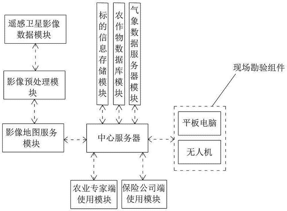
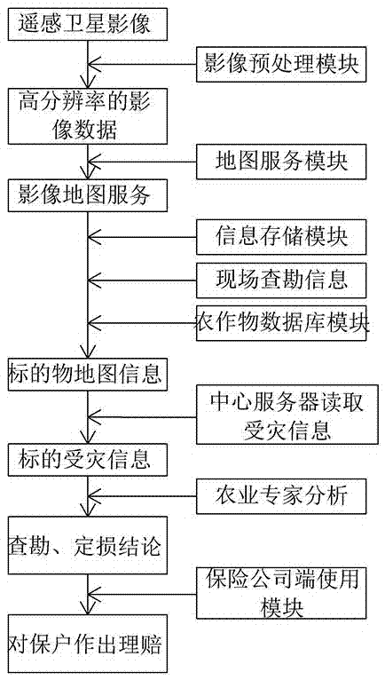
[0033] The core of the present invention is to provide an agricultural insurance survey and loss assessment system and its realization method.

[0034] Below in conjunction with accompanying drawing, the content of the present invention will be further described, a kind of agricultural insurance investigation, loss assessment system, such as figure 1 As shown, it includes the remote sensing satellite image data module, the image preprocessing module having a communication data connection with the remote sensing satellite image data module, the image map service module having a communication data connection with the image preprocessing module, and the image map service module having communication data connected central server, the central server is connected to the marked information storage module, the crop database module, the weather data server module, the on-site inspection component, the agricultural expert end use module and the insurance company end use module through the ...


PUM


Abstract

The invention belongs to the technical field of agricultural insurance, and particular relates to an agricultural insurance survey and loss assessment system capable of combining a geographic information technology, a remote sensing technology and a satellite positioning technology and an implementation method thereof. The system comprises a remote sensing satellite image data module, an image preprocessing module, an image map service module and a central server, wherein the image preprocessing module is in communication data connection with the remote sensing satellite image data module; the image map service module is in the communication data connection with the image preprocessing module; the central server is in the communication data connection with the image map service module; and the central server is connected with an object information storage module, a crop database module, a meteorological data server module, a scene investigation component, a module used for an agricultural expert side and a module used for an insurance company side through a data communication line. By use of the agricultural insurance survey and loss assessment system and the implementation method thereof provided by the invention, a damage area can be accurately measured extensively, and an accurate judgment basis can be quickly given to the damage range and degree of a damaged object.

Description

technical field [0001] The invention belongs to the technical field of agricultural insurance, and in particular relates to an agricultural insurance investigation and loss assessment system and its realization method which integrate geographic information technology, remote sensing technology and satellite positioning technology. Background technique [0002] Agricultural insurance refers to a kind of economic security that provides economic protection for economic losses caused by natural disasters or accidents that may be encountered in the process of production, breeding and growth of planting (crops) and breeding (livestock). Through the form of insurance, the insurance organization organizes the collective mutual assistance of agricultural practitioners, so that the damaged units or individuals can get due compensation, so as to resume production in time and ensure the smooth progress of agricultural production. [0003] At present, agricultural insurance is an agricul...

Claims


Application Information

Patent Timeline
IPC IPC(8): G06F17/30G06K9/00G06Q50/02G06Q40/08
CPCG06F16/583G06Q40/08G06Q50/02G06V20/188
Inventor 蒋鹏飞苌群杭
Owner 中科光启空间信息技术有限公司
Why Eureka
Try Eureka