Geostationary orbit planar array staring multispectral multimode imaging system

A geostationary orbit, multi-mode imaging technology, applied in the field of remote sensing imaging, can solve the problem of lack of simultaneous imaging of infrared and visible spectrum segments, visible light multi-spectral time-sharing imaging, etc., to achieve the effect of various combinations and meet the needs of use

Inactive Publication Date: 2017-09-22
BEIJING RES INST OF SPATIAL MECHANICAL & ELECTRICAL TECH
View PDF4 Cites 5 Cited by
  • Summary
  • Abstract
  • Description
  • Claims
  • Application Information

AI Technical Summary

Problems solved by technology

[0003] The technical problem solved by the present invention is: to overcome the deficiencies in the prior art, to provide a geostationary orbit surface array staring multi-spectral multi-mode imaging system, which solves the current lack...

Method used


Image

  • Geostationary orbit planar array staring multispectral multimode imaging system
  • Geostationary orbit planar array staring multispectral multimode imaging system
  • Geostationary orbit planar array staring multispectral multimode imaging system

Examples


Embodiment Construction

[0020] Below in conjunction with accompanying drawing, the present invention is described in further detail:

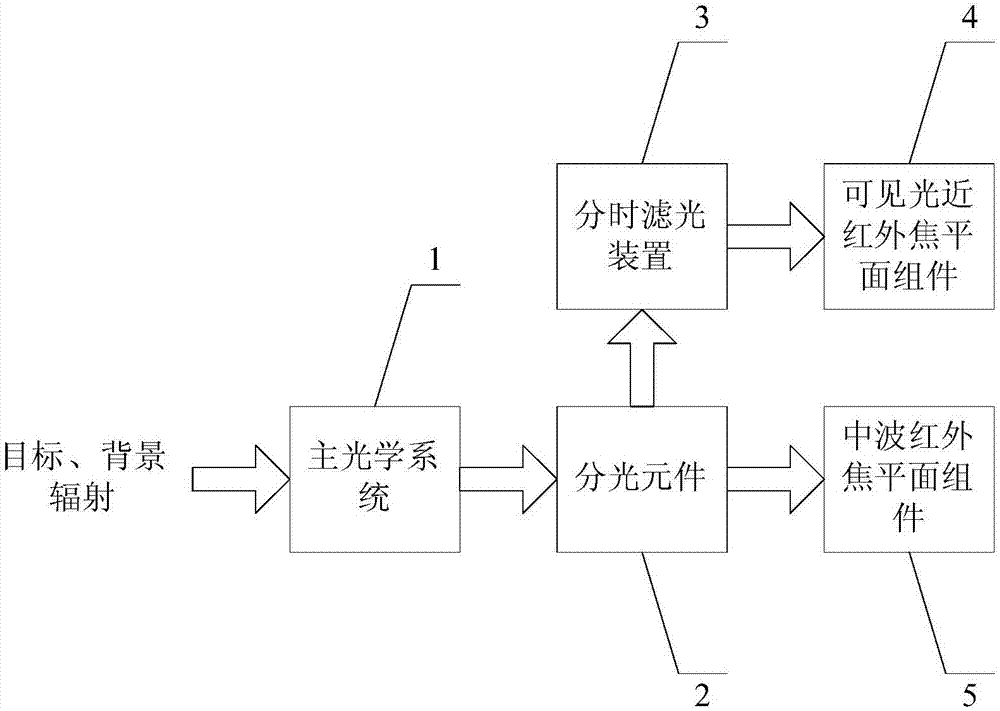
[0021] figure 1 It is a block diagram of the geostationary orbit area array staring multi-spectral multi-mode imaging system of the present invention. Such as figure 1 As shown, the geostationary orbit area array staring multi-spectral multi-mode imaging system includes a main optical system 1, a light splitting element 2, a time-sharing filter device 3, a visible near-infrared focal plane assembly 4, and a mid-wave infrared focal plane assembly 5. The main optical system 1 collects the radiation information of the target and transmits it to the spectroscopic element 2; the spectroscopic element 2 separates the visible near-infrared spectrum from the mid-wave infrared spectrum in the target radiation information, and transmits the visible near-infrared spectrum to the time-sharing filter The optical device 3 converges the mid-wave infrared spectrum to the mid-wave i...


PUM


Abstract

The invention discloses a geostationary orbit surface array staring multi-spectral multi-mode imaging system, comprising: a main optical system, a light splitting element, a time-sharing filter device, a visible near-infrared focal plane assembly and a mid-wave infrared focal plane assembly; wherein, The main optical system collects target radiation information; the spectroscopic element separates the visible near-infrared spectrum from the mid-wave infrared spectrum, the visible near-infrared spectrum is transmitted to the time-sharing filter device, and the mid-wave infrared spectrum converges to the mid-wave infrared focal plane component; the mid-wave infrared focal plane component converts the light signal of the mid-wave infrared spectrum into the first electrical signal; The specified infrared spectrum is converged to the visible near-infrared focal plane component; the visible near-infrared focal plane component converts the optical signal of the specified visible near-infrared spectrum into a second electrical signal. The invention achieves the effect of staring multi-spectrum and multi-mode imaging of the geostationary orbital array.

Description

technical field [0001] The invention belongs to the technical field of remote sensing imaging, and in particular relates to a geostationary orbit surface array staring multi-spectrum multi-mode imaging system. Background technique [0002] Geostationary orbit satellites have a wide monitoring range, high time resolution, and extremely high responsiveness. Under ideal conditions with no clouds during the day, continuous observation, even video observation, of targets in the shooting area can be carried out, and it also has the potential of dynamic target detection and dynamic target indication. Through fast pointing control, satellites can conduct comprehensive observations combining large-scale real-time, continuous maneuvering imaging and high-time resolution imaging, and then can obtain higher spatial resolution and multi-spectral ground image information; Continuous observation, staring observation, regional imaging and mobile imaging, etc., play an important role in mee...

Claims


Application Information

Patent Timeline
IPC IPC(8): G01J3/28
CPCG01J3/2823G01J2003/2826
Inventor 于登云练敏隆董杰王跃石志城王戬许云飞晋利兵赵佳
Owner BEIJING RES INST OF SPATIAL MECHANICAL & ELECTRICAL TECH
Why Eureka
Try Eureka