
Multiline laser radar mass point cloud data rapid and effective extraction and vehicle and lane line feature recognition method

A multi-line laser and point cloud data technology, which is applied in the field of environment perception of unmanned vehicles, can solve the problems of poor anti-interference ability and susceptibility to the environment, and achieve the effect of reducing consumption, reducing requirements, and fast and effective extraction

Pending Publication Date: 2017-09-22
SHANDONG UNIV OF TECH
View PDF5 Cites 28 Cited by
  • Summary
  • Abstract
  • Description
  • Claims
  • Application Information

AI Technical Summary

Problems solved by technology

At present, the detection of lane markings is mainly based on the visual system, which has poor anti-interference ability and is easily affected by factors such as the environment; while the detection of lane markings based on multi-line radar not only has strong anti-interference ability, but is less affected by environmental factors and other factors. High precision and strong real-time performance

Method used


Image

  • Multiline laser radar mass point cloud data rapid and effective extraction and vehicle and lane line feature recognition method
  • Multiline laser radar mass point cloud data rapid and effective extraction and vehicle and lane line feature recognition method
  • Multiline laser radar mass point cloud data rapid and effective extraction and vehicle and lane line feature recognition method

Examples


Embodiment Construction

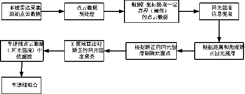
[0009] Such as figure 1 As shown, the present invention proposes a method for quickly and effectively extracting massive point cloud data of lidar without affecting vehicle and lane line feature recognition, which includes: a three-dimensional storage mode of laser radar point cloud data, and three-dimensional coordinates of point cloud data Based on the self-adaptive distance, the r-level point cloud data of the multi-layer point cloud data of the vehicle in the area of ​​interest of the unmanned vehicle is calculated without affecting the identification of vehicle features, and the lane line is recognized according to the return light intensity corrected by distance and angle. The complete technical process is as follows:

[0010] Establish a three-dimensional storage matrix of lidar point cloud data: each lidar point cloud data contains information such as three-dimensional space position coordinates (x, y, z) under a certain spatial reference system, return light intensity...


PUM


Abstract

The unmanned vehicle acquires three-dimensional mass point cloud data (point cloud field) through multiline laser radar for hundreds of MB per second, and the data storage space and processing timeliness have extremely high requirement for the computing resource. The invention provides a multiline laser radar three-dimensional point cloud data rapid and effective extraction method without influencing vehicle and lane line feature recognition. The r layer point cloud data of the vehicle multilayer point cloud data in the area of interest of the unmanned vehicle acquired through multiline laser radar are extracted by adaptive distance. Besides, the invention also provides a lane line extraction method through the return light intensity based on distance and angle correction. The requirement of mass point cloud data processing for the computer hardware can be reduced, the storage space and cost can be saved, the timeliness of point cloud data processing can be accelerated and rapid and effective extraction and feature recognition of the vehicle and lane line point cloud data in the area of interest of the unmanned vehicle can be realized. The method is suitable for multiple urban roads so as to be high in anti-interference capability and great in algorithm robustness.

Description

technical field [0001] The present invention is a technology aimed at the field of environment perception of unmanned vehicles. The amount of three-dimensional point cloud data collected by multi-line laser radar rotation is massive, reaching hundreds of MB per second. Therefore, the present invention can reduce the requirement on computer hardware for massive laser radar point cloud data processing, reduce the consumption of computing resources, and save storage space and computing time. It can realize the rapid and effective extraction of multi-line lidar three-dimensional mass point cloud data without affecting the feature recognition of vehicles; in addition, the multi-line lidar effective data is based on the distance and angle corrected back light intensity to extract lane lines key technologies in the field. The invention is a fast and effective information extraction and processing technology. Background technique [0002] Real-time and accurate identification of t...

Claims


Application Information

Patent Timeline
Patent Type & Authority Applications(China)
IPC IPC(8): G01S7/493
CPCG01S7/493
Inventor 王晓原孔栋高松谭德荣孙亮邵金菊王方孙一帆刘丽萍
Owner SHANDONG UNIV OF TECH
Learn More