Space-borne SAR image geometric rectification method based on priori DEM data

A fine correction, space-borne technology, applied in the field of geometric fine correction of space-borne SAR images based on prior DEM data, can solve problems such as incomplete correspondence, offset, inability to map terrain and landform in detail and accurately, and achieve improved Accuracy, reduced workload, inversion accurate effect

Active Publication Date: 2017-10-10
XIDIAN UNIV
View PDF4 Cites 15 Cited by
  • Summary
  • Abstract
  • Description
  • Claims
  • Application Information

AI Technical Summary

Problems solved by technology

[0003] However, in the process of spaceborne SAR from the launch of radar pulses to the final generation of spaceborne SAR images through imaging algorithms, many non-ideal factors and errors will be introduced into it, which will make each pixel in the actual spaceborne SAR image There will be a certain offset between the position in the corresponding scene and the position in the actual scene, so that the actual spaceborne SAR image does not completely correspond to the real scene, and thus it is impossible to map the terrain and landform in detail and accurately, and obtain information on the earth's surface

Method used


Image

  • Space-borne SAR image geometric rectification method based on priori DEM data
  • Space-borne SAR image geometric rectification method based on priori DEM data
  • Space-borne SAR image geometric rectification method based on priori DEM data

Examples


Embodiment Construction

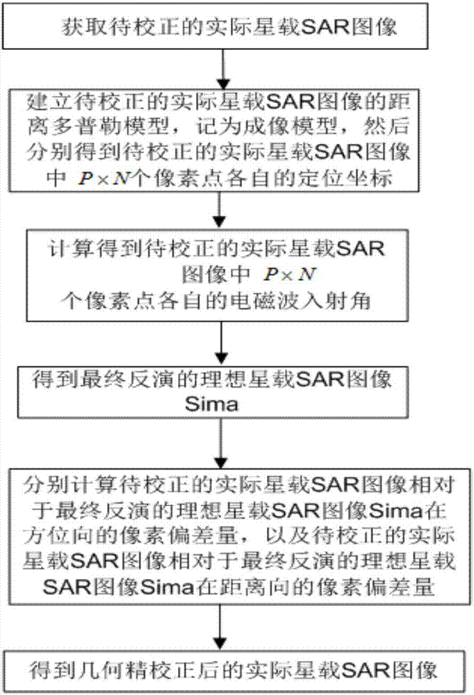
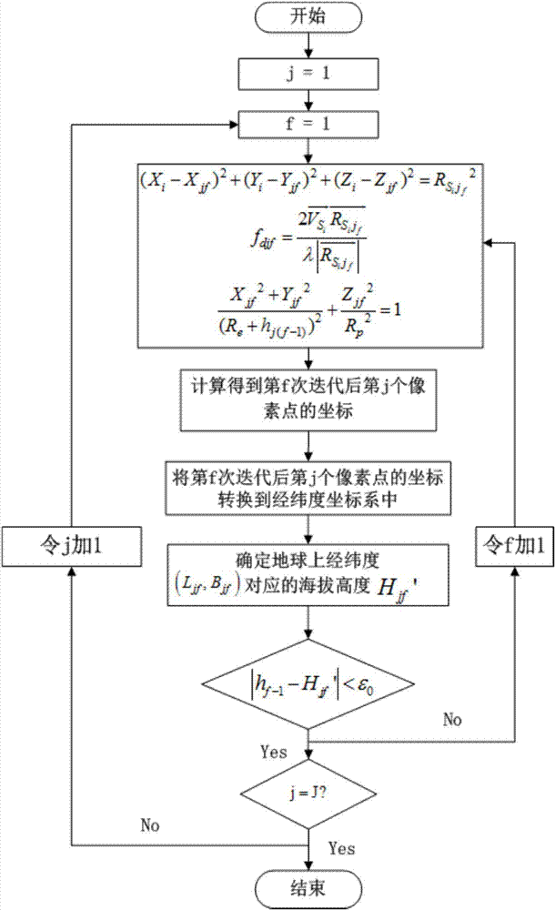
[0028] refer to figure 1 , is a flow chart of a method for precise geometric correction of spaceborne SAR images based on prior DEM data of the present invention; wherein the method for precise geometric correction of spaceborne SAR images based on prior DEM data comprises the following steps:

[0029] Step 1, obtain the actual spaceborne SAR image to be corrected, the actual spaceborne SAR image to be corrected is a P×N dimensional matrix, P represents the number of pixels contained in the azimuth direction of the actual spaceborne SAR image to be corrected, N represents the number of pixels contained in the range direction of the actual spaceborne SAR image to be corrected, and P and N are positive integers greater than 0, respectively.

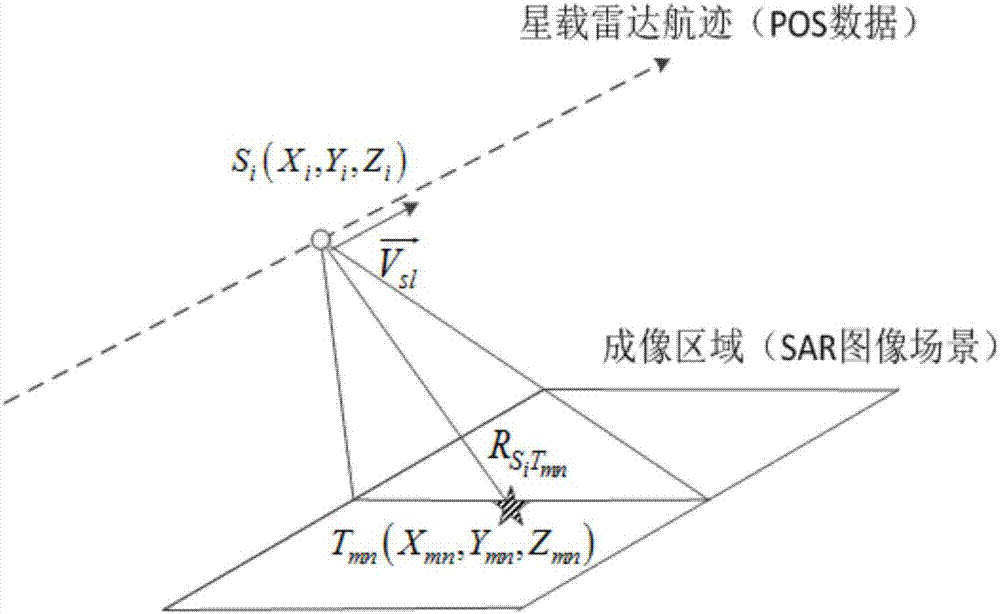
[0030] Specifically, determine the spaceborne SAR, obtain the spaceborne SAR echo data, and then perform imaging processing on the acquired spaceborne SAR echo data through the SAR imaging algorithm to obtain the actual spaceborne SAR image...


PUM


Abstract

The present invention discloses a space-borne SAR image geometric rectification method based on priori DEM data, comprising: obtaining an actual space-borne SAR image to be rectified; establishing a distance Doppler model for the actual space-borne SAR image to be rectified, recorded as an imaging model; then using the imaging model to position P x N pixels in the actual space-borne SAR image to be rectified respectively to obtain the positioning coordinates for the P x N pixels in the actual space-borne SAR image to be rectified; according to the respective positioning coordinates for the P x N pixels in the actual space-borne SAR image to be rectified, further calculating the electromagnetic wave incidence angles of the P x N pixels in the actual space-borne SAR image to be rectified and the finally inverted ideal SAR image Sima; and calculating respectively the pixel deviation amounts na of the actual spaceborne SAR image to be rectified with respect to Sima in the azimuth direction and the pixel deviation amounts nr of the actual space-borne SAR image to be rectified with respect to Sima in the distance direction so as to further calculate the actual SAR image after geometric precise rectification.

Description

technical field [0001] The invention belongs to the technical field of signal processing, and in particular relates to a geometric precision correction method of spaceborne SAR images based on prior DEM data, which is suitable for reducing the deviation of the imaging position of pixels in the SAR image scene caused by spaceborne SAR due to systematic errors. The problem of location points can be solved, thereby improving the imaging quality of spaceborne SAR, and helping users to interpret and interpret SAR images. Background technique [0002] Spaceborne SAR is an effective means of observing the earth from space. It has the advantages of all-day, all-weather, multi-band and high resolution. It can map terrain and landform in detail and accurately, obtain information on the earth's surface, and finally generate targets A high-resolution map of the scene. [0003] However, in the process of spaceborne SAR from the transmission of radar pulses to the final generation of spa...

Claims


Application Information

Patent Timeline
Patent Type & Authority Applications(China)
IPC IPC(8): G01S7/40G01S13/90
CPCG01S7/4052G01S13/90
Inventor 李真芳田锋邢超
Owner XIDIAN UNIV
Why Eureka
Try Eureka