Remote sensing identification method of spring corn

A technology of remote sensing identification and corn, which is applied in the field of agricultural remote sensing, can solve problems such as weak discrimination ability, unfavorable crop type identification, and affecting the accuracy of remote sensing extraction of crops, and achieves high stability.

Inactive Publication Date: 2017-11-03
BEIJING NORMAL UNIVERSITY
View PDF7 Cites 7 Cited by
  • Summary
  • Abstract
  • Description
  • Claims
  • Application Information

AI Technical Summary

Problems solved by technology

[0004] The traditional method of identifying crops based on time series remote sensing images often only uses a certain remote sensing index, especially a certain vegetation index is the most common. This method has a weak ability to distinguish different crops with similar growth cycles and planting structures. , the tolerance to timing noise is low, which affects the accuracy of crop remote sensing extraction
Spring maize has a wide planting range and a wide ecological range, and there are many crop varieties with similar growth and development phenology characteristics. It is difficul

Method used


Image

  • Remote sensing identification method of spring corn

Examples


Embodiment Construction

[0046] The technical implementation of the present invention will be further described below in conjunction with the accompanying drawings.

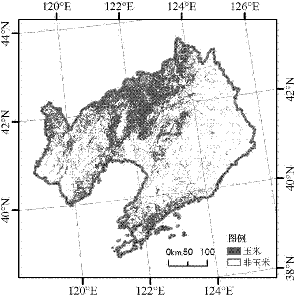
[0047] A. Classification system construction

[0048] According to the structure of ground features in the region and the mixing of spring corn and other ground features in remote sensing spectra, a corresponding classification system was constructed.

[0049] In this case, the types of land features in Liaoning Province are set into six categories: spring corn, rice, woodland (including shrubs), grassland (including other types of crops, such as vegetables, soybeans, etc.), construction land, and water.

[0050] B. Selection of training samples for each object type

[0051] According to the constructed classification system and the phenological calendar of main local crops, based on high spatial resolution remote sensing images and field survey data, following the basic principles of training sample selection, the training samples of v...


PUM


Abstract

The invention discloses a remote sensing identification method of spring corn. The method is characterized in that the spatial distribution information of the spring corn in a regional range is extracted by using the differences between the remote sensing red light reflectivity, near infrared reflectivity and normalized difference vegetation index of the spring corn and those of other surface feature types and through classification system building, training sample selection, surface feature type remote sensing attribute index time sequence curve average extraction, identification feature selection, feature threshold determining and spring corn identification model building. The method has the advantages that discrimination rules can be built by selecting multiple remote sensing attribute indexes according to prior knowledge, then decision tree classification is used to identify the spring corn in the regional range, and high identification precision is achieved; the method is high in stability and universality and applicable to the operation implementation of large-range spring corn remote sensing extraction.

Description

technical field [0001] The invention relates to the technical field of agricultural remote sensing, in particular to a remote sensing extraction method for spatial distribution information of spring corn. Background technique [0002] Remote sensing has the characteristics of large-scale synchronous observation, high timeliness, and low cost. It can relatively conveniently obtain large-scale and full-coverage spatial distribution information of crops, and has been widely used to extract crop planting ranges. [0003] Crop remote sensing recognition methods include methods based on single-period remote sensing images and methods based on remote sensing time-series images. Different types of crops of the same season often have similar spectral characteristics in remote sensing images under large-scale conditions. Single-period remote sensing images generally have the phenomenon of different objects with the same spectrum, which cannot effectively distinguish crop types. The r...

Claims


Application Information

Patent Timeline
IPC IPC(8): G01N21/55G01N21/17G01N21/3563G01N21/359
CPCG01N21/17G01N21/3563G01N21/359G01N21/55G01N2021/1765G01N2021/178G01N2021/1797
Inventor 朱文泉唐珂詹培
Owner BEIJING NORMAL UNIVERSITY
Why Eureka
Try Eureka