Grid-vector data conversion and continuous scale representation method based on image pyramid

A vector data and expression method technology, applied in image data processing, 2D image generation, image enhancement, etc., can solve the labor cost limitation of vectorization efficiency and accuracy, increase the time complexity of geospatial data processing, and difficult to obtain continuous scales expression, etc.

Active Publication Date: 2017-11-10
HUAZHONG NORMAL UNIV
View PDF6 Cites 11 Cited by
  • Summary
  • Abstract
  • Description
  • Claims
  • Application Information

AI Technical Summary

Problems solved by technology

However, on the one hand, traditional multi-scale representations are processed separately based on different data sources in the field of remote sensing and cartographic synthesis. This data processing method greatly increases the time complexity of geospatial data processing; on the other hand, vector The multi-scale expression of data generally only expresses the results on a limited scale, and it is difficult to obtain continuous scale expression beyond the limited scale
Traditional raster-vector data conversion uses manual vectorization, but with the massive growth of geospatial data, the human cost and human error of manual vectorization limit the improvement of vectorization efficiency and accuracy

Method used


Image

  • Grid-vector data conversion and continuous scale representation method based on image pyramid
  • Grid-vector data conversion and continuous scale representation method based on image pyramid
  • Grid-vector data conversion and continuous scale representation method based on image pyramid

Examples


Embodiment Construction

[0037] In order to facilitate those of ordinary skill in the art to understand and implement the present invention, the present invention will be described in further detail below in conjunction with the accompanying drawings and embodiments. It should be understood that the implementation examples described here are only used to illustrate and explain the present invention, and are not intended to limit this invention.

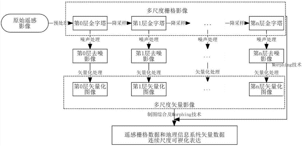
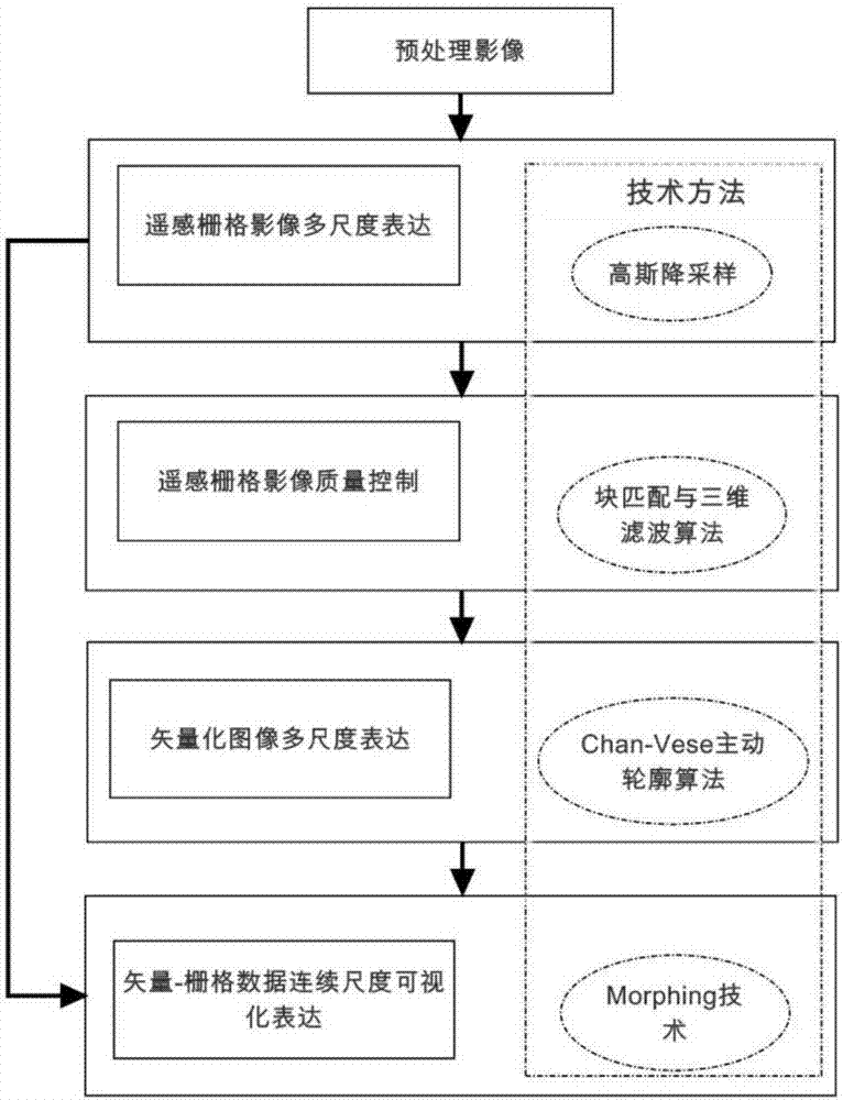
[0038] see figure 1 and figure 2 A method for automatic conversion and continuous expression of raster-vector data based on an image pyramid provided by an embodiment of the present invention includes the following steps:

[0039] Step 1: Preprocessing the remote sensing images;

[0040] Step 1.1, select the cloud shadow area, hill shadow area on the original remote sensing image, or select the water body area with a gray value less than 8 on the near-infrared band or the vegetation area with a gray value less than 5 on the red band as the area of ​​intere...


PUM


Abstract

The invention discloses a grid-vector data conversion and continuous scale representation method based on an image pyramid. The method comprises the following steps of firstly, carrying out preprocessing on a remote sensing image and carrying out multiscale visual representation on the preprocessed image to obtain a multiscale grid remote sensing image; secondly, carrying out noise processing on the multiscale grid remote sensing image obtained in the step 2 and carrying out automatic vectorization operation on the multiscale grid remote sensing image after noise processing; and lastly, carrying out simplification treatment on the image after automatic vectorization operation in order to obtain continuous scale representation of a vector image after simplification treatment. According to the method, the present matured remote sensing image processing technology and cartographic generalization are comprehensively and organically fused, and the automation of grid-vector data conversion of the remote sensing image data and the continuous scale representation of the remote sensing grid data and the map vector data are realized, so that the efficiency and the effect of geographical spatial data processing are greatly improved.

Description

technical field [0001] The invention belongs to the technical field of remote sensing image processing and cartography synthesis, and relates to a geospatial data grid-vector automatic conversion and continuous scale expression method, in particular to a geospatial data grid that integrates remote sensing data processing and map cartography synthesis -Vector automatic conversion and continuous scale expression method. Background technique [0002] The multi-scale expression of geospatial data is one of the important contents in the field of photogrammetry and remote sensing, as well as in the field of cartography and geographic information system. , image classification, and mixed pixel decomposition provide entry points; in the field of geographic information systems, the multi-scale expression of geographic elements is based on the existing cartographic rules and the distribution of thematic features to combine spatial data between scales and apply them to multiple Scale-...

Claims


Application Information

Patent Timeline
Patent Type & Authority Applications(China)
IPC IPC(8): G06T11/00G06T5/00
CPCG06T5/002G06T11/001G06T2207/10032G06T2207/20221G06T2207/30181
Inventor 李畅刘晓娟
Owner HUAZHONG NORMAL UNIV
Why Eureka
Try Eureka